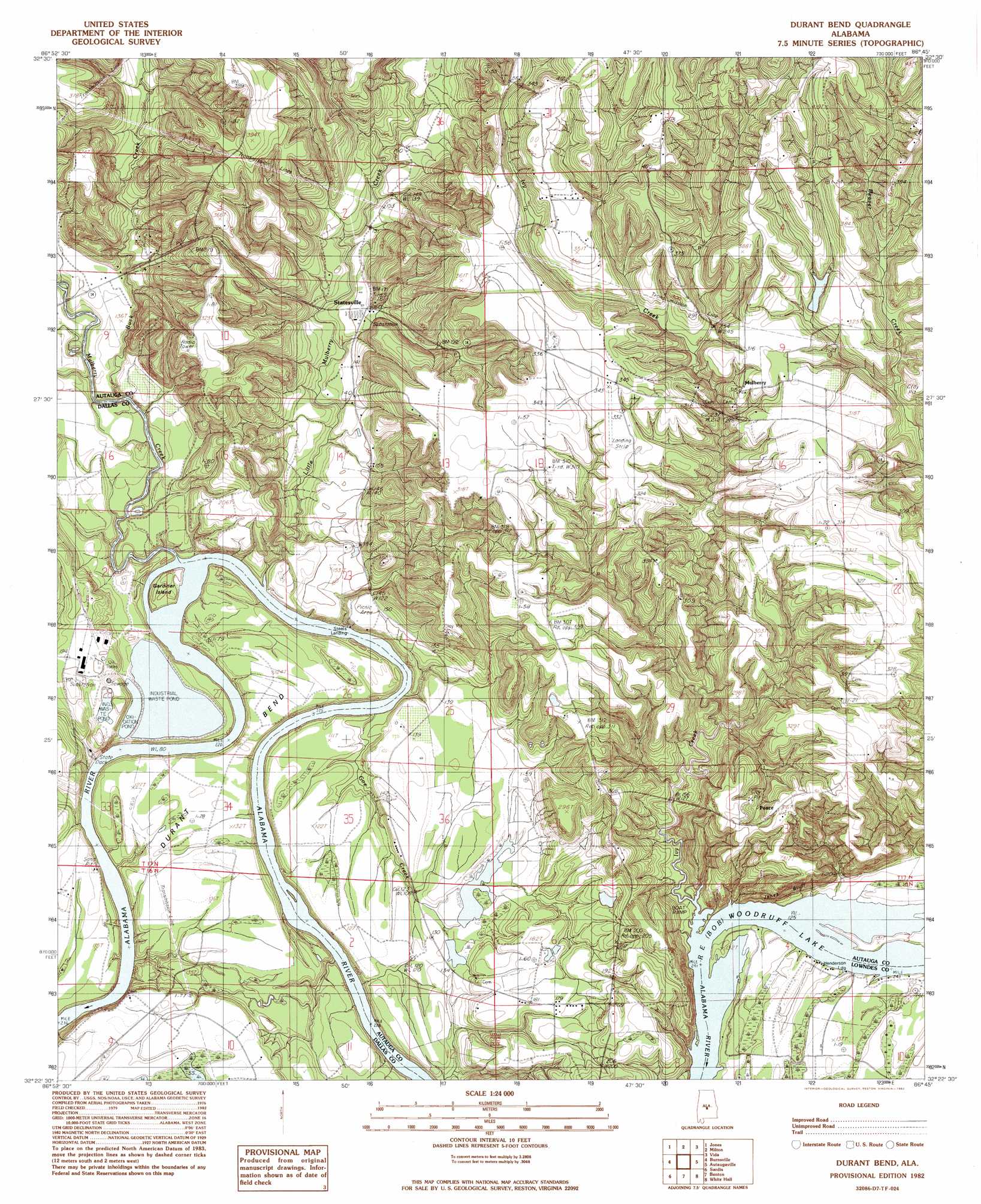
Durant Bend Topo Map Alabama
To zoom in, hover over the map of Durant Bend
USGS Topo Quad 32086d7 - 1:24,000 scale
| Topo Map Name: | Durant Bend |
| USGS Topo Quad ID: | 32086d7 |
| Print Size: | ca. 21 1/4" wide x 27" high |
| Southeast Coordinates: | 32.375° N latitude / 86.75° W longitude |
| Map Center Coordinates: | 32.4375° N latitude / 86.8125° W longitude |
| U.S. State: | AL |
| Filename: | o32086d7.jpg |
| Download Map JPG Image: | Durant Bend topo map 1:24,000 scale |
| Map Type: | Topographic |
| Topo Series: | 7.5´ |
| Map Scale: | 1:24,000 |
| Source of Map Images: | United States Geological Survey (USGS) |
| Alternate Map Versions: |
Benton NE AL 1975, updated 1977 Download PDF Buy paper map Durant Bend AL 1982, updated 1982 Download PDF Buy paper map Durant Bend AL 2011 Download PDF Buy paper map Durant Bend AL 2014 Download PDF Buy paper map |
1:24,000 Topo Quads surrounding Durant Bend
Buck Creek |
Plantersville |
Pletcher |
Billingsley |
White City |
Summerfield |
Jones |
Milton |
Vida |
Old Kingston |
Selma |
Burnsville |
Durant Bend |
Autaugaville |
Forester |
Blackwell Bend |
Sardis |
Benton |
White Hall |
Lowndesboro |
Elm Bluff |
Pleasant Hill |
Collirene |
Gordonsville |
Hayneville |
> Back to 32086a1 at 1:100,000 scale
> Back to 32086a1 at 1:250,000 scale
> Back to U.S. Topo Maps home
Durant Bend topo map: Gazetteer
Durant Bend: Bars
Edwards Bar elevation 38m 124′Gaston Bar elevation 24m 78′
Lower Brother Bar elevation 24m 78′
Morgan Bar elevation 24m 78′
Old Hell Bar elevation 24m 78′
Upper Brother Bar elevation 28m 91′
Durant Bend: Bends
Durant Bend elevation 38m 124′Durant Bend: Cliffs
Cunningham Bluff elevation 28m 91′Jones Bluff elevation 83m 272′
Durant Bend: Dams
Hammermill Waste Treatment Dam elevation 35m 114′Jim Adams Lake Dam elevation 37m 121′
Underwood Lake Dam elevation 92m 301′
Durant Bend: Islands
Gardiner Island elevation 31m 101′Durant Bend: Parks
R E Bob Woodruff Park elevation 38m 124′Selma State Park elevation 37m 121′
Durant Bend: Populated Places
Kalmia (historical) elevation 91m 298′Mulberry elevation 94m 308′
Peace elevation 94m 308′
Statesville elevation 48m 157′
Durant Bend: Reservoirs
Hammermill Waste Treatment Pond elevation 35m 114′Jim Adams Lake elevation 37m 121′
Underwood Lake elevation 92m 301′
Durant Bend: Streams
Buck Creek elevation 30m 98′Ivy Creek elevation 38m 124′
Little Mulberry Creek elevation 24m 78′
Mulberry Creek elevation 30m 98′
Durant Bend digital topo map on disk
Buy this Durant Bend topo map showing relief, roads, GPS coordinates and other geographical features, as a high-resolution digital map file on DVD:
Gulf Coast (LA, MS, AL, FL) & Southwestern Georgia
Buy digital topo maps: Gulf Coast (LA, MS, AL, FL) & Southwestern Georgia
 & Southwestern Georgia map DVD")