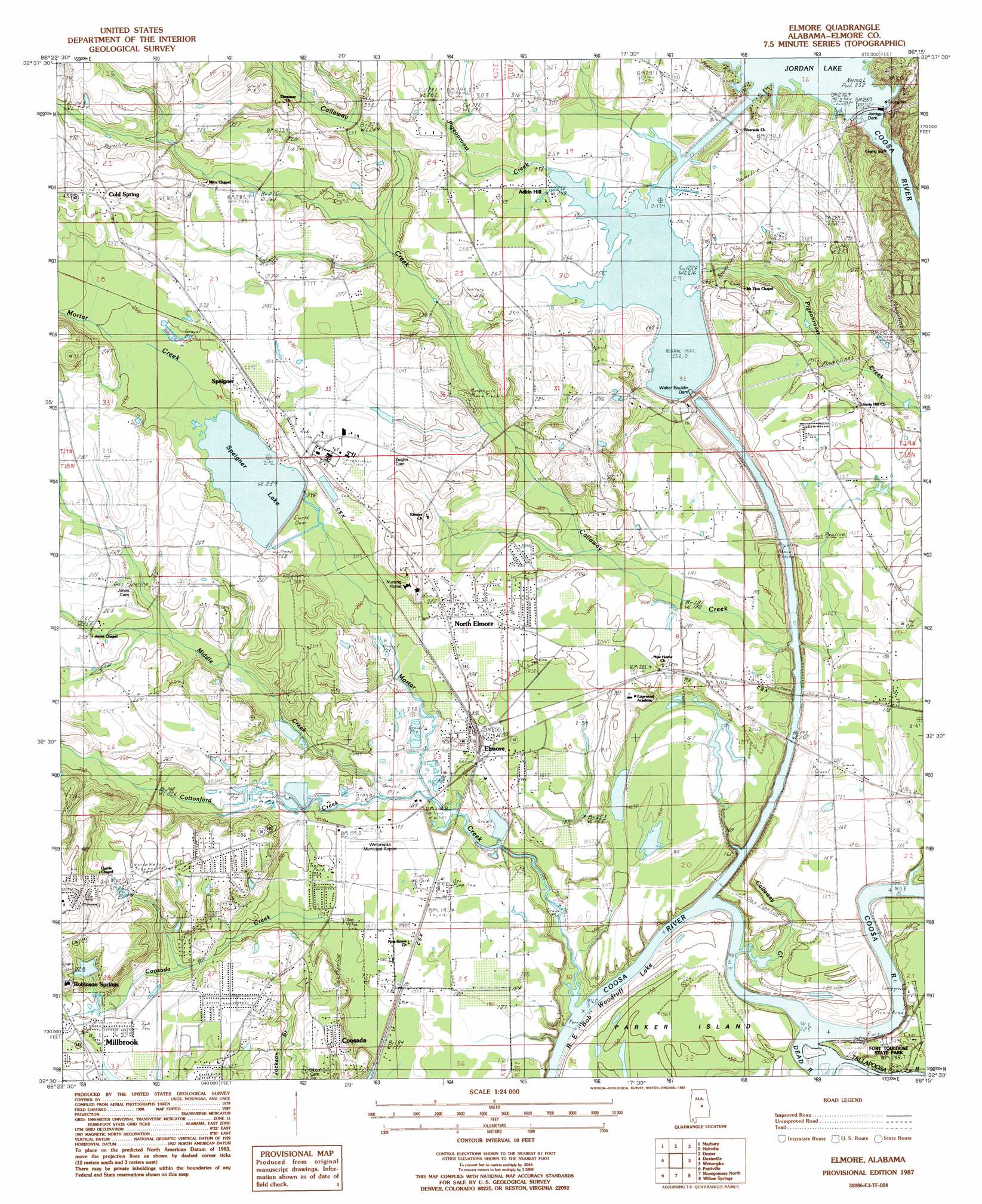
Elmore Topo Map Alabama
To zoom in, hover over the map of Elmore
USGS Topo Quad 32086e3 - 1:24,000 scale
| Topo Map Name: | Elmore |
| USGS Topo Quad ID: | 32086e3 |
| Print Size: | ca. 21 1/4" wide x 27" high |
| Southeast Coordinates: | 32.5° N latitude / 86.25° W longitude |
| Map Center Coordinates: | 32.5625° N latitude / 86.3125° W longitude |
| U.S. State: | AL |
| Filename: | o32086e3.jpg |
| Download Map JPG Image: | Elmore topo map 1:24,000 scale |
| Map Type: | Topographic |
| Topo Series: | 7.5´ |
| Map Scale: | 1:24,000 |
| Source of Map Images: | United States Geological Survey (USGS) |
| Alternate Map Versions: |
Elmore SE AL 1975, updated 1977 Download PDF Buy paper map Elmore AL 1987, updated 1987 Download PDF Buy paper map Elmore AL 1987, updated 1987 Download PDF Buy paper map Elmore AL 2011 Download PDF Buy paper map Elmore AL 2014 Download PDF Buy paper map |
1:24,000 Topo Quads surrounding Elmore
Clanton East |
Mitchell Dam |
Richville |
Rockford Sw |
Equality |
White City |
Marbury |
Holtville |
Dexter |
Eclectic |
Old Kingston |
Deatsville |
Elmore |
Wetumpka |
Claud |
Forester |
Prattville |
Montgomery North |
Willow Springs |
Brassell |
Lowndesboro |
Cantelous |
Montgomery South |
Barachias |
Mount Meigs |
> Back to 32086e1 at 1:100,000 scale
> Back to 32086a1 at 1:250,000 scale
> Back to U.S. Topo Maps home
Elmore topo map: Gazetteer
Elmore: Airports
Wetumpka Municipal Airport elevation 58m 190′Elmore: Canals
Alabama River Canal elevation 60m 196′Elmore: Crossings
Parker Ferry (historical) elevation 37m 121′Elmore: Dams
B D Greer Dam elevation 45m 147′Jordan Dam elevation 54m 177′
Speigner Dam elevation 69m 226′
W A Williamson Dam elevation 89m 291′
Walter Bouldin Dam elevation 49m 160′
Elmore: Islands
Parker Island elevation 43m 141′Elmore: Parks
Fort Toulouse National Historic Park elevation 45m 147′Fort Toulouse State Park elevation 46m 150′
Elmore: Populated Places
Adkin Hill elevation 80m 262′Broadmoor elevation 72m 236′
Cold Spring elevation 100m 328′
Elmore elevation 62m 203′
North Elmore elevation 67m 219′
Overton Heights elevation 70m 229′
Speigner elevation 87m 285′
Springdale elevation 75m 246′
Springfield elevation 112m 367′
Tuskugu elevation 50m 164′
Elmore: Post Offices
Elmore Post Office elevation 61m 200′Elmore: Reservoirs
Greer Lake elevation 45m 147′Jordan Lake elevation 77m 252′
Jordan Lake Diversion elevation 49m 160′
Speigner Lake elevation 73m 239′
Williamsons Lake elevation 89m 291′
Elmore: Streams
Callaway Creek elevation 37m 121′Cottonford Creek elevation 51m 167′
Dead River elevation 38m 124′
Hurricane Branch elevation 72m 236′
Middle Creek elevation 49m 160′
Mortar Creek elevation 42m 137′
Tallapoosa River elevation 38m 124′
Elmore: Summits
Taskigi Mound elevation 50m 164′Elmore digital topo map on disk
Buy this Elmore topo map showing relief, roads, GPS coordinates and other geographical features, as a high-resolution digital map file on DVD:
Gulf Coast (LA, MS, AL, FL) & Southwestern Georgia
Buy digital topo maps: Gulf Coast (LA, MS, AL, FL) & Southwestern Georgia
 & Southwestern Georgia map DVD")