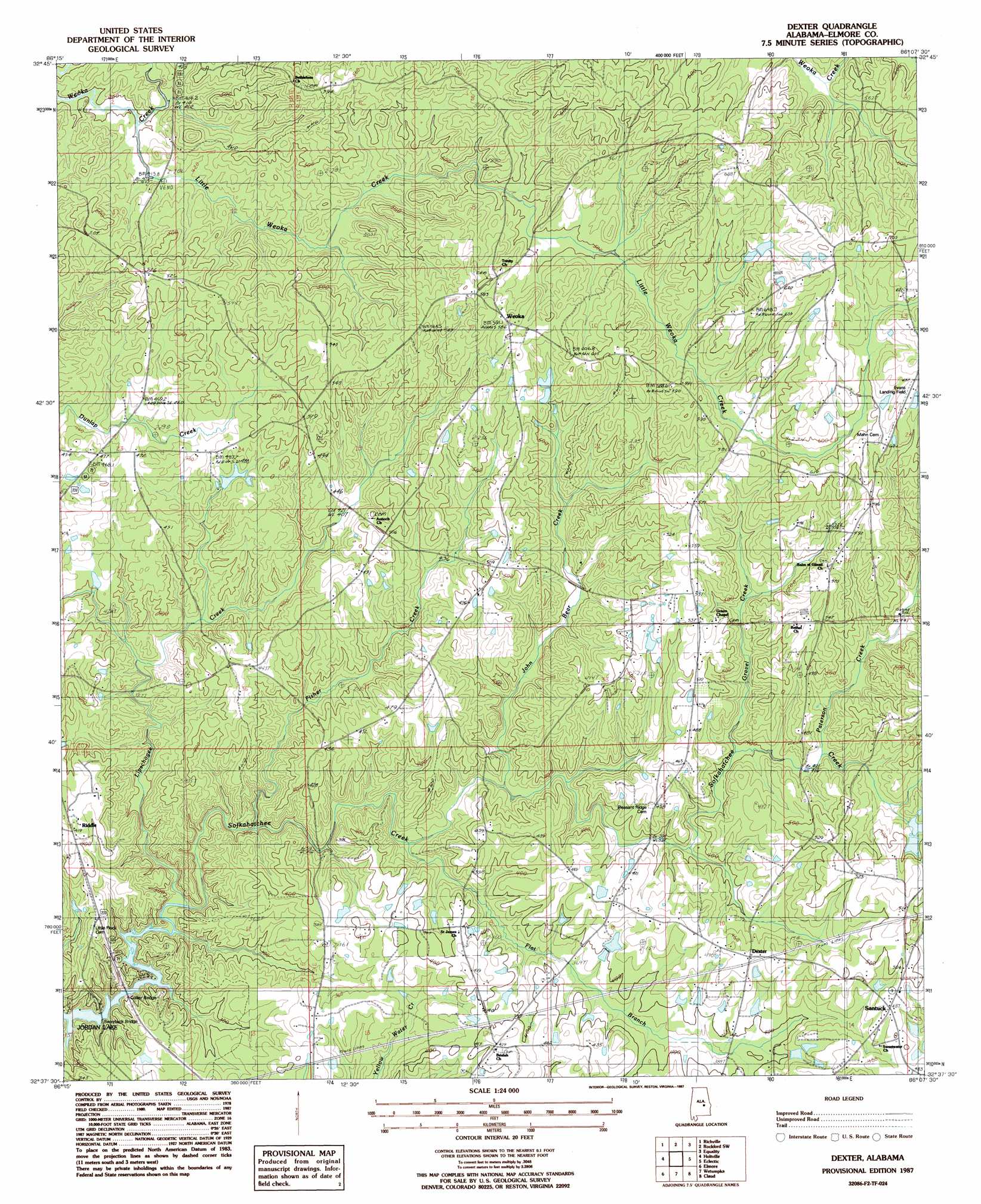
Dexter Topo Map Alabama
To zoom in, hover over the map of Dexter
USGS Topo Quad 32086f2 - 1:24,000 scale
| Topo Map Name: | Dexter |
| USGS Topo Quad ID: | 32086f2 |
| Print Size: | ca. 21 1/4" wide x 27" high |
| Southeast Coordinates: | 32.625° N latitude / 86.125° W longitude |
| Map Center Coordinates: | 32.6875° N latitude / 86.1875° W longitude |
| U.S. State: | AL |
| Filename: | o32086f2.jpg |
| Download Map JPG Image: | Dexter topo map 1:24,000 scale |
| Map Type: | Topographic |
| Topo Series: | 7.5´ |
| Map Scale: | 1:24,000 |
| Source of Map Images: | United States Geological Survey (USGS) |
| Alternate Map Versions: |
Dexter AL 1987, updated 1987 Download PDF Buy paper map Dexter AL 2011 Download PDF Buy paper map Dexter AL 2014 Download PDF Buy paper map |
1:24,000 Topo Quads surrounding Dexter
Mitchell Dam Nw |
Flag Mountain |
Rockford |
Kellyton |
Alexander City |
Mitchell Dam |
Richville |
Rockford Sw |
Equality |
Our Town |
Marbury |
Holtville |
Dexter |
Eclectic |
Red Hill |
Deatsville |
Elmore |
Wetumpka |
Claud |
Tallassee |
Prattville |
Montgomery North |
Willow Springs |
Brassell |
Shorter |
> Back to 32086e1 at 1:100,000 scale
> Back to 32086a1 at 1:250,000 scale
> Back to U.S. Topo Maps home
Dexter topo map: Gazetteer
Dexter: Airports
Evans Airport elevation 194m 636′Dexter: Bridges
Collier Bridge elevation 78m 255′Swayback Bridge elevation 77m 252′
Dexter: Dams
B G Powell Lake Dam elevation 138m 452′Davis Dam elevation 136m 446′
Milam Lake Dam elevation 126m 413′
Stewart Dam elevation 145m 475′
Whetstone Dam elevation 162m 531′
Dexter: Populated Places
Dexter elevation 139m 456′Greer elevation 164m 538′
Riddle elevation 127m 416′
Santuck elevation 148m 485′
Ten Cedars Estates elevation 126m 413′
Weoka elevation 179m 587′
Dexter: Reservoirs
B G Powell Lake elevation 138m 452′Davis Lake elevation 136m 446′
Milam Lake elevation 126m 413′
Stewart Lakes elevation 151m 495′
Whits Lake elevation 162m 531′
Dexter: Streams
Fisher Creek elevation 87m 285′Gravel Creek elevation 115m 377′
John Bear Creek elevation 103m 337′
Lipschogee Creek elevation 98m 321′
Little Weoka Creek elevation 122m 400′
Paterson Creek elevation 128m 419′
Dexter digital topo map on disk
Buy this Dexter topo map showing relief, roads, GPS coordinates and other geographical features, as a high-resolution digital map file on DVD:
Gulf Coast (LA, MS, AL, FL) & Southwestern Georgia
Buy digital topo maps: Gulf Coast (LA, MS, AL, FL) & Southwestern Georgia
 & Southwestern Georgia map DVD")