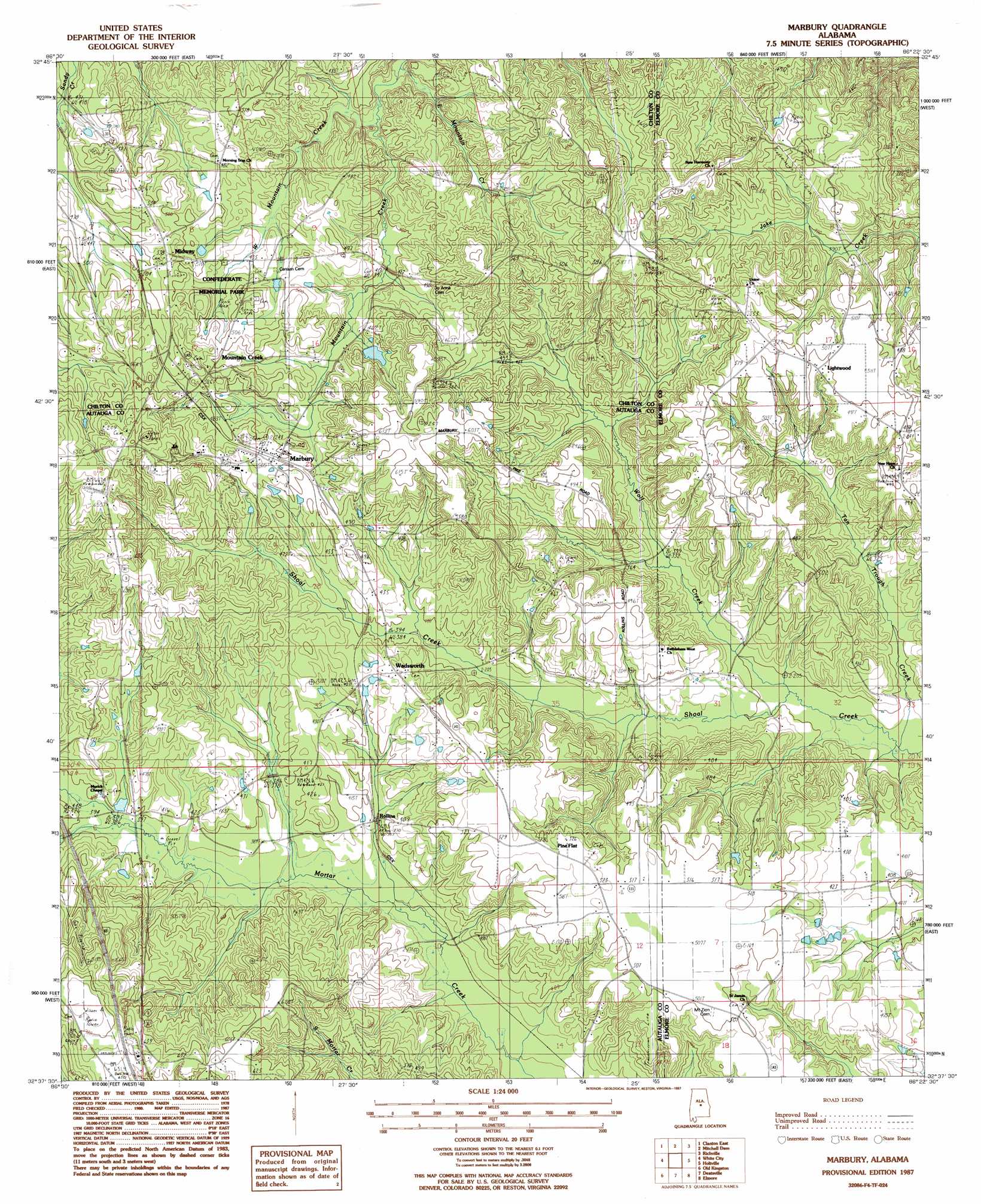
Marbury Topo Map Alabama
To zoom in, hover over the map of Marbury
USGS Topo Quad 32086f4 - 1:24,000 scale
| Topo Map Name: | Marbury |
| USGS Topo Quad ID: | 32086f4 |
| Print Size: | ca. 21 1/4" wide x 27" high |
| Southeast Coordinates: | 32.625° N latitude / 86.375° W longitude |
| Map Center Coordinates: | 32.6875° N latitude / 86.4375° W longitude |
| U.S. State: | AL |
| Filename: | o32086f4.jpg |
| Download Map JPG Image: | Marbury topo map 1:24,000 scale |
| Map Type: | Topographic |
| Topo Series: | 7.5´ |
| Map Scale: | 1:24,000 |
| Source of Map Images: | United States Geological Survey (USGS) |
| Alternate Map Versions: |
Marbury AL 1987, updated 1987 Download PDF Buy paper map Marbury AL 2011 Download PDF Buy paper map Marbury AL 2014 Download PDF Buy paper map |
1:24,000 Topo Quads surrounding Marbury
Jemison East |
Lay Dam |
Mitchell Dam Nw |
Flag Mountain |
Rockford |
Clanton West |
Clanton East |
Mitchell Dam |
Richville |
Rockford Sw |
Billingsley |
White City |
Marbury |
Holtville |
Dexter |
Vida |
Old Kingston |
Deatsville |
Elmore |
Wetumpka |
Autaugaville |
Forester |
Prattville |
Montgomery North |
Willow Springs |
> Back to 32086e1 at 1:100,000 scale
> Back to 32086a1 at 1:250,000 scale
> Back to U.S. Topo Maps home
Marbury topo map: Gazetteer
Marbury: Dams
Lightfoot Dam elevation 141m 462′Marbury: Parks
Confederate Memorial Park elevation 161m 528′Marbury: Populated Places
Lightwood elevation 149m 488′Marbury elevation 159m 521′
Midway elevation 163m 534′
Mountain Creek elevation 161m 528′
Pine Flat elevation 159m 521′
Pyron elevation 199m 652′
Rollins elevation 116m 380′
Wadsworth elevation 139m 456′
Wilder Hill (historical) elevation 222m 728′
Marbury: Post Offices
Marbury Post Office elevation 157m 515′Marbury: Reservoirs
Lightfoot Lake elevation 141m 462′Marbury: Streams
Mountain Creek elevation 115m 377′West Mountain Creek elevation 106m 347′
Wolf Creek elevation 88m 288′
Marbury digital topo map on disk
Buy this Marbury topo map showing relief, roads, GPS coordinates and other geographical features, as a high-resolution digital map file on DVD:
Gulf Coast (LA, MS, AL, FL) & Southwestern Georgia
Buy digital topo maps: Gulf Coast (LA, MS, AL, FL) & Southwestern Georgia
 & Southwestern Georgia map DVD")