Mitchell Dam Topo Map Alabama
To zoom in, hover over the map of Mitchell Dam
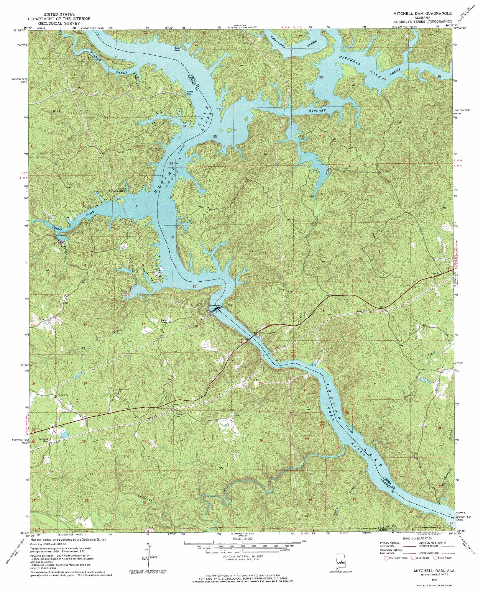
USGS Topo Quad 32086g4 - 1:24,000 scale
| Topo Map Name: | Mitchell Dam |
| USGS Topo Quad ID: | 32086g4 |
| Print Size: | ca. 21 1/4" wide x 27" high |
| Southeast Coordinates: | 32.75° N latitude / 86.375° W longitude |
| Map Center Coordinates: | 32.8125° N latitude / 86.4375° W longitude |
| U.S. State: | AL |
| Filename: | o32086g4.jpg |
| Download Map JPG Image: | Mitchell Dam topo map 1:24,000 scale |
| Map Type: | Topographic |
| Topo Series: | 7.5´ |
| Map Scale: | 1:24,000 |
| Source of Map Images: | United States Geological Survey (USGS) |
| Alternate Map Versions: |
Mitchell Dam AL 1971, updated 1973 Download PDF Buy paper map Mitchell Dam AL 1971, updated 1973 Download PDF Buy paper map Mitchell Dam AL 2011 Download PDF Buy paper map Mitchell Dam AL 2014 Download PDF Buy paper map |
1:24,000 Topo Quads surrounding Mitchell Dam
Ozan |
Shelby |
Talladega Springs |
Weogufka |
Hollins |
Jemison East |
Lay Dam |
Mitchell Dam Nw |
Flag Mountain |
Rockford |
Clanton West |
Clanton East |
Mitchell Dam |
Richville |
Rockford Sw |
Billingsley |
White City |
Marbury |
Holtville |
Dexter |
Vida |
Old Kingston |
Deatsville |
Elmore |
Wetumpka |
> Back to 32086e1 at 1:100,000 scale
> Back to 32086a1 at 1:250,000 scale
> Back to U.S. Topo Maps home
Mitchell Dam topo map: Gazetteer
Mitchell Dam: Crossings
Higgins Ferry (historical) elevation 95m 311′Houses Ferry (historical) elevation 95m 311′
Knights Ferry (historical) elevation 77m 252′
Mitchell Dam: Dams
Livingston Lake Dam elevation 107m 351′Mitchell Dam elevation 94m 308′
Woodward Lake Dam elevation 131m 429′
Mitchell Dam: Islands
Big Island (historical) elevation 95m 311′Goat Island elevation 98m 321′
Houses Island elevation 95m 311′
Mitchell Dam: Reservoirs
Livingston Lake elevation 107m 351′Mitchell Lake elevation 94m 308′
Woodward Lake elevation 131m 429′
Mitchell Dam: Streams
Bird Creek elevation 95m 311′Blue Creek elevation 95m 311′
Cargle Creek elevation 95m 311′
Chestnut Creek elevation 77m 252′
Hatchet Creek elevation 95m 311′
Mountain Creek elevation 100m 328′
Noneless Creek elevation 95m 311′
Pennymotley Creek elevation 95m 311′
Pinchoulee Creek elevation 77m 252′
Pollis Creek elevation 77m 252′
Proctor Creek elevation 79m 259′
Sandy Creek elevation 116m 380′
Walnut Creek elevation 95m 311′
Weogufka Creek elevation 95m 311′
Mitchell Dam digital topo map on disk
Buy this Mitchell Dam topo map showing relief, roads, GPS coordinates and other geographical features, as a high-resolution digital map file on DVD:
Gulf Coast (LA, MS, AL, FL) & Southwestern Georgia
Buy digital topo maps: Gulf Coast (LA, MS, AL, FL) & Southwestern Georgia
 & Southwestern Georgia map DVD")