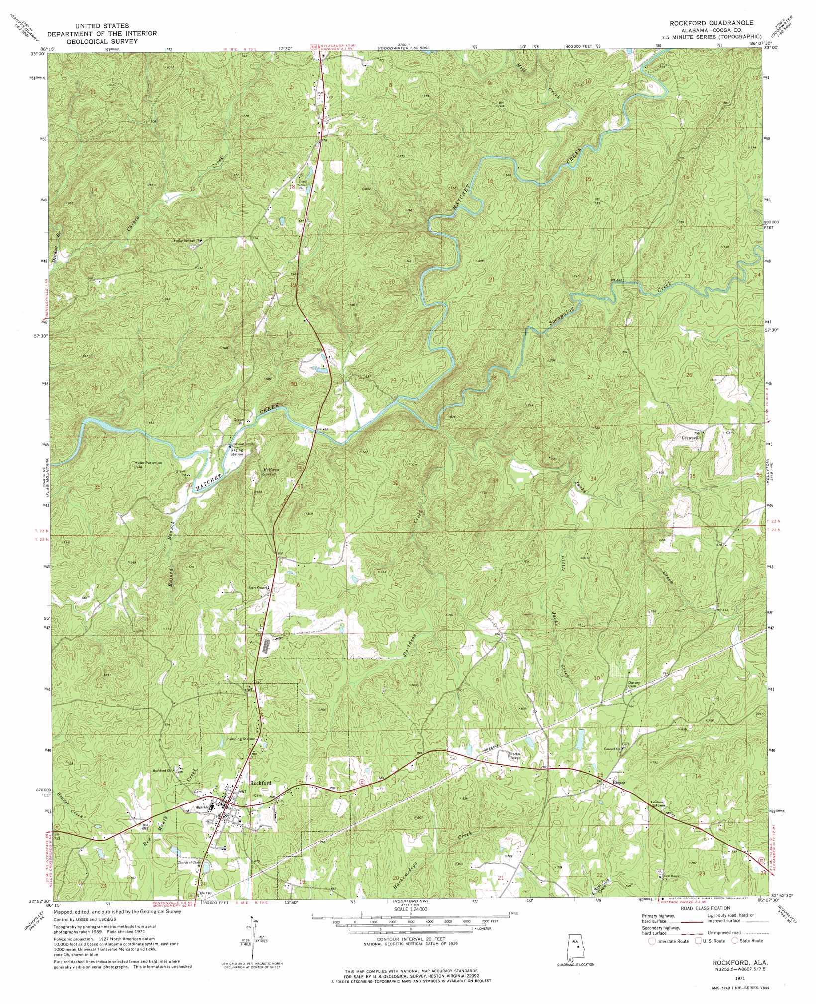
Rockford Topo Map Alabama
To zoom in, hover over the map of Rockford
USGS Topo Quad 32086h2 - 1:24,000 scale
| Topo Map Name: | Rockford |
| USGS Topo Quad ID: | 32086h2 |
| Print Size: | ca. 21 1/4" wide x 27" high |
| Southeast Coordinates: | 32.875° N latitude / 86.125° W longitude |
| Map Center Coordinates: | 32.9375° N latitude / 86.1875° W longitude |
| U.S. State: | AL |
| Filename: | o32086h2.jpg |
| Download Map JPG Image: | Rockford topo map 1:24,000 scale |
| Map Type: | Topographic |
| Topo Series: | 7.5´ |
| Map Scale: | 1:24,000 |
| Source of Map Images: | United States Geological Survey (USGS) |
| Alternate Map Versions: |
Rockford AL 1971, updated 1973 Download PDF Buy paper map Rockford AL 1971, updated 1977 Download PDF Buy paper map Rockford AL 2011 Download PDF Buy paper map Rockford AL 2014 Download PDF Buy paper map |
1:24,000 Topo Quads surrounding Rockford
Wilsonville |
Sylacauga West |
Sylacauga East |
Bulls Gap |
Millerville |
Talladega Springs |
Weogufka |
Hollins |
Goodwater |
Hackneyville |
Mitchell Dam Nw |
Flag Mountain |
Rockford |
Kellyton |
Alexander City |
Mitchell Dam |
Richville |
Rockford Sw |
Equality |
Our Town |
Marbury |
Holtville |
Dexter |
Eclectic |
Red Hill |
> Back to 32086e1 at 1:100,000 scale
> Back to 32086a1 at 1:250,000 scale
> Back to U.S. Topo Maps home
Rockford topo map: Gazetteer
Rockford: Dams
Elmer Dunnam Dam elevation 181m 593′J S Dunlap Dam elevation 226m 741′
Rockford: Mines
Thomas Prospect elevation 222m 728′Rockford: Populated Places
Crewsville elevation 227m 744′Hissop elevation 242m 793′
Rockford elevation 225m 738′
Rockford: Post Offices
Hissop Post Office elevation 242m 793′Rockford Post Office elevation 219m 718′
Rockford: Reservoirs
Dunlaps Lake elevation 233m 764′Howards Pond elevation 235m 770′
Rockford: Springs
McEwen Spring elevation 203m 666′Rockford: Streams
Buford Branch elevation 127m 416′Davidson Creek elevation 154m 505′
Jacks Creek elevation 137m 449′
Little Jacks Creek elevation 152m 498′
Meadow Branch elevation 144m 472′
Mill Creek elevation 158m 518′
Socapatoy Creek elevation 140m 459′
Rockford digital topo map on disk
Buy this Rockford topo map showing relief, roads, GPS coordinates and other geographical features, as a high-resolution digital map file on DVD:
Gulf Coast (LA, MS, AL, FL) & Southwestern Georgia
Buy digital topo maps: Gulf Coast (LA, MS, AL, FL) & Southwestern Georgia
 & Southwestern Georgia map DVD")