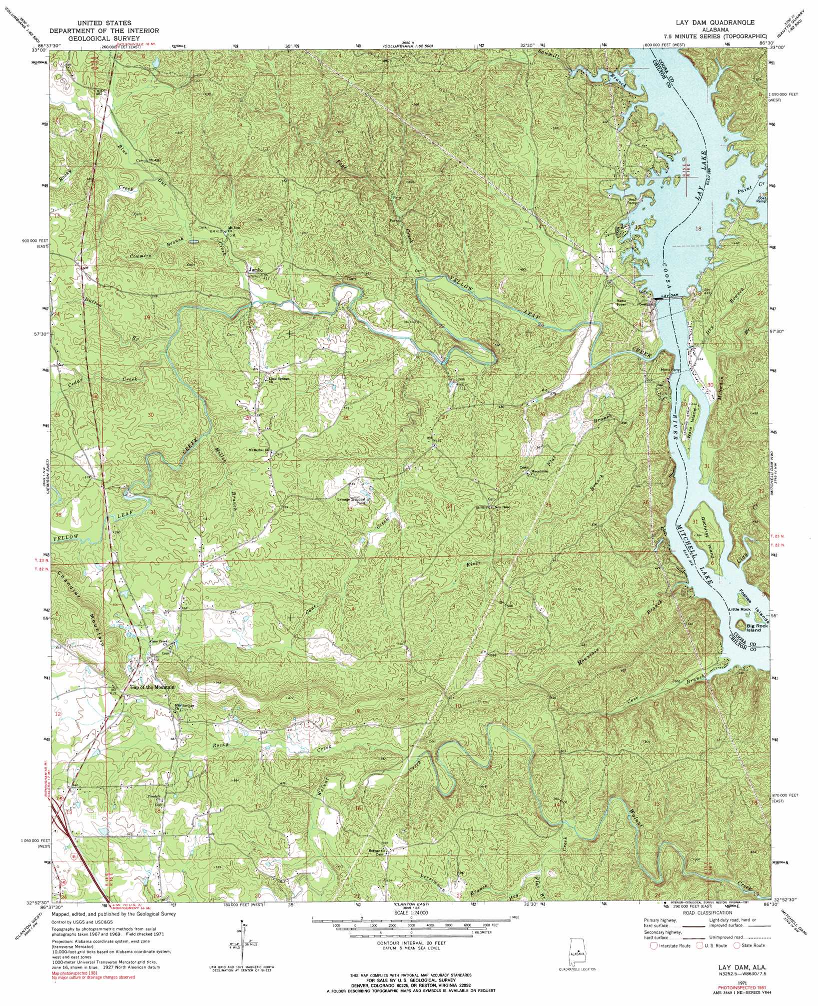
Lay Dam Topo Map Alabama
To zoom in, hover over the map of Lay Dam
USGS Topo Quad 32086h5 - 1:24,000 scale
| Topo Map Name: | Lay Dam |
| USGS Topo Quad ID: | 32086h5 |
| Print Size: | ca. 21 1/4" wide x 27" high |
| Southeast Coordinates: | 32.875° N latitude / 86.5° W longitude |
| Map Center Coordinates: | 32.9375° N latitude / 86.5625° W longitude |
| U.S. State: | AL |
| Filename: | o32086h5.jpg |
| Download Map JPG Image: | Lay Dam topo map 1:24,000 scale |
| Map Type: | Topographic |
| Topo Series: | 7.5´ |
| Map Scale: | 1:24,000 |
| Source of Map Images: | United States Geological Survey (USGS) |
| Alternate Map Versions: |
Lay Dam AL 1971, updated 1974 Download PDF Buy paper map Lay Dam AL 1971, updated 1991 Download PDF Buy paper map Lay Dam AL 2011 Download PDF Buy paper map Lay Dam AL 2014 Download PDF Buy paper map |
1:24,000 Topo Quads surrounding Lay Dam
Alabaster |
Bounds Lake |
Columbiana |
Wilsonville |
Sylacauga West |
Montevallo |
Ozan |
Shelby |
Talladega Springs |
Weogufka |
Jemison West |
Jemison East |
Lay Dam |
Mitchell Dam Nw |
Flag Mountain |
Maplesville East |
Clanton West |
Clanton East |
Mitchell Dam |
Richville |
Pletcher |
Billingsley |
White City |
Marbury |
Holtville |
> Back to 32086e1 at 1:100,000 scale
> Back to 32086a1 at 1:250,000 scale
> Back to U.S. Topo Maps home
Lay Dam topo map: Gazetteer
Lay Dam: Airports
Ware Island Airport elevation 104m 341′Lay Dam: Bars
Butting Ram Shoals elevation 95m 311′Lay Dam: Crossings
Interchange 212 elevation 201m 659′Mims Ferry elevation 95m 311′
Pages Old Ferry (historical) elevation 119m 390′
Lay Dam: Dams
Lay Dam elevation 119m 390′Lock Twelve (historical) elevation 99m 324′
Lay Dam: Islands
Big Rock Island elevation 130m 426′Cedar Island (historical) elevation 119m 390′
Foshee Islands elevation 97m 318′
Gilchrist Island elevation 110m 360′
Little Rock Island elevation 95m 311′
The Negrohead (historical) elevation 119m 390′
Ware Island elevation 104m 341′
Lay Dam: Mines
Maddox Mine elevation 180m 590′Old Maddox Mine elevation 187m 613′
Lay Dam: Populated Places
Gap of the Mountain elevation 172m 564′Jumbo elevation 123m 403′
Lay Dam: Reservoirs
Lay Lake elevation 119m 390′Lay Dam: Streams
Blue Gut Creek elevation 117m 383′Cane Creek elevation 114m 374′
Cane Creek elevation 110m 360′
Cedar Creek elevation 135m 442′
Clay Creek elevation 95m 311′
Cove Branch elevation 95m 311′
Cowmire Branch elevation 123m 403′
Dry Branch elevation 95m 311′
Dutton Branch elevation 132m 433′
Flat Branch elevation 100m 328′
Flat Branch elevation 138m 452′
Hog Creek elevation 130m 426′
McSwain Branch elevation 96m 314′
Miller Branch elevation 140m 459′
Mountain Branch elevation 95m 311′
Page Creek elevation 105m 344′
Paint Creek elevation 119m 390′
Persimmon Branch elevation 144m 472′
River Branch elevation 96m 314′
Rocky Creek elevation 147m 482′
Rocky Creek elevation 128m 419′
Sawmill Branch elevation 119m 390′
Yellow Leaf Creek elevation 95m 311′
Lay Dam digital topo map on disk
Buy this Lay Dam topo map showing relief, roads, GPS coordinates and other geographical features, as a high-resolution digital map file on DVD:
Gulf Coast (LA, MS, AL, FL) & Southwestern Georgia
Buy digital topo maps: Gulf Coast (LA, MS, AL, FL) & Southwestern Georgia
 & Southwestern Georgia map DVD")