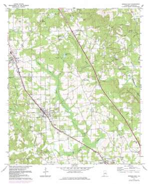
Jemison East Topo Map Alabama
To zoom in, hover over the map of Jemison East
USGS Topo Quad 32086h6 - 1:24,000 scale
| Topo Map Name: | Jemison East |
| USGS Topo Quad ID: | 32086h6 |
| Print Size: | ca. 21 1/4" wide x 27" high |
| Southeast Coordinates: | 32.875° N latitude / 86.625° W longitude |
| Map Center Coordinates: | 32.9375° N latitude / 86.6875° W longitude |
| U.S. State: | AL |
| Filename: | o32086h6.jpg |
| Download Map JPG Image: | Jemison East topo map 1:24,000 scale |
| Map Type: | Topographic |
| Topo Series: | 7.5´ |
| Map Scale: | 1:24,000 |
| Source of Map Images: | United States Geological Survey (USGS) |
| Alternate Map Versions: |
Jemison East AL 1971, updated 1974 Download PDF Buy paper map Jemison East AL 1971, updated 1984 Download PDF Buy paper map Jemison East AL 2011 Download PDF Buy paper map Jemison East AL 2014 Download PDF Buy paper map |
1:24,000 Topo Quads surrounding Jemison East
> Back to 32086e1 at 1:100,000 scale
> Back to 32086a1 at 1:250,000 scale
> Back to U.S. Topo Maps home
Jemison East topo map: Gazetteer
Jemison East: Crossings
Interchange 219 elevation 232m 761′Jemison East: Dams
Lake Fountain Head Dam elevation 214m 702′Lake John Paul Dam elevation 200m 656′
Luby Gore Dam elevation 197m 646′
Jemison East: Parks
Alabama Music Park elevation 222m 728′Susan Bentley Field elevation 202m 662′
Jemison East: Populated Places
Collins Chapel elevation 221m 725′Jemison elevation 219m 718′
Lomax elevation 199m 652′
Mineral Springs elevation 191m 626′
Rocky Mount elevation 209m 685′
Thorsby elevation 212m 695′
Union Grove elevation 233m 764′
Jemison East: Post Offices
Mullins Mill Post Office (historical) elevation 188m 616′Jemison East: Reservoirs
Bentleys Lake elevation 184m 603′Fountainhead Lake elevation 209m 685′
Lake John Paul elevation 200m 656′
Luby Gore Lake elevation 197m 646′
Jemison East: Ridges
Chandler Mountain elevation 254m 833′Jemison East: Streams
Cedar Grove Branch elevation 162m 531′Charlotte Creek elevation 161m 528′
Pate Creek elevation 178m 583′
Pig Pen Creek elevation 191m 626′
Ram Branch elevation 178m 583′
Turkey Creek elevation 167m 547′
Varden Branch elevation 139m 456′
Jemison East: Swamps
Gum Swamp elevation 183m 600′Jemison East digital topo map on disk
Buy this Jemison East topo map showing relief, roads, GPS coordinates and other geographical features, as a high-resolution digital map file on DVD:
Gulf Coast (LA, MS, AL, FL) & Southwestern Georgia
Buy digital topo maps: Gulf Coast (LA, MS, AL, FL) & Southwestern Georgia


