Randolph Topo Map Alabama
To zoom in, hover over the map of Randolph
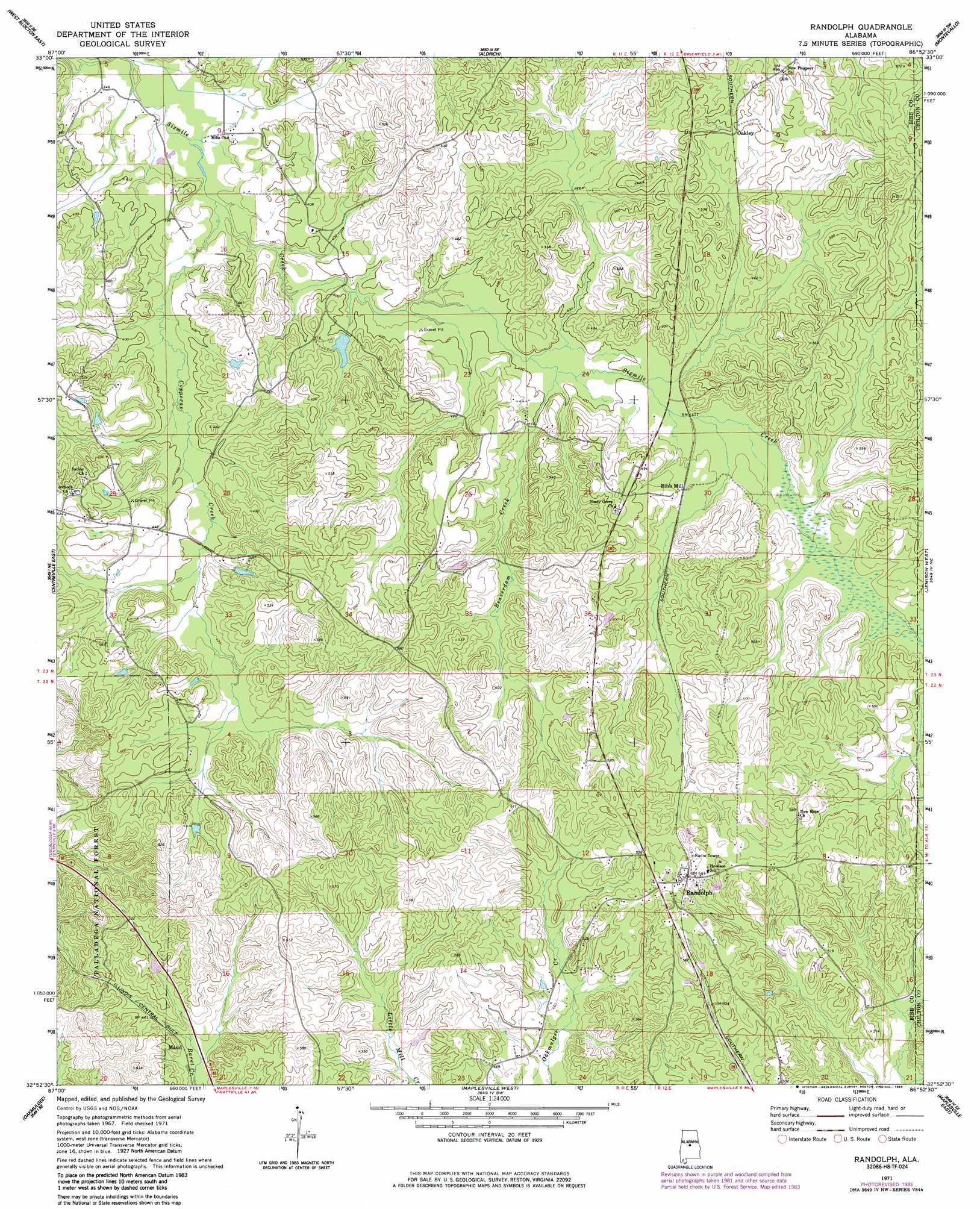
USGS Topo Quad 32086h8 - 1:24,000 scale
| Topo Map Name: | Randolph |
| USGS Topo Quad ID: | 32086h8 |
| Print Size: | ca. 21 1/4" wide x 27" high |
| Southeast Coordinates: | 32.875° N latitude / 86.875° W longitude |
| Map Center Coordinates: | 32.9375° N latitude / 86.9375° W longitude |
| U.S. State: | AL |
| Filename: | o32086h8.jpg |
| Download Map JPG Image: | Randolph topo map 1:24,000 scale |
| Map Type: | Topographic |
| Topo Series: | 7.5´ |
| Map Scale: | 1:24,000 |
| Source of Map Images: | United States Geological Survey (USGS) |
| Alternate Map Versions: |
Randolph AL 1971, updated 1974 Download PDF Buy paper map Randolph AL 1971, updated 1985 Download PDF Buy paper map Randolph AL 2002, updated 2003 Download PDF Buy paper map Randolph AL 2011 Download PDF Buy paper map Randolph AL 2014 Download PDF Buy paper map |
| FStopo: | US Forest Service topo Randolph is available: Download FStopo PDF Download FStopo TIF |
1:24,000 Topo Quads surrounding Randolph
Woodstock |
Halfmile Shoals |
Pea Ridge |
Alabaster |
Bounds Lake |
West Blocton West |
West Blocton East |
Aldrich |
Montevallo |
Ozan |
Centreville West |
Centreville East |
Randolph |
Jemison West |
Jemison East |
Harrisburg |
Oakmulgee |
Maplesville West |
Maplesville East |
Clanton West |
Sprott |
Buck Creek |
Plantersville |
Pletcher |
Billingsley |
> Back to 32086e1 at 1:100,000 scale
> Back to 32086a1 at 1:250,000 scale
> Back to U.S. Topo Maps home
Randolph topo map: Gazetteer
Randolph: Dams
Hammermill Paper Company Lake Dam elevation 118m 387′Randolph: Forests
Talladega National Forest elevation 160m 524′Randolph: Populated Places
Antioch elevation 164m 538′Bibb Mill elevation 138m 452′
Maud elevation 135m 442′
Oakley elevation 152m 498′
Randolph elevation 169m 554′
Thomas Mill elevation 122m 400′
Tucker elevation 153m 501′
Randolph: Post Offices
Randolph Post Office elevation 170m 557′Randolph: Reservoirs
Hammermill Paper Company Lake elevation 118m 387′Randolph: Streams
Beaverdam Creek elevation 120m 393′Copperas Creek elevation 109m 357′
Smelly Creek elevation 114m 374′
Randolph digital topo map on disk
Buy this Randolph topo map showing relief, roads, GPS coordinates and other geographical features, as a high-resolution digital map file on DVD:
Gulf Coast (LA, MS, AL, FL) & Southwestern Georgia
Buy digital topo maps: Gulf Coast (LA, MS, AL, FL) & Southwestern Georgia
 & Southwestern Georgia map DVD")