Lee Long Bridge Topo Map Alabama
To zoom in, hover over the map of Lee Long Bridge
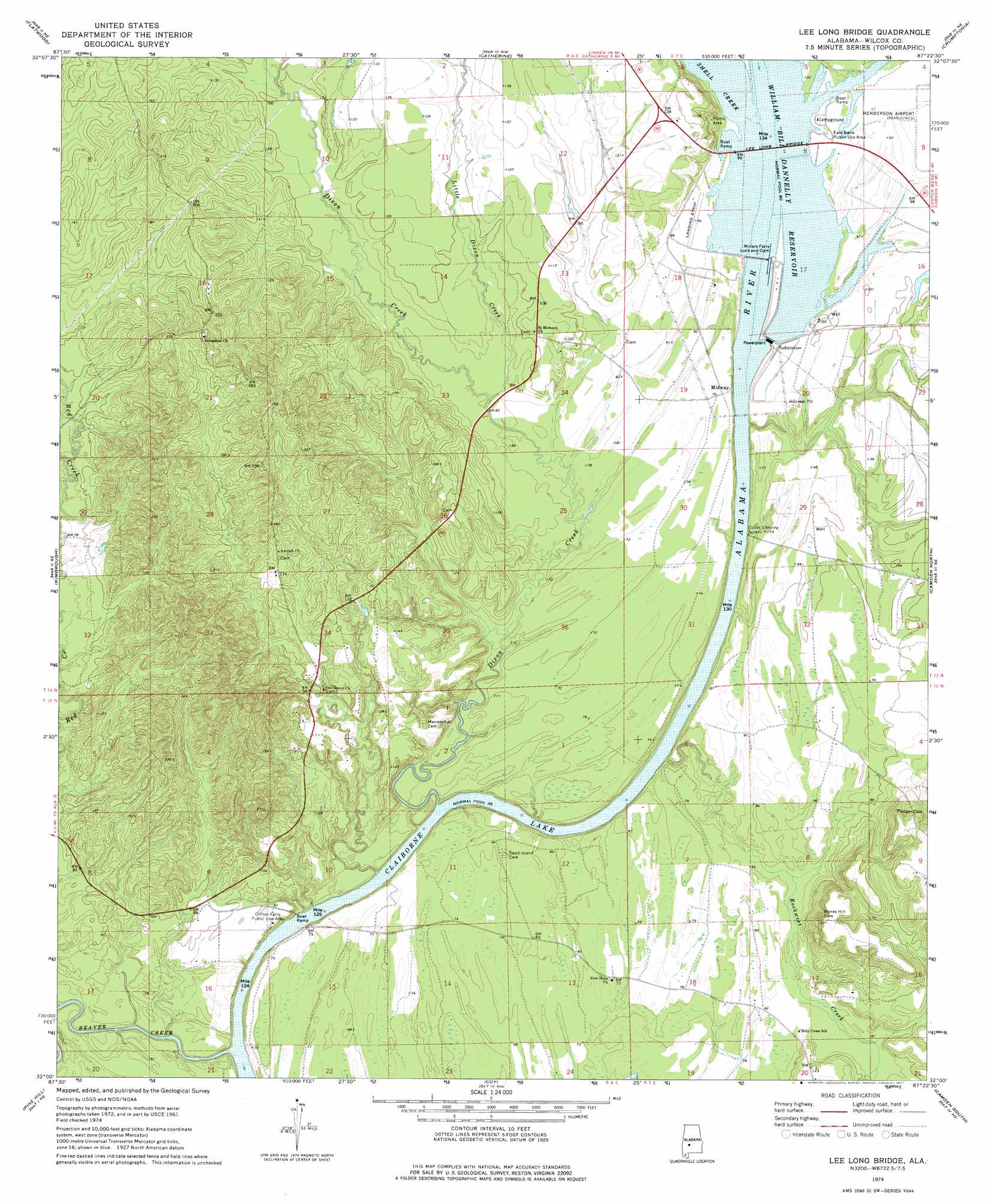
USGS Topo Quad 32087a4 - 1:24,000 scale
| Topo Map Name: | Lee Long Bridge |
| USGS Topo Quad ID: | 32087a4 |
| Print Size: | ca. 21 1/4" wide x 27" high |
| Southeast Coordinates: | 32° N latitude / 87.375° W longitude |
| Map Center Coordinates: | 32.0625° N latitude / 87.4375° W longitude |
| U.S. State: | AL |
| Filename: | o32087a4.jpg |
| Download Map JPG Image: | Lee Long Bridge topo map 1:24,000 scale |
| Map Type: | Topographic |
| Topo Series: | 7.5´ |
| Map Scale: | 1:24,000 |
| Source of Map Images: | United States Geological Survey (USGS) |
| Alternate Map Versions: |
Lee Long Bridge AL 1974, updated 1977 Download PDF Buy paper map Lee Long Bridge AL 2011 Download PDF Buy paper map Lee Long Bridge AL 2014 Download PDF Buy paper map |
1:24,000 Topo Quads surrounding Lee Long Bridge
Thomaston West |
Thomaston East |
Central Mills |
Safford |
Orrville |
Magnolia |
Flatwood |
Catherine |
Crumptonia |
Tasso |
Surginer |
Kimbrough |
Lee Long Bridge |
Camden North |
Tilden |
Thomasville |
Pine Hill |
Coy |
Camden South |
Rosebud |
Fulton East |
Lower Peach Tree |
Hybart |
Vredenburgh |
Nadawah |
> Back to 32087a1 at 1:100,000 scale
> Back to 32086a1 at 1:250,000 scale
> Back to U.S. Topo Maps home
Lee Long Bridge topo map: Gazetteer
Lee Long Bridge: Bars
Miller Ferry Bar (historical) elevation 24m 78′Lee Long Bridge: Bridges
Lee Long Bridge elevation 24m 78′Lee Long Bridge: Crossings
Clifton Ferry (historical) elevation 11m 36′Millers Ferry (historical) elevation 24m 78′
Pegues Ferry (historical) elevation 11m 36′
Lee Long Bridge: Dams
Henderson Lake Dam elevation 25m 82′Millers Ferry Lock and Dam elevation 11m 36′
Lee Long Bridge: Parks
Clifton Ferry Public Use Area elevation 28m 91′East Bank Public Use Area elevation 26m 85′
Shell Creek Park elevation 39m 127′
Lee Long Bridge: Populated Places
Midway elevation 23m 75′Lee Long Bridge: Reservoirs
Henderson Lake elevation 25m 82′William 'Bill' Dannelly Reservoir elevation 23m 75′
Lee Long Bridge: Streams
Beaver Creek elevation 11m 36′Dixon Creek elevation 18m 59′
Little Dixon Creek elevation 24m 78′
Little Red Creek elevation 24m 78′
Red Creek elevation 15m 49′
Rockwest Creek elevation 11m 36′
Shell Creek elevation 24m 78′
Slater Branch elevation 28m 91′
William Creek elevation 13m 42′
Lee Long Bridge digital topo map on disk
Buy this Lee Long Bridge topo map showing relief, roads, GPS coordinates and other geographical features, as a high-resolution digital map file on DVD:
Gulf Coast (LA, MS, AL, FL) & Southwestern Georgia
Buy digital topo maps: Gulf Coast (LA, MS, AL, FL) & Southwestern Georgia
 & Southwestern Georgia map DVD")