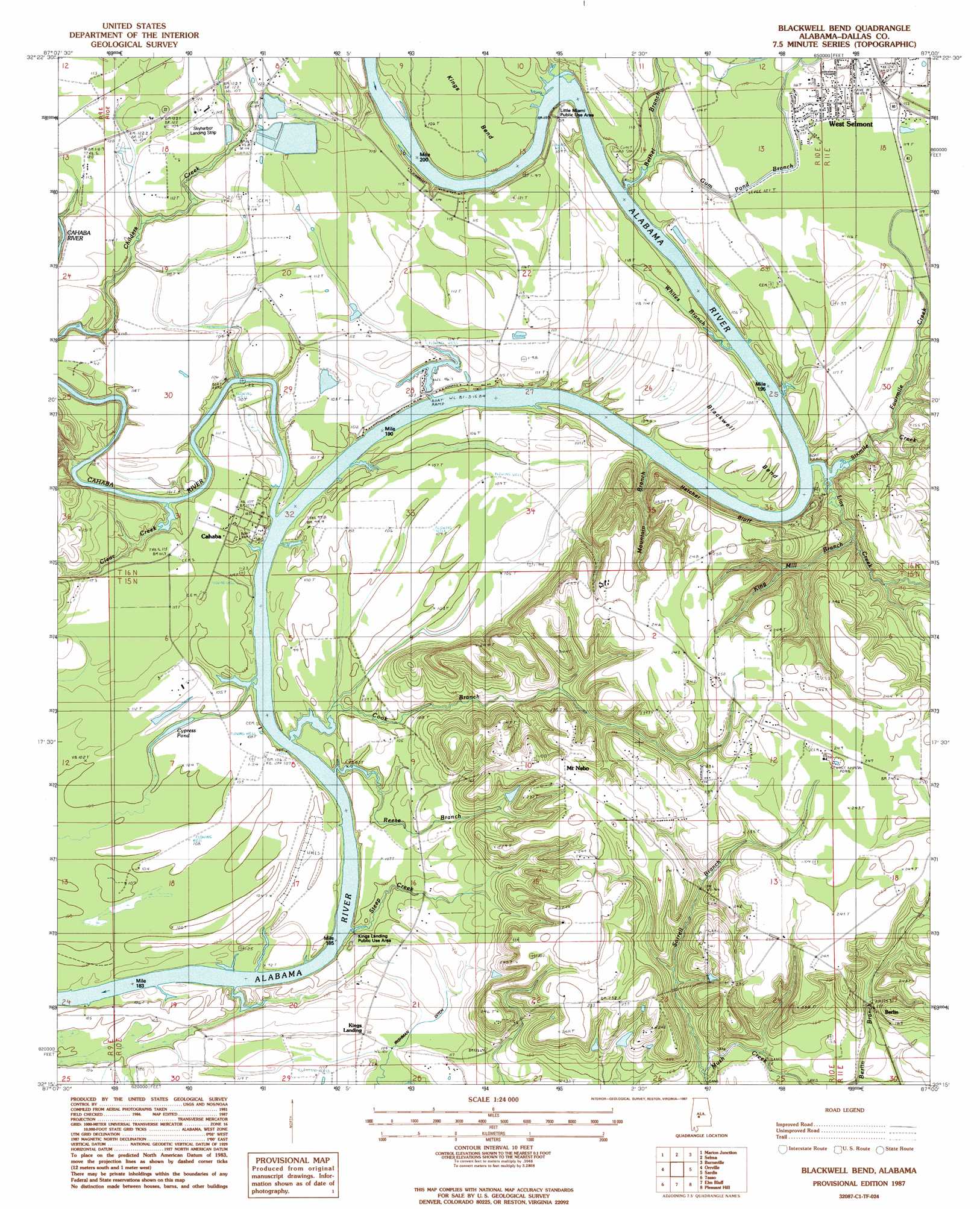
Blackwell Bend Topo Map Alabama
To zoom in, hover over the map of Blackwell Bend
USGS Topo Quad 32087c1 - 1:24,000 scale
| Topo Map Name: | Blackwell Bend |
| USGS Topo Quad ID: | 32087c1 |
| Print Size: | ca. 21 1/4" wide x 27" high |
| Southeast Coordinates: | 32.25° N latitude / 87° W longitude |
| Map Center Coordinates: | 32.3125° N latitude / 87.0625° W longitude |
| U.S. State: | AL |
| Filename: | o32087c1.jpg |
| Download Map JPG Image: | Blackwell Bend topo map 1:24,000 scale |
| Map Type: | Topographic |
| Topo Series: | 7.5´ |
| Map Scale: | 1:24,000 |
| Source of Map Images: | United States Geological Survey (USGS) |
| Alternate Map Versions: |
Selma SE AL 1975, updated 1977 Download PDF Buy paper map Blackwell Bend AL 1987, updated 1987 Download PDF Buy paper map Blackwell Bend AL 2011 Download PDF Buy paper map Blackwell Bend AL 2014 Download PDF Buy paper map |
1:24,000 Topo Quads surrounding Blackwell Bend
Marion South |
Suttle |
Summerfield |
Jones |
Milton |
Browns |
Marion Junction |
Selma |
Burnsville |
Durant Bend |
Safford |
Orrville |
Blackwell Bend |
Sardis |
Benton |
Crumptonia |
Tasso |
Elm Bluff |
Pleasant Hill |
Collirene |
Camden North |
Tilden |
Carlowville |
Minter |
Braggs |
> Back to 32087a1 at 1:100,000 scale
> Back to 32086a1 at 1:250,000 scale
> Back to U.S. Topo Maps home
Blackwell Bend topo map: Gazetteer
Blackwell Bend: Airports
Skyharbor Airport elevation 35m 114′Blackwell Bend: Bars
Cade Bar elevation 24m 78′King Bar elevation 24m 78′
Turkey Ford Bar elevation 24m 78′
Watts Bar elevation 24m 78′
Blackwell Bend: Bends
Blackwell Bend elevation 34m 111′Kings Bend elevation 31m 101′
Blackwell Bend: Canals
Irishman Ditch elevation 34m 111′Blackwell Bend: Cliffs
Hatcher Bluff elevation 25m 82′Kings Bluff elevation 31m 101′
Blackwell Bend: Dams
R L Mcdowell Dam elevation 24m 78′Blackwell Bend: Parks
Cahaba River Public Use Area elevation 35m 114′Kings Landing Public Use Area elevation 28m 91′
Little Miami Public Use Area elevation 32m 104′
Six Mile Creek Public Use Area elevation 28m 91′
Blackwell Bend: Populated Places
Berlin elevation 52m 170′Cahaba elevation 32m 104′
Mount Nebo elevation 72m 236′
Blackwell Bend: Reservoirs
Cypress Pond elevation 31m 101′Mcdowell Lake elevation 24m 78′
Blackwell Bend: Streams
Berlin Branch elevation 37m 121′Bethel Branch elevation 24m 78′
Big Ditch elevation 25m 82′
Cahaba River elevation 26m 85′
Clear Creek elevation 27m 88′
Cook Branch elevation 24m 78′
Fourmile Creek elevation 27m 88′
Gum Pond Branch elevation 26m 85′
King Mill Branch elevation 31m 101′
Lias Creek elevation 24m 78′
Mountain Branch elevation 24m 78′
Reese Branch elevation 24m 78′
Sixmile Creek elevation 24m 78′
Sorrell Branch elevation 34m 111′
State Place Branch elevation 24m 78′
Steep Creek elevation 24m 78′
Whites Branch elevation 24m 78′
Blackwell Bend digital topo map on disk
Buy this Blackwell Bend topo map showing relief, roads, GPS coordinates and other geographical features, as a high-resolution digital map file on DVD:
Gulf Coast (LA, MS, AL, FL) & Southwestern Georgia
Buy digital topo maps: Gulf Coast (LA, MS, AL, FL) & Southwestern Georgia
 & Southwestern Georgia map DVD")