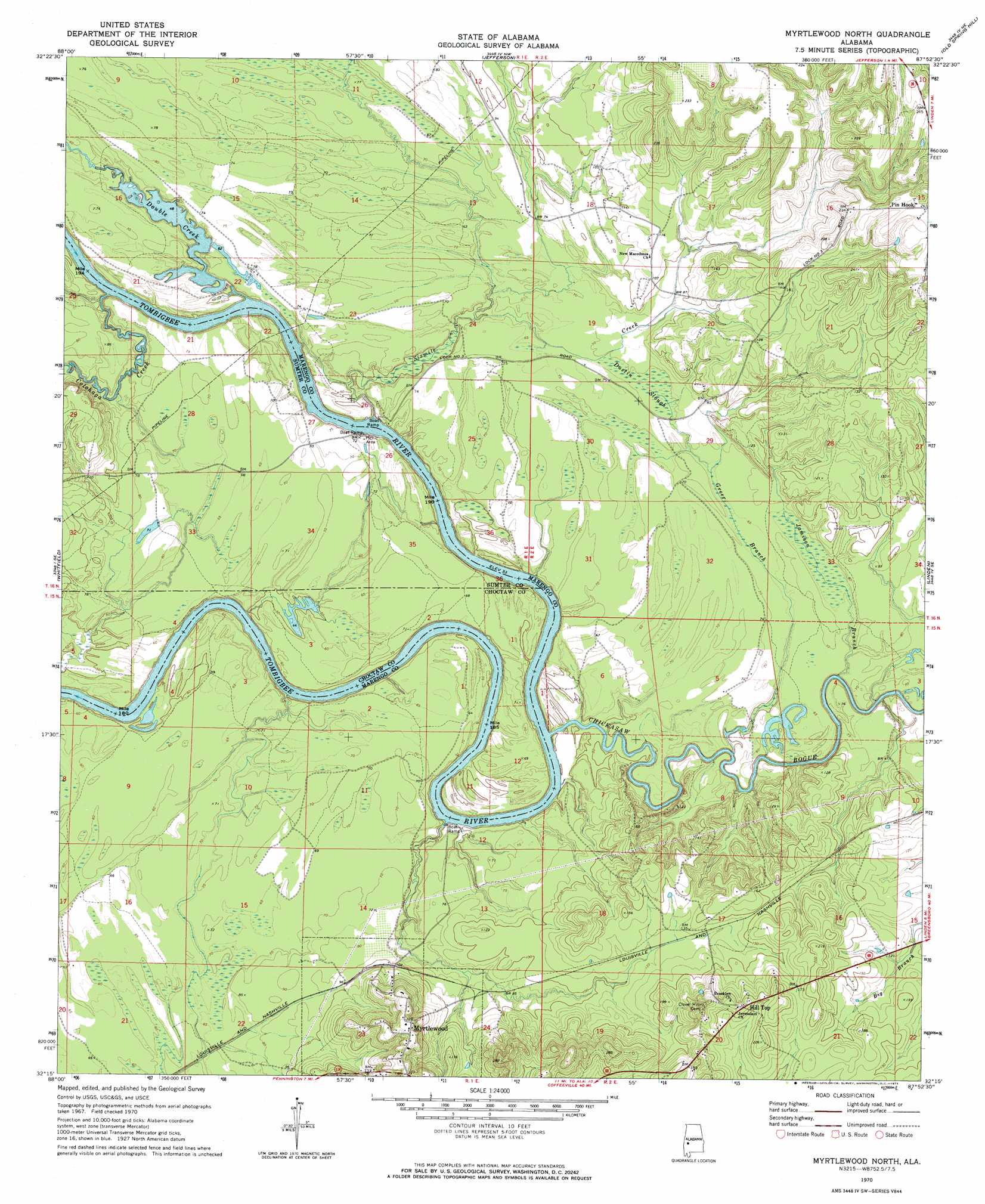
Myrtlewood North Topo Map Alabama
To zoom in, hover over the map of Myrtlewood North
USGS Topo Quad 32087c8 - 1:24,000 scale
| Topo Map Name: | Myrtlewood North |
| USGS Topo Quad ID: | 32087c8 |
| Print Size: | ca. 21 1/4" wide x 27" high |
| Southeast Coordinates: | 32.25° N latitude / 87.875° W longitude |
| Map Center Coordinates: | 32.3125° N latitude / 87.9375° W longitude |
| U.S. State: | AL |
| Filename: | o32087c8.jpg |
| Download Map JPG Image: | Myrtlewood North topo map 1:24,000 scale |
| Map Type: | Topographic |
| Topo Series: | 7.5´ |
| Map Scale: | 1:24,000 |
| Source of Map Images: | United States Geological Survey (USGS) |
| Alternate Map Versions: |
Myrtlewood North AL 1970, updated 1973 Download PDF Buy paper map Myrtlewood North AL 2011 Download PDF Buy paper map Myrtlewood North AL 2014 Download PDF Buy paper map |
1:24,000 Topo Quads surrounding Myrtlewood North
Livingston |
Brewersville |
Mcdowell |
Demopolis |
Casemore |
Bellamy |
Coatopa |
Jefferson |
Old Spring Hill |
Gallion |
Gaston |
Whitfield |
Myrtlewood North |
Linden |
Thomaston West |
Jachin |
Pennington |
Myrtlewood South |
Miller |
Magnolia |
Butler |
Putnam |
Nanafalia |
Sweet Water |
Surginer |
> Back to 32087a1 at 1:100,000 scale
> Back to 32086a1 at 1:250,000 scale
> Back to U.S. Topo Maps home
Myrtlewood North topo map: Gazetteer
Myrtlewood North: Bars
Beckleys Bar elevation 16m 52′Double Bar elevation 10m 32′
Four Mile Bar elevation 10m 32′
Lone Brothers Bar elevation 10m 32′
Miles Shoal elevation 10m 32′
Nick Lewis Bar elevation 10m 32′
Rainwater Bar elevation 19m 62′
Remberts Bar elevation 10m 32′
Robert Emmet Bar elevation 34m 111′
Myrtlewood North: Crossings
Rentz Ferry (historical) elevation 12m 39′Myrtlewood North: Guts
Dustin Slough elevation 21m 68′Myrtlewood North: Islands
Smith Island elevation 11m 36′Myrtlewood North: Parks
Lock Three Left Bank Public Use Area elevation 18m 59′Lock Three Right Bank Public Use Area elevation 21m 68′
Myrtlewood North: Populated Places
Beckleys (historical) elevation 22m 72′Blue Lock (historical) elevation 35m 114′
Cedahoma (historical) elevation 18m 59′
Griffins (historical) elevation 17m 55′
Hill Top elevation 66m 216′
McNeils (historical) elevation 21m 68′
Myrtlewood elevation 66m 216′
Myrtlewood North: Streams
Chickasaw Bogue elevation 13m 42′Cotohaga Creek elevation 10m 32′
Double Creek elevation 10m 32′
Greer Branch elevation 13m 42′
Indian Creek elevation 12m 39′
Jamison Branch elevation 18m 59′
Lost Creek elevation 10m 32′
Sixmile Creek elevation 13m 42′
Sixmile Creek elevation 15m 49′
Myrtlewood North digital topo map on disk
Buy this Myrtlewood North topo map showing relief, roads, GPS coordinates and other geographical features, as a high-resolution digital map file on DVD:
Gulf Coast (LA, MS, AL, FL) & Southwestern Georgia
Buy digital topo maps: Gulf Coast (LA, MS, AL, FL) & Southwestern Georgia
 & Southwestern Georgia map DVD")