Browns Topo Map Alabama
To zoom in, hover over the map of Browns
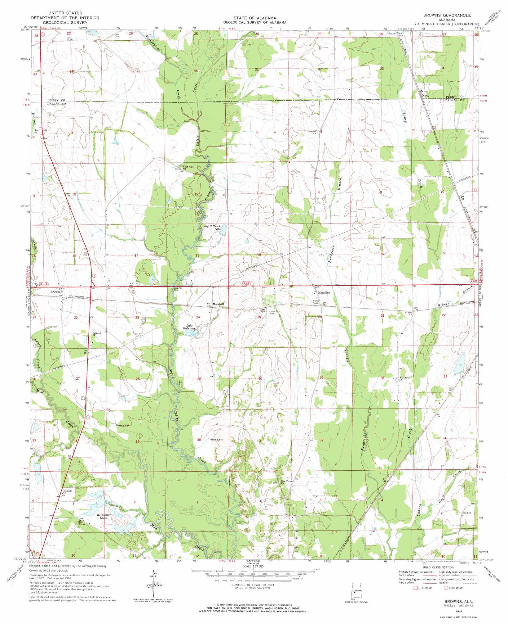
USGS Topo Quad 32087d3 - 1:24,000 scale
| Topo Map Name: | Browns |
| USGS Topo Quad ID: | 32087d3 |
| Print Size: | ca. 21 1/4" wide x 27" high |
| Southeast Coordinates: | 32.375° N latitude / 87.25° W longitude |
| Map Center Coordinates: | 32.4375° N latitude / 87.3125° W longitude |
| U.S. State: | AL |
| Filename: | o32087d3.jpg |
| Download Map JPG Image: | Browns topo map 1:24,000 scale |
| Map Type: | Topographic |
| Topo Series: | 7.5´ |
| Map Scale: | 1:24,000 |
| Source of Map Images: | United States Geological Survey (USGS) |
| Alternate Map Versions: |
Browns AL 1968, updated 1971 Download PDF Buy paper map Browns AL 2011 Download PDF Buy paper map Browns AL 2014 Download PDF Buy paper map |
1:24,000 Topo Quads surrounding Browns
Greensboro |
Morgan Springs |
Marion North |
Sprott |
Buck Creek |
Newbern |
Scott Station |
Marion South |
Suttle |
Summerfield |
Uniontown West |
Uniontown East |
Browns |
Marion Junction |
Selma |
Thomaston East |
Central Mills |
Safford |
Orrville |
Blackwell Bend |
Flatwood |
Catherine |
Crumptonia |
Tasso |
Elm Bluff |
> Back to 32087a1 at 1:100,000 scale
> Back to 32086a1 at 1:250,000 scale
> Back to U.S. Topo Maps home
Browns topo map: Gazetteer
Browns: Dams
C A Caines Lake Dam elevation 40m 131′E F Randell Dam elevation 53m 173′
F W Pierce Lake Dam Number 2 elevation 50m 164′
Marion Weissinger Lake Dam Number 2 elevation 43m 141′
W W Weissinger Number 2 Dam elevation 45m 147′
W W Weissinger Number 4 Dam elevation 50m 164′
W W Wesssinger Number 1 Dam elevation 43m 141′
Browns: Populated Places
Browns elevation 52m 170′Marshall elevation 55m 180′
Massillon elevation 59m 193′
Nave elevation 60m 196′
Browns: Reservoirs
Big B Ranch Lake elevation 52m 170′C A Caines Lake elevation 40m 131′
E F Randell Lake elevation 53m 173′
F W Pierce Lake Number 2 elevation 50m 164′
Lake Walnutta elevation 43m 141′
Marion Weissinger Lake Number 2 elevation 43m 141′
W W Weissinger Lake Number 1 elevation 43m 141′
W W Weissinger Number 2 Lake elevation 45m 147′
W W Weissinger Number 4 Lake elevation 50m 164′
Weissinger Lakes elevation 45m 147′
Browns: Streams
Brush Creek elevation 42m 137′Dry Creek elevation 42m 137′
Gilmer Branch elevation 48m 157′
Washington Creek elevation 46m 150′
Browns digital topo map on disk
Buy this Browns topo map showing relief, roads, GPS coordinates and other geographical features, as a high-resolution digital map file on DVD:
Gulf Coast (LA, MS, AL, FL) & Southwestern Georgia
Buy digital topo maps: Gulf Coast (LA, MS, AL, FL) & Southwestern Georgia
 & Southwestern Georgia map DVD")