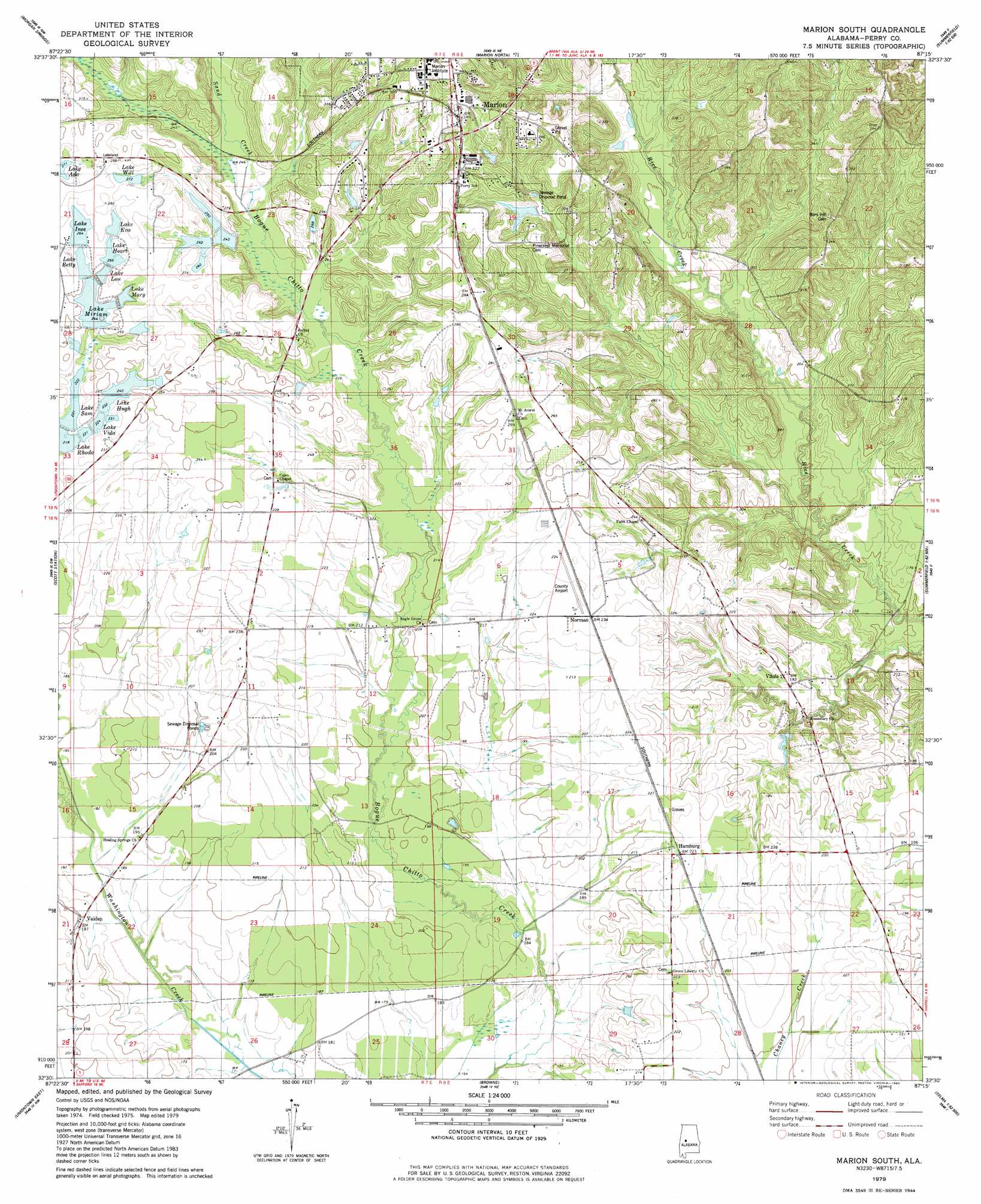
Marion South Topo Map Alabama
To zoom in, hover over the map of Marion South
USGS Topo Quad 32087e3 - 1:24,000 scale
| Topo Map Name: | Marion South |
| USGS Topo Quad ID: | 32087e3 |
| Print Size: | ca. 21 1/4" wide x 27" high |
| Southeast Coordinates: | 32.5° N latitude / 87.25° W longitude |
| Map Center Coordinates: | 32.5625° N latitude / 87.3125° W longitude |
| U.S. State: | AL |
| Filename: | o32087e3.jpg |
| Download Map JPG Image: | Marion South topo map 1:24,000 scale |
| Map Type: | Topographic |
| Topo Series: | 7.5´ |
| Map Scale: | 1:24,000 |
| Source of Map Images: | United States Geological Survey (USGS) |
| Alternate Map Versions: |
Marion South AL 1979, updated 1980 Download PDF Buy paper map Marion South AL 2011 Download PDF Buy paper map Marion South AL 2014 Download PDF Buy paper map |
1:24,000 Topo Quads surrounding Marion South
Ingram |
Hogglesville |
Heiberger |
Harrisburg |
Oakmulgee |
Greensboro |
Morgan Springs |
Marion North |
Sprott |
Buck Creek |
Newbern |
Scott Station |
Marion South |
Suttle |
Summerfield |
Uniontown West |
Uniontown East |
Browns |
Marion Junction |
Selma |
Thomaston East |
Central Mills |
Safford |
Orrville |
Blackwell Bend |
> Back to 32087e1 at 1:100,000 scale
> Back to 32086a1 at 1:250,000 scale
> Back to U.S. Topo Maps home
Marion South topo map: Gazetteer
Marion South: Airports
Perry County Airport (historical) elevation 65m 213′Marion South: Dams
C E Lee Dam elevation 76m 249′F W Pierce Lake Dam Number 1 elevation 73m 239′
Floyd Cook Dam elevation 94m 308′
Lakeland Farms Dam Number Eighteen elevation 83m 272′
Lakeland Farms Dam Number Eleven elevation 83m 272′
Lakeland Farms Dam Number Fifteen elevation 78m 255′
Lakeland Farms Dam Number Fourteen elevation 85m 278′
Lakeland Farms Dam Number Nine elevation 79m 259′
Lakeland Farms Dam Number One elevation 76m 249′
Lakeland Farms Dam Number Sixteen elevation 89m 291′
Lakeland Farms Dam Number Ten elevation 85m 278′
Lakeland Farms Dam Number Thirteen elevation 68m 223′
Lakeland Farms Dam Number Twelve elevation 67m 219′
W A Hughes Lake Dam elevation 75m 246′
Marion South: Populated Places
Hamburg elevation 68m 223′Norman elevation 72m 236′
Vaiden elevation 59m 193′
Vilula elevation 57m 187′
Marion South: Reservoirs
F W Pierce Lake Number One elevation 73m 239′Floyd Cook Lake elevation 94m 308′
Lake Betty elevation 76m 249′
Lake Eva elevation 81m 265′
Lake Heart elevation 78m 255′
Lake Hugh elevation 71m 232′
Lake Ines elevation 81m 265′
Lake Lou elevation 74m 242′
Lake Mary elevation 74m 242′
Lake Miriam elevation 75m 246′
Lake Sam elevation 68m 223′
Lake Vida elevation 68m 223′
Lake Will elevation 83m 272′
Lakeland Farms Pond Number Fifteen elevation 78m 255′
Lakeland Farms Pond Number Fourteen elevation 85m 278′
Lakeland Farms Pond Number Sixteen elevation 89m 291′
Lees Lake elevation 76m 249′
W A Hughes Lake elevation 75m 246′
Marion South: Streams
Sand Creek elevation 70m 229′Marion South digital topo map on disk
Buy this Marion South topo map showing relief, roads, GPS coordinates and other geographical features, as a high-resolution digital map file on DVD:
Gulf Coast (LA, MS, AL, FL) & Southwestern Georgia
Buy digital topo maps: Gulf Coast (LA, MS, AL, FL) & Southwestern Georgia
 & Southwestern Georgia map DVD")