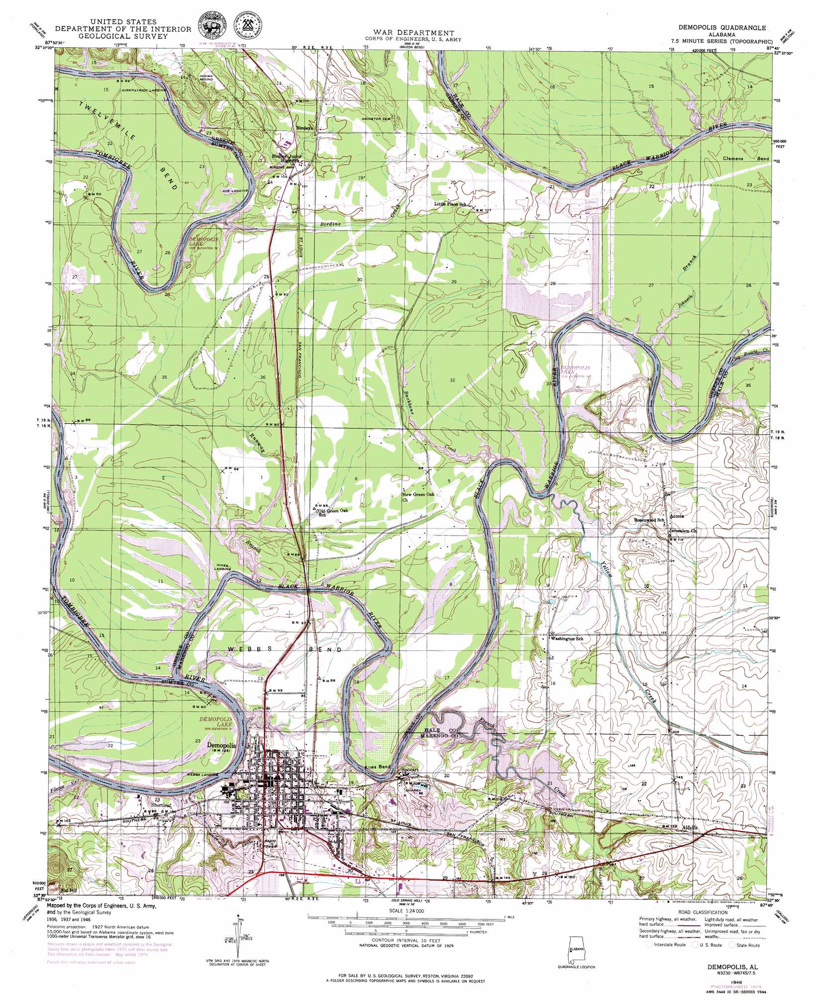
Demopolis Topo Map Alabama
To zoom in, hover over the map of Demopolis
USGS Topo Quad 32087e7 - 1:24,000 scale
| Topo Map Name: | Demopolis |
| USGS Topo Quad ID: | 32087e7 |
| Print Size: | ca. 21 1/4" wide x 27" high |
| Southeast Coordinates: | 32.5° N latitude / 87.75° W longitude |
| Map Center Coordinates: | 32.5625° N latitude / 87.8125° W longitude |
| U.S. State: | AL |
| Filename: | o32087e7.jpg |
| Download Map JPG Image: | Demopolis topo map 1:24,000 scale |
| Map Type: | Topographic |
| Topo Series: | 7.5´ |
| Map Scale: | 1:24,000 |
| Source of Map Images: | United States Geological Survey (USGS) |
| Alternate Map Versions: |
Demopolis AL 1946, updated 1979 Download PDF Buy paper map Demopolis AL 1946, updated 1984 Download PDF Buy paper map Demopolis AL 1947 Download PDF Buy paper map Demopolis AL 2011 Download PDF Buy paper map Demopolis AL 2014 Download PDF Buy paper map |
1:24,000 Topo Quads surrounding Demopolis
Boligee |
Eutaw |
Warrior Dam |
Sawyerville |
Ingram |
Epes East |
Forkland |
Mason Bend |
Melton |
Greensboro |
Brewersville |
Mcdowell |
Demopolis |
Casemore |
Newbern |
Coatopa |
Jefferson |
Old Spring Hill |
Gallion |
Uniontown West |
Whitfield |
Myrtlewood North |
Linden |
Thomaston West |
Thomaston East |
> Back to 32087e1 at 1:100,000 scale
> Back to 32086a1 at 1:250,000 scale
> Back to U.S. Topo Maps home
Demopolis topo map: Gazetteer
Demopolis: Bars
Birdine Bar elevation 23m 75′Coles Bar elevation 22m 72′
Hancocks Bar elevation 22m 72′
Haunted Point Bar elevation 22m 72′
Kirkpatricks Shoals elevation 25m 82′
Logyard Shoals elevation 22m 72′
McGuilons Bar elevation 23m 75′
Negro Heel Bar elevation 22m 72′
Taylors Bar elevation 22m 72′
Tubbs Bar elevation 22m 72′
Demopolis: Bends
Clemens Bend elevation 24m 78′Gadeous Bend elevation 23m 75′
Klies Bend elevation 23m 75′
Webbs Bend elevation 22m 72′
Demopolis: Canals
Whitfield Canal elevation 24m 78′Demopolis: Capes
Haunted Point elevation 23m 75′Demopolis: Channels
Kaintuck Chute elevation 22m 72′Demopolis: Crossings
Arcola Ferry (historical) elevation 26m 85′Baggers Ferry (historical) elevation 24m 78′
Garners Ferry (historical) elevation 22m 72′
Glovers Ferry (historical) elevation 22m 72′
Merryweathers Ferry (historical) elevation 22m 72′
Reddicks Ferry (historical) elevation 22m 72′
Rowes Ferry (historical) elevation 23m 75′
Tindells Ferry (historical) elevation 22m 72′
Demopolis: Dams
Demopolis Country Club Dam elevation 33m 108′Demopolis: Harbors
Demopolis Yacht Basin elevation 22m 72′Demopolis: Parks
Arcola Public Use Area elevation 25m 82′Backbone Branch Public Area elevation 25m 82′
Backbone Park elevation 22m 72′
Demopolis Access Area elevation 22m 72′
Demopolis Botanical Gardens elevation 23m 75′
Demopolis Public Square elevation 36m 118′
Foscue Creek Area elevation 22m 72′
Foscue Park elevation 28m 91′
French Creek Public Use Area elevation 24m 78′
Runaway Branch Area Number 1 elevation 24m 78′
Runaway Branch Area Number 2 elevation 24m 78′
Demopolis: Plains
The Fork elevation 26m 85′Demopolis: Populated Places
Alfalfa elevation 44m 144′Arcola elevation 39m 127′
Baptist Hill elevation 35m 114′
Birdeye elevation 31m 101′
Demopolis elevation 37m 121′
Knoxwood elevation 33m 108′
Rockcut elevation 35m 114′
Shortleaf elevation 30m 98′
Spocari elevation 31m 101′
Demopolis: Reservoirs
Demopolis Country Club Lake elevation 33m 108′Demopolis: Ridges
Beach Ridge elevation 37m 121′Demopolis: Streams
Backbone Creek elevation 22m 72′Big Prairie Creek elevation 23m 75′
Big Slough elevation 24m 78′
Birdine Creek elevation 22m 72′
Black Warrior River elevation 22m 72′
Brown Ridge Slough elevation 24m 78′
Foscue Creek elevation 22m 72′
French Creek elevation 22m 72′
Johnson Branch elevation 22m 72′
Lime Kiln Creek elevation 22m 72′
Negrofoot Branch elevation 22m 72′
Runway Branch elevation 22m 72′
Yellow Creek elevation 22m 72′
Demopolis: Summits
Kid Hill elevation 63m 206′Lamberths Mound elevation 44m 144′
Demopolis digital topo map on disk
Buy this Demopolis topo map showing relief, roads, GPS coordinates and other geographical features, as a high-resolution digital map file on DVD:
Gulf Coast (LA, MS, AL, FL) & Southwestern Georgia
Buy digital topo maps: Gulf Coast (LA, MS, AL, FL) & Southwestern Georgia
 & Southwestern Georgia map DVD")