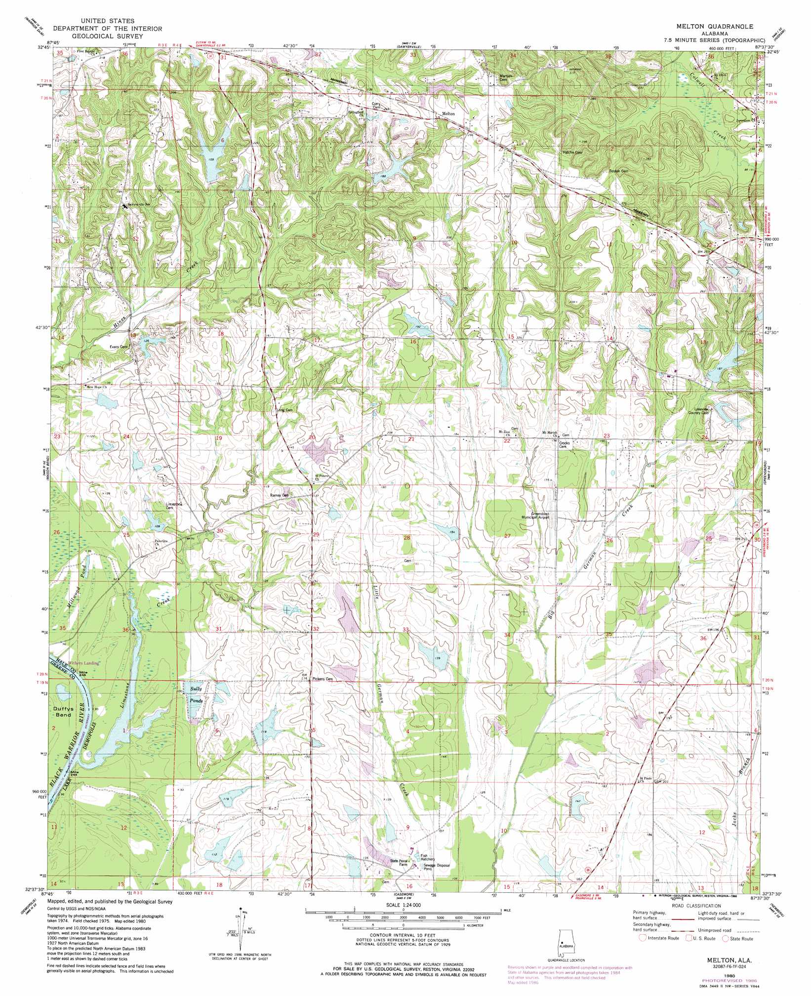
Melton Topo Map Alabama
To zoom in, hover over the map of Melton
USGS Topo Quad 32087f6 - 1:24,000 scale
| Topo Map Name: | Melton |
| USGS Topo Quad ID: | 32087f6 |
| Print Size: | ca. 21 1/4" wide x 27" high |
| Southeast Coordinates: | 32.625° N latitude / 87.625° W longitude |
| Map Center Coordinates: | 32.6875° N latitude / 87.6875° W longitude |
| U.S. State: | AL |
| Filename: | o32087f6.jpg |
| Download Map JPG Image: | Melton topo map 1:24,000 scale |
| Map Type: | Topographic |
| Topo Series: | 7.5´ |
| Map Scale: | 1:24,000 |
| Source of Map Images: | United States Geological Survey (USGS) |
| Alternate Map Versions: |
Melton AL 1980, updated 1980 Download PDF Buy paper map Melton AL 1980, updated 1986 Download PDF Buy paper map Melton AL 2011 Download PDF Buy paper map Melton AL 2014 Download PDF Buy paper map |
1:24,000 Topo Quads surrounding Melton
Union |
Knoxville |
Moundville West |
Moundville East |
Payne Lake |
Eutaw |
Warrior Dam |
Sawyerville |
Ingram |
Hogglesville |
Forkland |
Mason Bend |
Melton |
Greensboro |
Morgan Springs |
Mcdowell |
Demopolis |
Casemore |
Newbern |
Scott Station |
Jefferson |
Old Spring Hill |
Gallion |
Uniontown West |
Uniontown East |
> Back to 32087e1 at 1:100,000 scale
> Back to 32086a1 at 1:250,000 scale
> Back to U.S. Topo Maps home
Melton topo map: Gazetteer
Melton: Airports
Greensboro Municipal Airport elevation 52m 170′Melton: Bars
Limestone Creek Bar elevation 22m 72′Melton: Dams
Amos Bailey Dam elevation 59m 193′B W Coleman Dam Number 1 elevation 56m 183′
B W Coleman Dam Number 2 elevation 60m 196′
C H Bryars Junior Dam Number 1 elevation 37m 121′
C H Bryars Junior Dam Number 2 elevation 40m 131′
C H Bryars Junior Dam Number 3 elevation 30m 98′
Carey Tidmore Dam elevation 67m 219′
Jim Griffin Dam elevation 64m 209′
Jimmy Seale Dam elevation 47m 154′
John Jay Dam elevation 60m 196′
Lelia Myers Dam elevation 35m 114′
Limestone Lakes Dam Number 1 elevation 33m 108′
Limestone Lakes Dam Number 2 elevation 34m 111′
Morrison Brothers Dam elevation 38m 124′
Morrison Brothers Dam elevation 41m 134′
Richard Massey Dam elevation 65m 213′
Richard Poellnitz Dam elevation 39m 127′
Roy Alexander Dam elevation 43m 141′
State Cattle Ranch Dam Number 1 elevation 38m 124′
State Cattle Ranch Dam Number 2 elevation 42m 137′
State Cattle Ranch Dam Number 3 elevation 38m 124′
State Cattle Ranch Dam Number 4 elevation 37m 121′
State Cattle Ranch Dam Number 5 elevation 28m 91′
State Cattle Ranch Dam Number 6 elevation 28m 91′
State Cattle Ranch Dam Number 7 elevation 29m 95′
State Cattle Ranch Dam Number 8 elevation 46m 150′
W T Phillips Dam elevation 48m 157′
Melton: Lakes
Millwood Pond elevation 29m 95′Melton: Populated Places
Melton elevation 74m 242′Port Royal elevation 26m 85′
Melton: Reservoirs
Bailey Lake elevation 59m 193′Bryars Junior Lake elevation 37m 121′
Bryars Junior Lakes elevation 30m 98′
Bryars Junior Lakes elevation 40m 131′
Carey Tidmore Lake elevation 67m 219′
Coleman Lakes elevation 56m 183′
Coleman Lakes elevation 60m 196′
Jimmy Seale Lake elevation 47m 154′
John Jays Lake elevation 60m 196′
Lake View Country Club Lake elevation 64m 209′
Lelia Myers Lake elevation 35m 114′
Limestone Lakes elevation 33m 108′
Limestone Lakes elevation 34m 111′
Massey Lake elevation 65m 213′
Morrison Brothers Lake elevation 41m 134′
Morrison Brothers Lake elevation 38m 124′
Phillips Lake elevation 48m 157′
Richards Lake elevation 39m 127′
Roy Alexander Lake elevation 43m 141′
State Cattle Ranch Lakes elevation 46m 150′
State Cattle Ranch Lakes elevation 37m 121′
State Cattle Ranch Lakes elevation 42m 137′
State Cattle Ranch Lakes elevation 38m 124′
State Cattle Ranch Lakes elevation 38m 124′
Sullivan Lakes elevation 29m 95′
Sullivan Lakes elevation 28m 91′
Sullivan Lakes elevation 28m 91′
Sully Ponds elevation 29m 95′
Melton: Streams
Limestone Creek elevation 22m 72′Melton digital topo map on disk
Buy this Melton topo map showing relief, roads, GPS coordinates and other geographical features, as a high-resolution digital map file on DVD:
Gulf Coast (LA, MS, AL, FL) & Southwestern Georgia
Buy digital topo maps: Gulf Coast (LA, MS, AL, FL) & Southwestern Georgia
 & Southwestern Georgia map DVD")