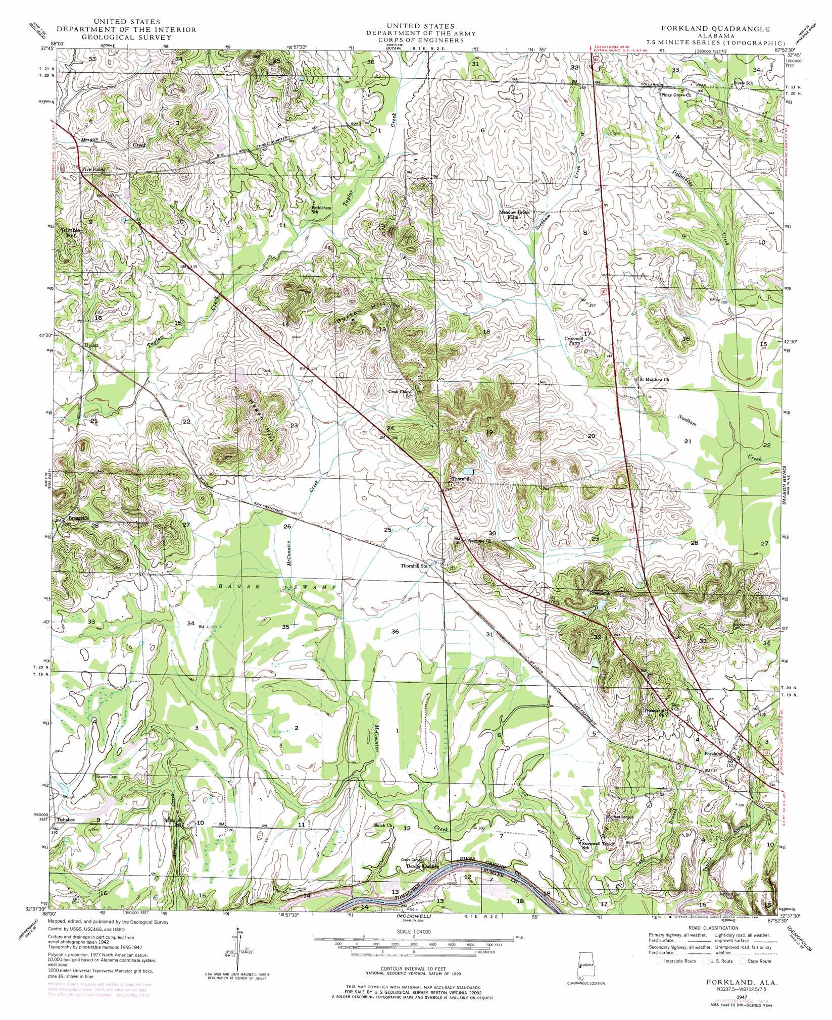
Forkland Topo Map Alabama
To zoom in, hover over the map of Forkland
USGS Topo Quad 32087f8 - 1:24,000 scale
| Topo Map Name: | Forkland |
| USGS Topo Quad ID: | 32087f8 |
| Print Size: | ca. 21 1/4" wide x 27" high |
| Southeast Coordinates: | 32.625° N latitude / 87.875° W longitude |
| Map Center Coordinates: | 32.6875° N latitude / 87.9375° W longitude |
| U.S. State: | AL |
| Filename: | o32087f8.jpg |
| Download Map JPG Image: | Forkland topo map 1:24,000 scale |
| Map Type: | Topographic |
| Topo Series: | 7.5´ |
| Map Scale: | 1:24,000 |
| Source of Map Images: | United States Geological Survey (USGS) |
| Alternate Map Versions: |
Forkland AL 1947, updated 1973 Download PDF Buy paper map Forkland AL 1947, updated 1979 Download PDF Buy paper map Forkland AL 1947, updated 1984 Download PDF Buy paper map Forkland AL 1949 Download PDF Buy paper map Forkland AL 2011 Download PDF Buy paper map Forkland AL 2014 Download PDF Buy paper map |
1:24,000 Topo Quads surrounding Forkland
Warsaw |
West Greene |
Union |
Knoxville |
Moundville West |
Gainesville |
Boligee |
Eutaw |
Warrior Dam |
Sawyerville |
Epes West |
Epes East |
Forkland |
Mason Bend |
Melton |
Livingston |
Brewersville |
Mcdowell |
Demopolis |
Casemore |
Bellamy |
Coatopa |
Jefferson |
Old Spring Hill |
Gallion |
> Back to 32087e1 at 1:100,000 scale
> Back to 32086a1 at 1:250,000 scale
> Back to U.S. Topo Maps home
Forkland topo map: Gazetteer
Forkland: Bars
Durdens Bar elevation 25m 82′Forkland: Crossings
Durdens Ferry (historical) elevation 22m 72′Forkland: Dams
G W Baker Dam elevation 56m 183′Reed Dam elevation 46m 150′
W D Johnston Dams elevation 42m 137′
Forkland: Populated Places
Braggville elevation 74m 242′Five Points elevation 57m 187′
Forkland elevation 46m 150′
Hycutt elevation 37m 121′
Rosemont elevation 75m 246′
Thornhill elevation 69m 226′
Tishabee elevation 43m 141′
Forkland: Post Offices
Burtons Hill Post Office (historical) elevation 68m 223′Forkland Post Office elevation 46m 150′
McConnico Post Office (historical) elevation 33m 108′
Forkland: Reservoirs
Baker Lake elevation 56m 183′Johnstons Lake Number Three elevation 42m 137′
Reed Lake elevation 46m 150′
Forkland: Streams
Acron Creek elevation 22m 72′Cobb Creek elevation 30m 98′
Forkland: Summits
Bullocks Hill elevation 77m 252′Burton Hill elevation 84m 275′
Hagan Hill elevation 79m 259′
Forkland: Swamps
Hagan Swamp elevation 37m 121′Forkland digital topo map on disk
Buy this Forkland topo map showing relief, roads, GPS coordinates and other geographical features, as a high-resolution digital map file on DVD:
Gulf Coast (LA, MS, AL, FL) & Southwestern Georgia
Buy digital topo maps: Gulf Coast (LA, MS, AL, FL) & Southwestern Georgia
 & Southwestern Georgia map DVD")