Warrior Dam Topo Map Alabama
To zoom in, hover over the map of Warrior Dam
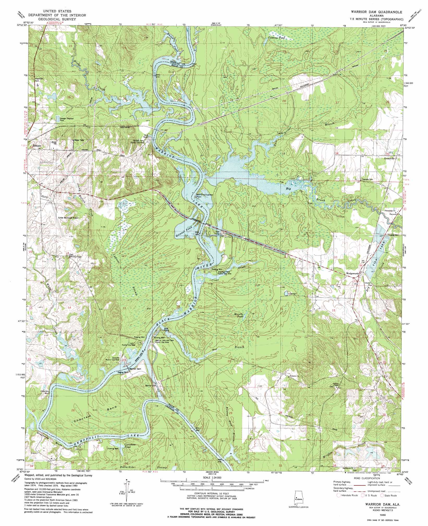
USGS Topo Quad 32087g7 - 1:24,000 scale
| Topo Map Name: | Warrior Dam |
| USGS Topo Quad ID: | 32087g7 |
| Print Size: | ca. 21 1/4" wide x 27" high |
| Southeast Coordinates: | 32.75° N latitude / 87.75° W longitude |
| Map Center Coordinates: | 32.8125° N latitude / 87.8125° W longitude |
| U.S. State: | AL |
| Filename: | o32087g7.jpg |
| Download Map JPG Image: | Warrior Dam topo map 1:24,000 scale |
| Map Type: | Topographic |
| Topo Series: | 7.5´ |
| Map Scale: | 1:24,000 |
| Source of Map Images: | United States Geological Survey (USGS) |
| Alternate Map Versions: |
Warrior Dam AL 1980, updated 1980 Download PDF Buy paper map Warrior Dam AL 2011 Download PDF Buy paper map Warrior Dam AL 2014 Download PDF Buy paper map |
1:24,000 Topo Quads surrounding Warrior Dam
Pleasant Ridge |
Mantua |
Ralph |
Fosters |
Englewood |
West Greene |
Union |
Knoxville |
Moundville West |
Moundville East |
Boligee |
Eutaw |
Warrior Dam |
Sawyerville |
Ingram |
Epes East |
Forkland |
Mason Bend |
Melton |
Greensboro |
Brewersville |
Mcdowell |
Demopolis |
Casemore |
Newbern |
> Back to 32087e1 at 1:100,000 scale
> Back to 32086a1 at 1:250,000 scale
> Back to U.S. Topo Maps home
Warrior Dam topo map: Gazetteer
Warrior Dam: Airports
Eutaw Municipal Airport elevation 48m 157′Warrior Dam: Bars
Big Creek Shoals elevation 30m 98′Big Log Shoals (historical) elevation 29m 95′
Choctaw Bar elevation 27m 88′
Duck Bar elevation 26m 85′
Finches Ferry Bar (historical) elevation 41m 134′
Halls Shoals elevation 26m 85′
Lumbus Bar elevation 31m 101′
Milkhouse Bar elevation 29m 95′
Pickens Bar (historical) elevation 29m 95′
Warrior Dam: Bends
Choctaw Bend elevation 31m 101′Warrior Dam: Bridges
Oscar Underwood Bridge elevation 31m 101′Underwood Bridge elevation 29m 95′
Warrior Dam: Capes
Finches Point elevation 31m 101′Jennings Ferry Point elevation 30m 98′
Jenny Watts Point elevation 27m 88′
Standing Cypress Point elevation 29m 95′
Warrior Dam: Cliffs
Browns Bluff elevation 29m 95′Choctaw Bluff elevation 33m 108′
Meltons Bluff elevation 30m 98′
Samples Bluff elevation 31m 101′
Stave Bluff elevation 31m 101′
Stephens Bluff elevation 31m 101′
Warrior Dam: Crossings
Cridleys Ferry (historical) elevation 32m 104′Finches Ferry (historical) elevation 29m 95′
Jennings Ferry (historical) elevation 30m 98′
Warrior Dam: Dams
Howard Brown Dam elevation 27m 88′Lewis Lawson Dam Number 1 elevation 54m 177′
Lewis Lawson Dam Number 2 elevation 47m 154′
Lock Seven elevation 29m 95′
Warrior Lock and Dam elevation 30m 98′
Warrior Dam: Lakes
Coleman Pond elevation 30m 98′Crenshaw Pond elevation 31m 101′
Grinnel Pond elevation 29m 95′
Manette Pond elevation 30m 98′
Warrior Lake elevation 29m 95′
Warrior Dam: Parks
Damsite Public Use Area elevation 29m 95′Finches Ferry Public Use Area elevation 56m 183′
Jennings Ferry Public Use Area elevation 30m 98′
Lock Seven Public Use Area elevation 31m 101′
Warrior Lock and Dam Public Use Area elevation 32m 104′
Warrior Dam: Populated Places
Darrah elevation 34m 111′Evansville elevation 40m 131′
Gosa elevation 40m 131′
McClure elevation 41m 134′
Wedgeworth elevation 43m 141′
Warrior Dam: Reservoirs
Howard Brown Lake elevation 27m 88′Lawson Lakes elevation 54m 177′
Lawson Lakes elevation 47m 154′
Warrior Lake elevation 36m 118′
Warrior Dam: Streams
Big Brush Creek elevation 30m 98′Dry Creek elevation 33m 108′
Jenny Watson Creek elevation 32m 104′
Jordan Branch elevation 34m 111′
Minter Creek elevation 29m 95′
Pole Bridge Branch elevation 29m 95′
Presley Ford Branch elevation 22m 72′
Slack Creek elevation 22m 72′
Stephens Creek elevation 27m 88′
White Creek elevation 29m 95′
Whites Creek elevation 29m 95′
Warrior Dam: Swamps
Cypress Swamp elevation 30m 98′Dollarhide Swamp elevation 29m 95′
Warrior Dam digital topo map on disk
Buy this Warrior Dam topo map showing relief, roads, GPS coordinates and other geographical features, as a high-resolution digital map file on DVD:
Gulf Coast (LA, MS, AL, FL) & Southwestern Georgia
Buy digital topo maps: Gulf Coast (LA, MS, AL, FL) & Southwestern Georgia
 & Southwestern Georgia map DVD")