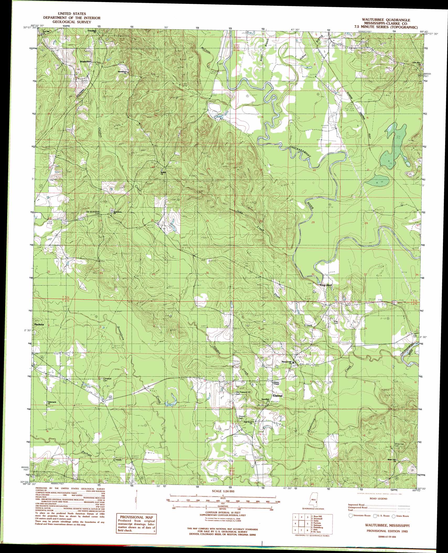
Wautubbee Topo Map Mississippi
To zoom in, hover over the map of Wautubbee
USGS Topo Quad 32088a7 - 1:24,000 scale
| Topo Map Name: | Wautubbee |
| USGS Topo Quad ID: | 32088a7 |
| Print Size: | ca. 21 1/4" wide x 27" high |
| Southeast Coordinates: | 32° N latitude / 88.75° W longitude |
| Map Center Coordinates: | 32.0625° N latitude / 88.8125° W longitude |
| U.S. State: | MS |
| Filename: | o32088a7.jpg |
| Download Map JPG Image: | Wautubbee topo map 1:24,000 scale |
| Map Type: | Topographic |
| Topo Series: | 7.5´ |
| Map Scale: | 1:24,000 |
| Source of Map Images: | United States Geological Survey (USGS) |
| Alternate Map Versions: |
Wautubbee MS 1983, updated 1983 Download PDF Buy paper map Wautubbee MS 2012 Download PDF Buy paper map Wautubbee MS 2015 Download PDF Buy paper map |
1:24,000 Topo Quads surrounding Wautubbee
Hickory |
Chunky |
Meehan |
Meridian South |
Vimville |
Hero |
Rose Hill |
Stonewall |
Sable |
Snell |
Paulding |
Pachuta |
Wautubbee |
Quittman |
Sykes |
Waldrup |
Heidelberg |
Hale |
De Soto |
Carmichael |
Sandersville |
Heidelberg Sw |
Eucutta |
Shubuta |
Matherville |
> Back to 32088a1 at 1:100,000 scale
> Back to 32088a1 at 1:250,000 scale
> Back to U.S. Topo Maps home
Wautubbee topo map: Gazetteer
Wautubbee: Bridges
McCloud Bridge elevation 67m 219′Scarbrough Bridge (historical) elevation 67m 219′
Wautubbee: Cliffs
King Bluff elevation 80m 262′Wautubbee: Dams
Kidd Lake Dam elevation 121m 396′Wautubbee: Oilfields
Pachuta Oil Field elevation 73m 239′Wautubbee: Populated Places
Choctaw (historical) elevation 71m 232′Elwood elevation 77m 252′
Wautubbee elevation 116m 380′
Wautubbee: Streams
Alligator Branch elevation 66m 216′Bostic Branch elevation 65m 213′
Gordon Creek elevation 64m 209′
Green Branch elevation 64m 209′
Johns Branch elevation 68m 223′
McCants Creek elevation 70m 229′
Oaky Creek elevation 65m 213′
Pachuta Creek elevation 70m 229′
Shots Creek elevation 63m 206′
Souenlovie Creek elevation 57m 187′
Wautubbee digital topo map on disk
Buy this Wautubbee topo map showing relief, roads, GPS coordinates and other geographical features, as a high-resolution digital map file on DVD:
Gulf Coast (LA, MS, AL, FL) & Southwestern Georgia
Buy digital topo maps: Gulf Coast (LA, MS, AL, FL) & Southwestern Georgia
 & Southwestern Georgia map DVD")