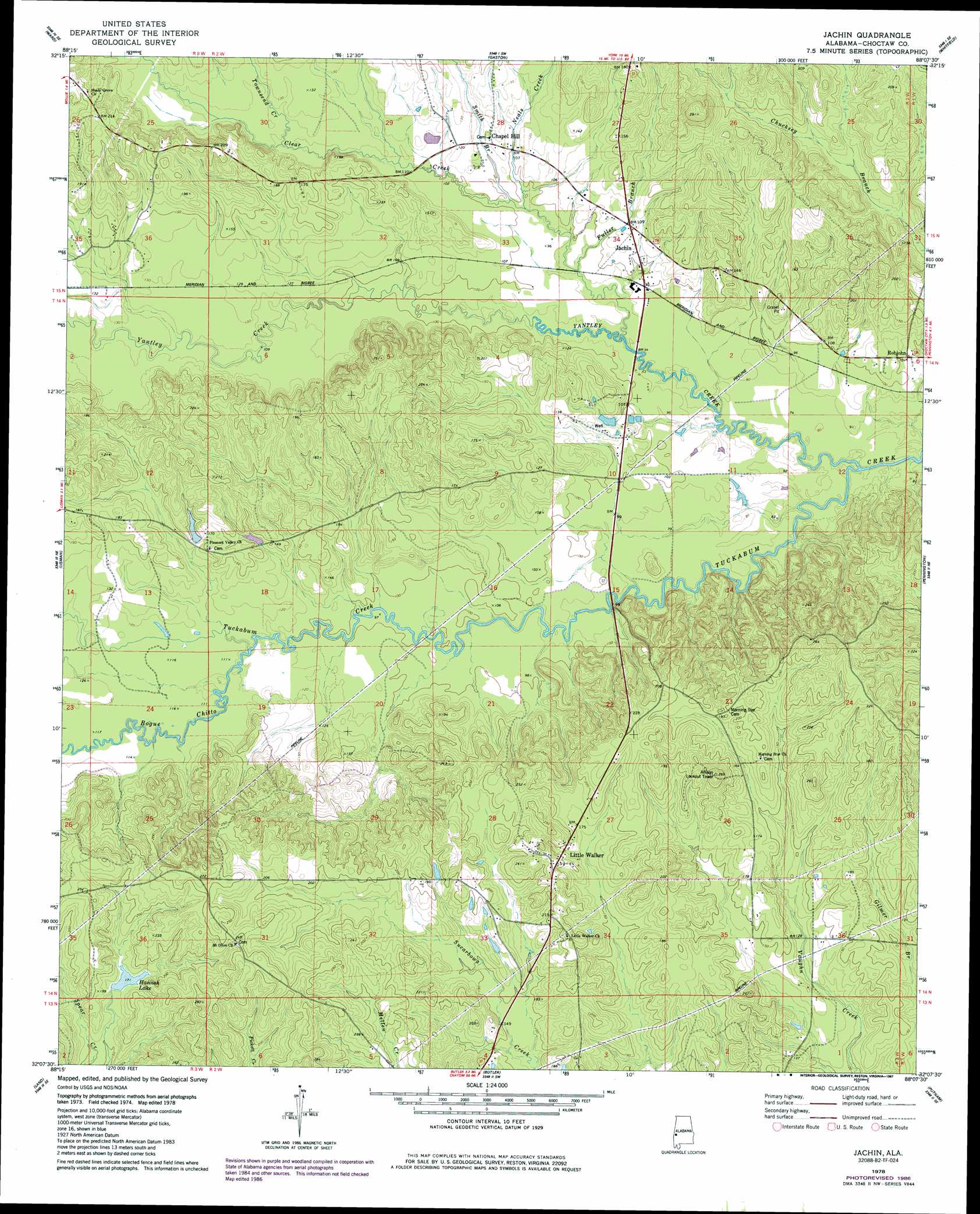
Jachin Topo Map Alabama
To zoom in, hover over the map of Jachin
USGS Topo Quad 32088b2 - 1:24,000 scale
| Topo Map Name: | Jachin |
| USGS Topo Quad ID: | 32088b2 |
| Print Size: | ca. 21 1/4" wide x 27" high |
| Southeast Coordinates: | 32.125° N latitude / 88.125° W longitude |
| Map Center Coordinates: | 32.1875° N latitude / 88.1875° W longitude |
| U.S. State: | AL |
| Filename: | o32088b2.jpg |
| Download Map JPG Image: | Jachin topo map 1:24,000 scale |
| Map Type: | Topographic |
| Topo Series: | 7.5´ |
| Map Scale: | 1:24,000 |
| Source of Map Images: | United States Geological Survey (USGS) |
| Alternate Map Versions: |
Jachin AL 1978, updated 1979 Download PDF Buy paper map Jachin AL 1978, updated 1987 Download PDF Buy paper map Jachin AL 2011 Download PDF Buy paper map Jachin AL 2014 Download PDF Buy paper map |
1:24,000 Topo Quads surrounding Jachin
Kewanee |
York |
Bellamy |
Coatopa |
Jefferson |
Whynot |
Ward |
Gaston |
Whitfield |
Myrtlewood North |
Yantley |
Lisman |
Jachin |
Pennington |
Myrtlewood South |
Hinton |
Land |
Butler |
Putnam |
Nanafalia |
Melvin |
Toxey |
Ararat |
Woods Bluff |
Morvin |
> Back to 32088a1 at 1:100,000 scale
> Back to 32088a1 at 1:250,000 scale
> Back to U.S. Topo Maps home
Jachin topo map: Gazetteer
Jachin: Dams
D T Hannah Lake Dam elevation 52m 170′Donald Hesselman Lake Dam elevation 43m 141′
Jachin: Populated Places
Chapel Hill elevation 35m 114′Jachin elevation 33m 108′
Little Walker elevation 68m 223′
Robjohn elevation 30m 98′
Jachin: Reservoirs
Donald Hesselman Lake elevation 43m 141′Hannah Lake elevation 52m 170′
Jachin: Streams
Bogue Chitto elevation 34m 111′Bogue Chitto elevation 34m 111′
Clear Creek elevation 24m 78′
Fuller Branch elevation 27m 88′
Neals Creek elevation 30m 98′
Smith Branch elevation 30m 98′
Tanyard Creek elevation 31m 101′
Townsend Branch elevation 33m 108′
Townsend Creek elevation 33m 108′
Yantley Creek elevation 21m 68′
Jachin digital topo map on disk
Buy this Jachin topo map showing relief, roads, GPS coordinates and other geographical features, as a high-resolution digital map file on DVD:
Gulf Coast (LA, MS, AL, FL) & Southwestern Georgia
Buy digital topo maps: Gulf Coast (LA, MS, AL, FL) & Southwestern Georgia
 & Southwestern Georgia map DVD")