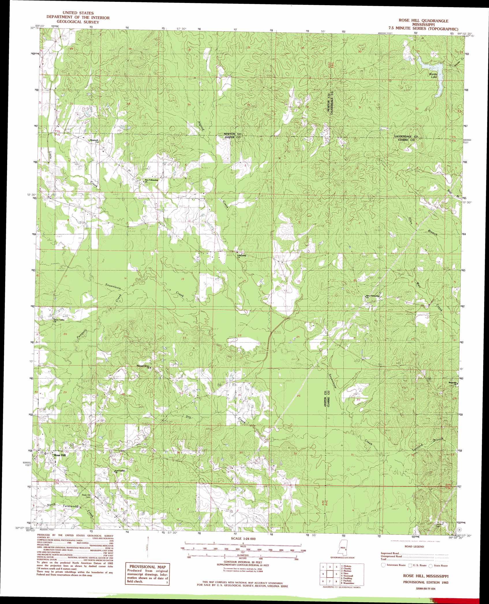
Rose Hill Topo Map Mississippi
To zoom in, hover over the map of Rose Hill
USGS Topo Quad 32088b8 - 1:24,000 scale
| Topo Map Name: | Rose Hill |
| USGS Topo Quad ID: | 32088b8 |
| Print Size: | ca. 21 1/4" wide x 27" high |
| Southeast Coordinates: | 32.125° N latitude / 88.875° W longitude |
| Map Center Coordinates: | 32.1875° N latitude / 88.9375° W longitude |
| U.S. State: | MS |
| Filename: | o32088b8.jpg |
| Download Map JPG Image: | Rose Hill topo map 1:24,000 scale |
| Map Type: | Topographic |
| Topo Series: | 7.5´ |
| Map Scale: | 1:24,000 |
| Source of Map Images: | United States Geological Survey (USGS) |
| Alternate Map Versions: |
Rose Hill MS 1983, updated 1983 Download PDF Buy paper map Rose Hill MS 2012 Download PDF Buy paper map Rose Hill MS 2015 Download PDF Buy paper map |
1:24,000 Topo Quads surrounding Rose Hill
Decatur Nw |
Decatur |
Duffee |
Collinsville |
Meridian North |
Newton |
Hickory |
Chunky |
Meehan |
Meridian South |
Montrose North |
Hero |
Rose Hill |
Stonewall |
Sable |
Montrose South |
Paulding |
Pachuta |
Wautubbee |
Quittman |
Lake Como |
Waldrup |
Heidelberg |
Hale |
De Soto |
> Back to 32088a1 at 1:100,000 scale
> Back to 32088a1 at 1:250,000 scale
> Back to U.S. Topo Maps home
Rose Hill topo map: Gazetteer
Rose Hill: Dams
McCormick Lake Dam elevation 103m 337′Wanita Lake Dam elevation 92m 301′
Rose Hill: Populated Places
Fellowship elevation 95m 311′New Fellowship elevation 104m 341′
Rose Hill elevation 116m 380′
Rose Hill: Post Offices
Rose Hill Post Office elevation 116m 380′Rose Hill: Reservoirs
Wanita Lake elevation 85m 278′Wanitka Lake elevation 113m 370′
Rose Hill: Streams
Algood Creek elevation 90m 295′Dry Creek elevation 85m 278′
Johnson Creek elevation 103m 337′
Little Creek elevation 92m 301′
Penantly Creek elevation 91m 298′
Tanyard Branch elevation 82m 269′
Rose Hill digital topo map on disk
Buy this Rose Hill topo map showing relief, roads, GPS coordinates and other geographical features, as a high-resolution digital map file on DVD:
Gulf Coast (LA, MS, AL, FL) & Southwestern Georgia
Buy digital topo maps: Gulf Coast (LA, MS, AL, FL) & Southwestern Georgia
 & Southwestern Georgia map DVD")