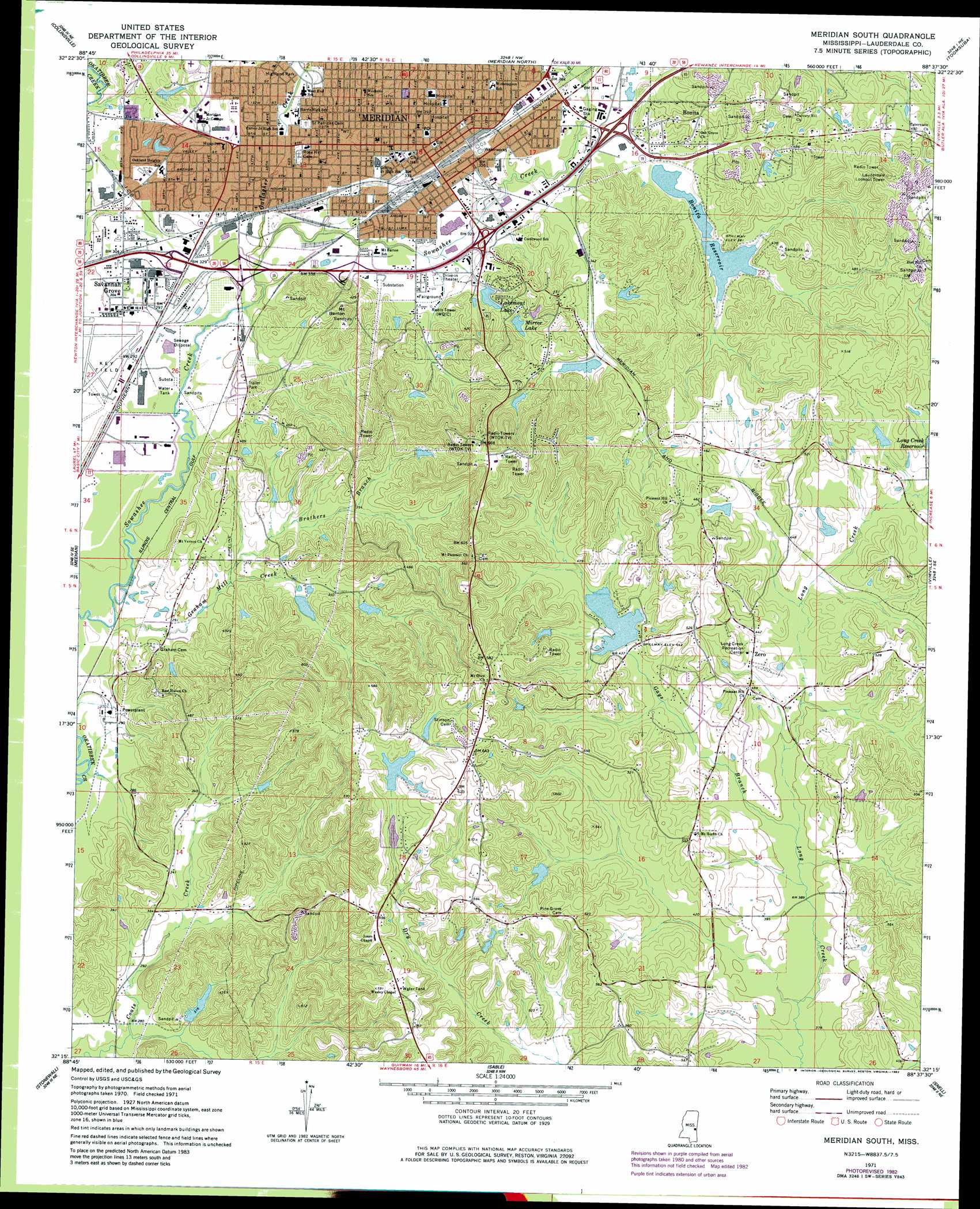
Meridian South Topo Map Mississippi
To zoom in, hover over the map of Meridian South
USGS Topo Quad 32088c6 - 1:24,000 scale
| Topo Map Name: | Meridian South |
| USGS Topo Quad ID: | 32088c6 |
| Print Size: | ca. 21 1/4" wide x 27" high |
| Southeast Coordinates: | 32.25° N latitude / 88.625° W longitude |
| Map Center Coordinates: | 32.3125° N latitude / 88.6875° W longitude |
| U.S. State: | MS |
| Filename: | o32088c6.jpg |
| Download Map JPG Image: | Meridian South topo map 1:24,000 scale |
| Map Type: | Topographic |
| Topo Series: | 7.5´ |
| Map Scale: | 1:24,000 |
| Source of Map Images: | United States Geological Survey (USGS) |
| Alternate Map Versions: |
Meridian South MS 1971, updated 1973 Download PDF Buy paper map Meridian South MS 1971, updated 1982 Download PDF Buy paper map Meridian South MS 2012 Download PDF Buy paper map Meridian South MS 2015 Download PDF Buy paper map |
1:24,000 Topo Quads surrounding Meridian South
Post |
Center Hill |
Daleville |
Lauderdale |
Tamola |
Duffee |
Collinsville |
Meridian North |
Toomsuba |
Kewanee |
Chunky |
Meehan |
Meridian South |
Vimville |
Whynot |
Rose Hill |
Stonewall |
Sable |
Snell |
Yantley |
Pachuta |
Wautubbee |
Quittman |
Sykes |
Hinton |
> Back to 32088a1 at 1:100,000 scale
> Back to 32088a1 at 1:250,000 scale
> Back to U.S. Topo Maps home
Meridian South topo map: Gazetteer
Meridian South: Airports
Andersons Hospital Helipad elevation 111m 364′Meridian South: Crossings
Interchange 150 elevation 97m 318′Interchange 151 elevation 95m 311′
Interchange 152 elevation 93m 305′
Interchange 153 elevation 98m 321′
Interchange 154 elevation 104m 341′
Meridian South: Dams
A P Carney Senior Lake Dam elevation 134m 439′B Hardy Pond Dam elevation 144m 472′
Bonita Reservoir Number 1 Dam elevation 104m 341′
Bonita Reservoir Number 2 Dam elevation 107m 351′
Bonita Reservoir Number 3 Dam elevation 110m 360′
C D Shields Pond Dam elevation 154m 505′
Covington Lake Dam elevation 124m 406′
Cresant Lake Dam elevation 138m 452′
Faulkner Lake Dam elevation 117m 383′
Gene Nunnery Dam elevation 92m 301′
Grady Smith Pond Dam elevation 147m 482′
Graham Lake Dam elevation 158m 518′
I Taylor Catfish Ponds Dam elevation 165m 541′
James Gilbert Pond Dam elevation 121m 396′
James Gilbert Pond Dam elevation 147m 482′
L Taylor Lake Dam elevation 134m 439′
Lakemont Lake Dam elevation 98m 321′
Leonard Taylor Pond Dam elevation 170m 557′
Mirrow Lake Dam elevation 113m 370′
Oakland Heights Lake Dam elevation 99m 324′
R E Scruggs Catfish Ponds Dam elevation 128m 419′
Roland Kimbrell Lake Dam elevation 141m 462′
Shrine Club Lake Dam elevation 135m 442′
State Hospital Lake Dam elevation 104m 341′
Meridian South: Lakes
Lakemont Lake elevation 107m 351′Mirror Lake elevation 113m 370′
Meridian South: Parks
Highland Park elevation 95m 311′Meridian South: Populated Places
Bonita elevation 107m 351′Meridian elevation 105m 344′
Pleasant Hill elevation 140m 459′
Savannah Grove elevation 92m 301′
Stinson elevation 184m 603′
Wolf Springs elevation 178m 583′
Zero elevation 137m 449′
Meridian South: Post Offices
Meridian Post Office elevation 107m 351′Meridian South: Reservoirs
Bonita Reservoir elevation 102m 334′Webb Lake elevation 116m 380′
Meridian South: Springs
Drinkwater Spring elevation 138m 452′Meridian South: Streams
Brothers Branch elevation 90m 295′Gallagher Creek elevation 93m 305′
Gays Branch elevation 118m 387′
Graham Mill Creek elevation 82m 269′
Robbins Branch elevation 101m 331′
Meridian South: Summits
Mount Barton elevation 147m 482′Meridian South digital topo map on disk
Buy this Meridian South topo map showing relief, roads, GPS coordinates and other geographical features, as a high-resolution digital map file on DVD:
Gulf Coast (LA, MS, AL, FL) & Southwestern Georgia
Buy digital topo maps: Gulf Coast (LA, MS, AL, FL) & Southwestern Georgia
 & Southwestern Georgia map DVD")