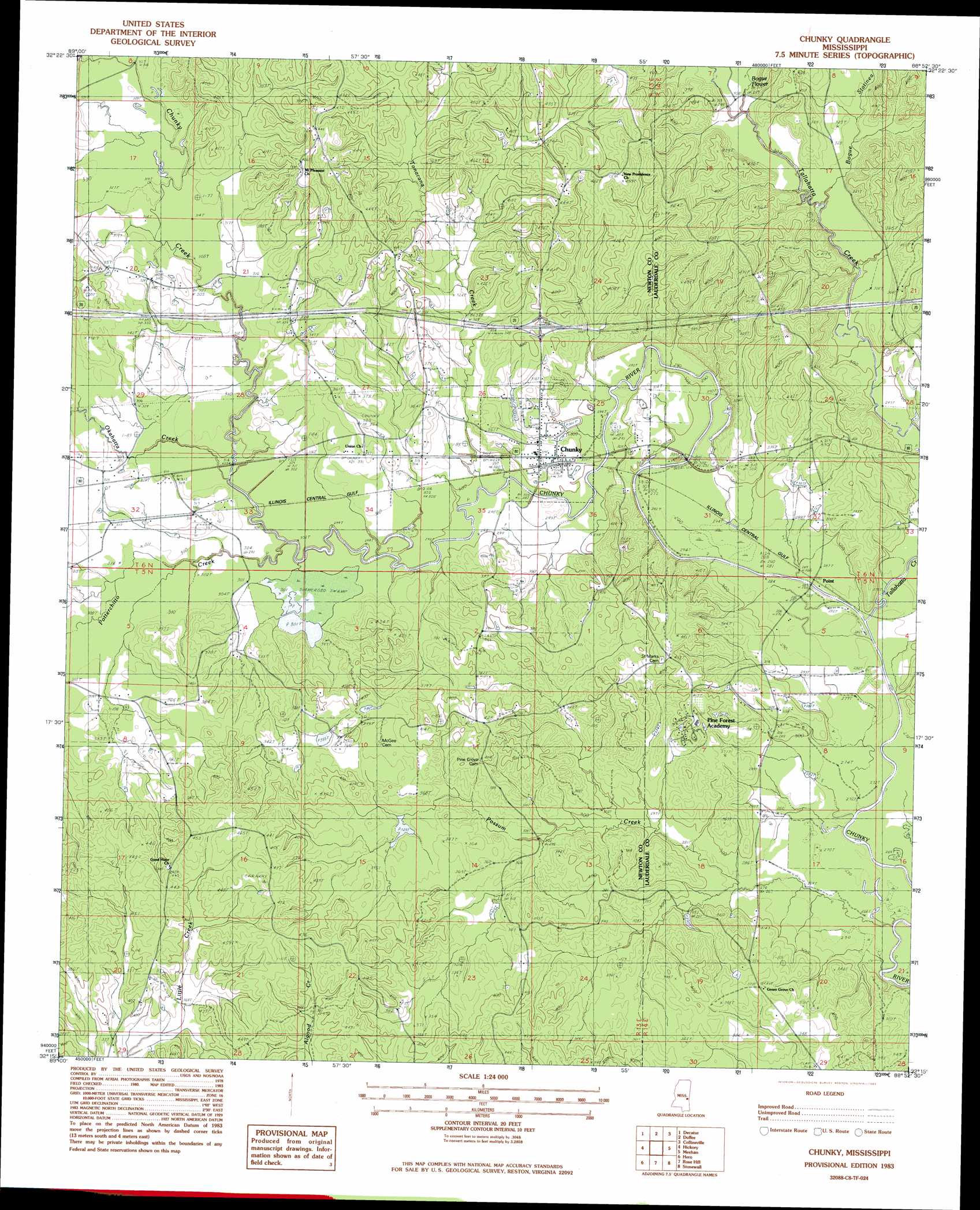
Chunky Topo Map Mississippi
To zoom in, hover over the map of Chunky
USGS Topo Quad 32088c8 - 1:24,000 scale
| Topo Map Name: | Chunky |
| USGS Topo Quad ID: | 32088c8 |
| Print Size: | ca. 21 1/4" wide x 27" high |
| Southeast Coordinates: | 32.25° N latitude / 88.875° W longitude |
| Map Center Coordinates: | 32.3125° N latitude / 88.9375° W longitude |
| U.S. State: | MS |
| Filename: | o32088c8.jpg |
| Download Map JPG Image: | Chunky topo map 1:24,000 scale |
| Map Type: | Topographic |
| Topo Series: | 7.5´ |
| Map Scale: | 1:24,000 |
| Source of Map Images: | United States Geological Survey (USGS) |
| Alternate Map Versions: |
Chunky MS 1983, updated 1983 Download PDF Buy paper map Chunky MS 1983, updated 1990 Download PDF Buy paper map Chunky MS 2012 Download PDF Buy paper map Chunky MS 2015 Download PDF Buy paper map |
1:24,000 Topo Quads surrounding Chunky
Union West |
Union East |
Post |
Center Hill |
Daleville |
Decatur Nw |
Decatur |
Duffee |
Collinsville |
Meridian North |
Newton |
Hickory |
Chunky |
Meehan |
Meridian South |
Montrose North |
Hero |
Rose Hill |
Stonewall |
Sable |
Montrose South |
Paulding |
Pachuta |
Wautubbee |
Quittman |
> Back to 32088a1 at 1:100,000 scale
> Back to 32088a1 at 1:250,000 scale
> Back to U.S. Topo Maps home
Chunky topo map: Gazetteer
Chunky: Crossings
Interchange 121 elevation 122m 400′Chunky: Dams
Germeny Lake Dam elevation 103m 337′Mrs Graham Lake Dam elevation 91m 298′
Peavy Pond Dam elevation 92m 301′
Pine Forest Academy Pond Dam elevation 106m 347′
Chunky: Populated Places
Chunky elevation 97m 318′New Providence elevation 130m 426′
Chunky: Streams
Blue Branch elevation 90m 295′Bogue Flower elevation 90m 295′
Bogue Statinea elevation 91m 298′
Chunky Creek elevation 92m 301′
Okahatta Creek elevation 91m 298′
Possum Creek elevation 80m 262′
Potterchitto Creek elevation 92m 301′
Tallahatta Creek elevation 82m 269′
Tonacana Creek elevation 89m 291′
Chunky digital topo map on disk
Buy this Chunky topo map showing relief, roads, GPS coordinates and other geographical features, as a high-resolution digital map file on DVD:
Gulf Coast (LA, MS, AL, FL) & Southwestern Georgia
Buy digital topo maps: Gulf Coast (LA, MS, AL, FL) & Southwestern Georgia
 & Southwestern Georgia map DVD")