Kewanee Topo Map Mississippi
To zoom in, hover over the map of Kewanee
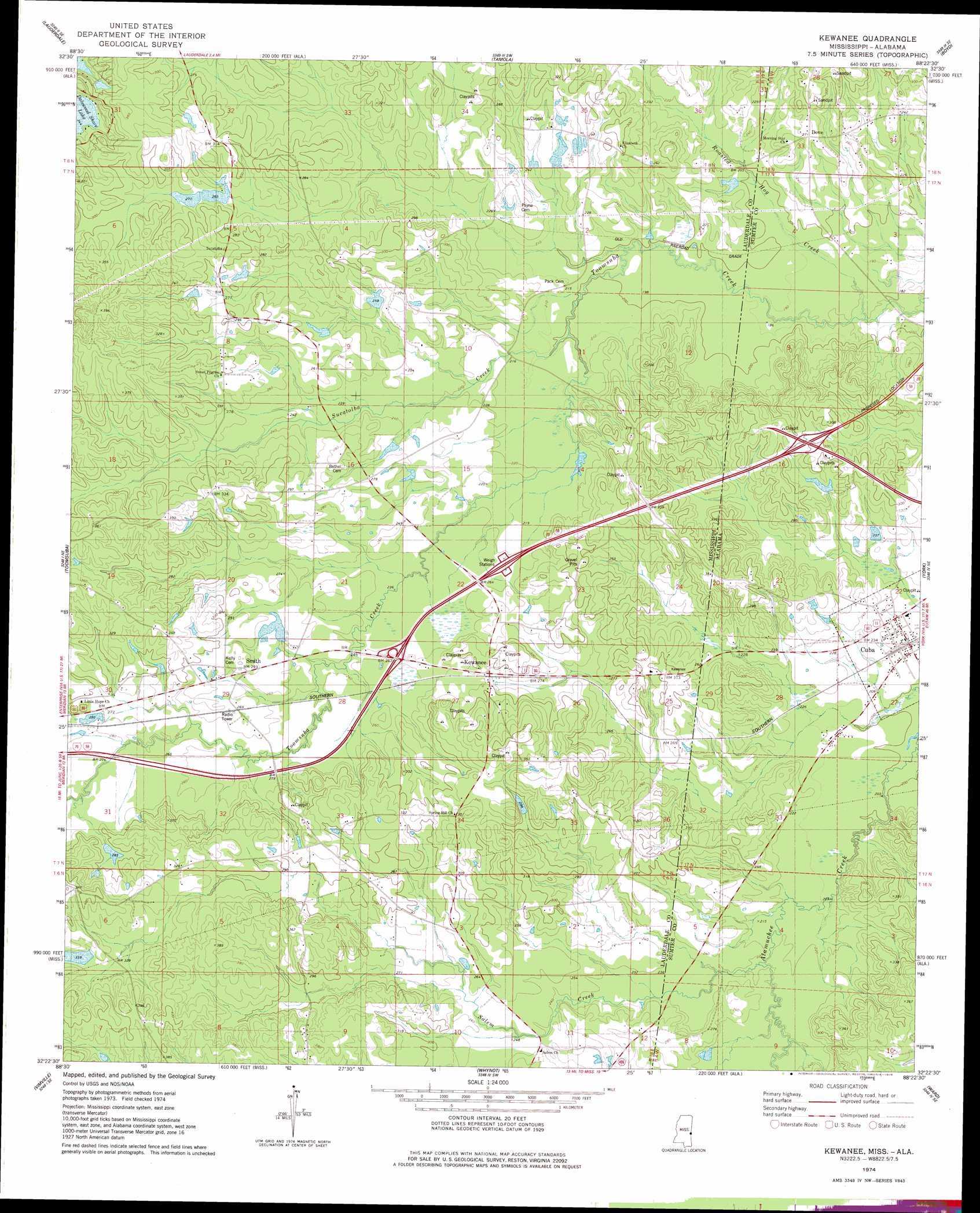
USGS Topo Quad 32088d4 - 1:24,000 scale
| Topo Map Name: | Kewanee |
| USGS Topo Quad ID: | 32088d4 |
| Print Size: | ca. 21 1/4" wide x 27" high |
| Southeast Coordinates: | 32.375° N latitude / 88.375° W longitude |
| Map Center Coordinates: | 32.4375° N latitude / 88.4375° W longitude |
| U.S. States: | MS, AL |
| Filename: | o32088d4.jpg |
| Download Map JPG Image: | Kewanee topo map 1:24,000 scale |
| Map Type: | Topographic |
| Topo Series: | 7.5´ |
| Map Scale: | 1:24,000 |
| Source of Map Images: | United States Geological Survey (USGS) |
| Alternate Map Versions: |
Kewanee MS 1974, updated 1978 Download PDF Buy paper map Kewanee MS 2012 Download PDF Buy paper map Kewanee MS 2015 Download PDF Buy paper map |
1:24,000 Topo Quads surrounding Kewanee
Lauderdale Nw |
Oak Grove |
Porterville |
Emelle |
Epes West |
Daleville |
Lauderdale |
Tamola |
Boyd |
Livingston |
Meridian North |
Toomsuba |
Kewanee |
York |
Bellamy |
Meridian South |
Vimville |
Whynot |
Ward |
Gaston |
Sable |
Snell |
Yantley |
Lisman |
Jachin |
> Back to 32088a1 at 1:100,000 scale
> Back to 32088a1 at 1:250,000 scale
> Back to U.S. Topo Maps home
Kewanee topo map: Gazetteer
Kewanee: Crossings
Interchange 1 elevation 91m 298′Interchange 169 elevation 75m 246′
Kewanee: Dams
Buddy Webb Pond Dam elevation 82m 269′Dogwood Lake Dam elevation 56m 183′
Ed Snow Lake Dam elevation 110m 360′
H A Pickett Lake Dam elevation 80m 262′
Johnny Allen Pond Dam elevation 72m 236′
K B Mitchell Pond Dam elevation 62m 203′
Mrs Jack Morman Pond Dam elevation 85m 278′
Mrs R E Payne Pond Dam elevation 74m 242′
Pickfords Lake Dam elevation 81m 265′
R B Lynch Catfish Ponds Dam elevation 73m 239′
W T Simmons Pond Dam elevation 80m 262′
Kewanee: Populated Places
Cuba elevation 66m 216′Dove elevation 84m 275′
Kewanee elevation 86m 282′
Smith elevation 86m 282′
Kewanee: Post Offices
Cuba Post Office elevation 67m 219′Kewanee: Reservoirs
Dalewood Shore Lake elevation 70m 229′Kewanee: Streams
Roasted Hog Creek elevation 55m 180′Salem Creek elevation 67m 219′
Salem Creek elevation 67m 219′
Sucatolba Creek elevation 60m 196′
Kewanee digital topo map on disk
Buy this Kewanee topo map showing relief, roads, GPS coordinates and other geographical features, as a high-resolution digital map file on DVD:
Gulf Coast (LA, MS, AL, FL) & Southwestern Georgia
Buy digital topo maps: Gulf Coast (LA, MS, AL, FL) & Southwestern Georgia
 & Southwestern Georgia map DVD")