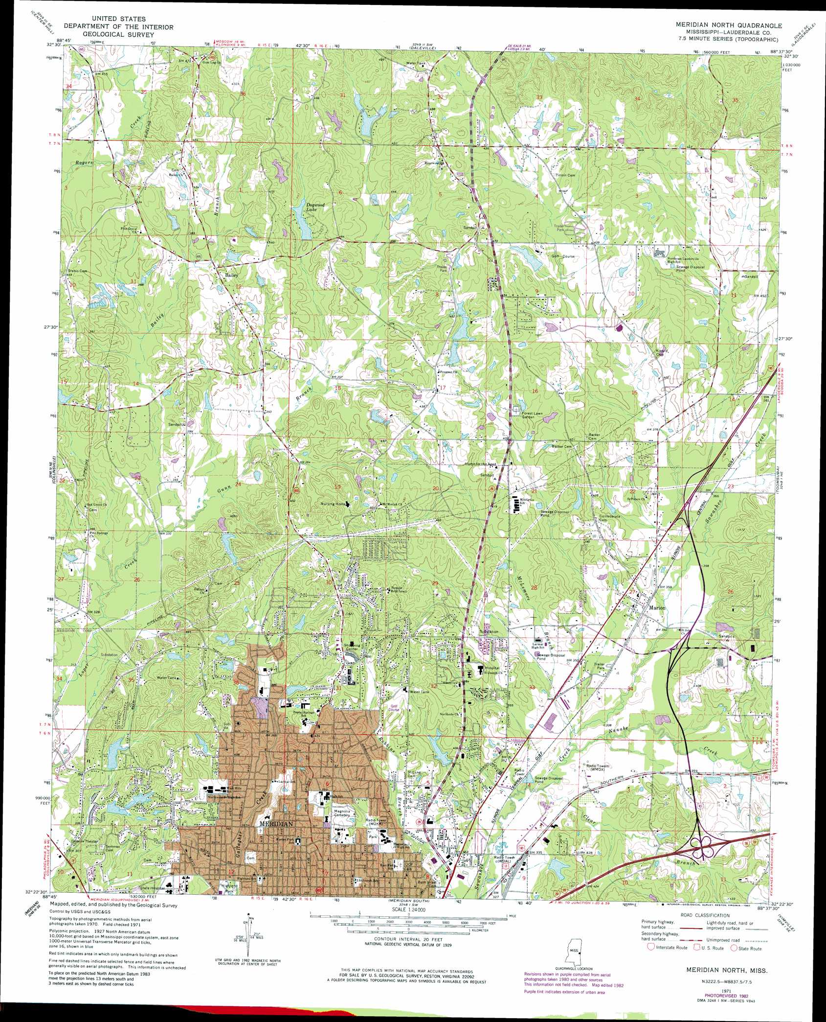
Meridian North Topo Map Mississippi
To zoom in, hover over the map of Meridian North
USGS Topo Quad 32088d6 - 1:24,000 scale
| Topo Map Name: | Meridian North |
| USGS Topo Quad ID: | 32088d6 |
| Print Size: | ca. 21 1/4" wide x 27" high |
| Southeast Coordinates: | 32.375° N latitude / 88.625° W longitude |
| Map Center Coordinates: | 32.4375° N latitude / 88.6875° W longitude |
| U.S. State: | MS |
| Filename: | o32088d6.jpg |
| Download Map JPG Image: | Meridian North topo map 1:24,000 scale |
| Map Type: | Topographic |
| Topo Series: | 7.5´ |
| Map Scale: | 1:24,000 |
| Source of Map Images: | United States Geological Survey (USGS) |
| Alternate Map Versions: |
Meridian North MS 1971, updated 1973 Download PDF Buy paper map Meridian North MS 1971, updated 1982 Download PDF Buy paper map Meridian North MS 2012 Download PDF Buy paper map Meridian North MS 2015 Download PDF Buy paper map |
1:24,000 Topo Quads surrounding Meridian North
House |
Moscow |
Lauderdale Nw |
Oak Grove |
Porterville |
Post |
Center Hill |
Daleville |
Lauderdale |
Tamola |
Duffee |
Collinsville |
Meridian North |
Toomsuba |
Kewanee |
Chunky |
Meehan |
Meridian South |
Vimville |
Whynot |
Rose Hill |
Stonewall |
Sable |
Snell |
Yantley |
> Back to 32088a1 at 1:100,000 scale
> Back to 32088a1 at 1:250,000 scale
> Back to U.S. Topo Maps home
Meridian North topo map: Gazetteer
Meridian North: Crossings
Interchange 157 elevation 131m 429′Meridian North: Dams
Albert Jones Pond Dam elevation 132m 433′Bounds Lake Dam elevation 103m 337′
Briarwood Country Club Dam elevation 142m 465′
Brookshire Lake Dam elevation 139m 456′
C W Downer Pond Dam elevation 126m 413′
Dan Clayton Pond Dam elevation 110m 360′
Dan Clayton Pond Dam elevation 128m 419′
Doctor Mathews Pond Dam elevation 122m 400′
E T Newell Pond Dam elevation 128m 419′
E V Harrington Pond Dam elevation 134m 439′
Ford Covington Catfish Pond Dam elevation 122m 400′
G M Jackon Pond Dam elevation 122m 400′
Gray Cobb Lake Dam elevation 120m 393′
H Sanders Lake Dam elevation 127m 416′
Hasson Pond Dam elevation 123m 403′
Jimmy Scott Lake Dam elevation 122m 400′
Joe Covington Pond Dam elevation 113m 370′
John Egger Pond Dam elevation 129m 423′
L L Major Lake Dam elevation 135m 442′
Lake Druid Dam elevation 110m 360′
Lakewood Lake Dam elevation 103m 337′
Lucille Bunton Pond Dam elevation 123m 403′
Massey Pond Dam elevation 129m 423′
Memorial Park Cemetery Pond Dam elevation 131m 429′
Murry Rogers Catfish Operation Dam elevation 124m 406′
R C Malone Pond Dam elevation 120m 393′
Ray Trawick Lake Dam elevation 140m 459′
Simmons Brothers Pond Dam elevation 117m 383′
Simmons Pond elevation 134m 439′
Town Creek Structure 15b Dam elevation 115m 377′
W Bounds Pond Dam elevation 119m 390′
W E Harbor Pond Dam elevation 141m 462′
William Anderson Pond Dam elevation 125m 410′
Willow Lake Dam elevation 132m 433′
Willow Lakes Dam elevation 122m 400′
Meridian North: Parks
Phil Harden Park elevation 135m 442′Meridian North: Populated Places
Bailey elevation 119m 390′Complete elevation 124m 406′
Houston elevation 135m 442′
Marion elevation 110m 360′
Poplar Springs elevation 140m 459′
Meridian North: Reservoirs
Dogwood Lake elevation 122m 400′Meridian North: Streams
Bailey Branch elevation 97m 318′Clear Branch elevation 98m 321′
Gunn Branch elevation 98m 321′
McLemore Branch elevation 100m 328′
Nanabe Creek elevation 99m 324′
Meridian North digital topo map on disk
Buy this Meridian North topo map showing relief, roads, GPS coordinates and other geographical features, as a high-resolution digital map file on DVD:
Gulf Coast (LA, MS, AL, FL) & Southwestern Georgia
Buy digital topo maps: Gulf Coast (LA, MS, AL, FL) & Southwestern Georgia
 & Southwestern Georgia map DVD")