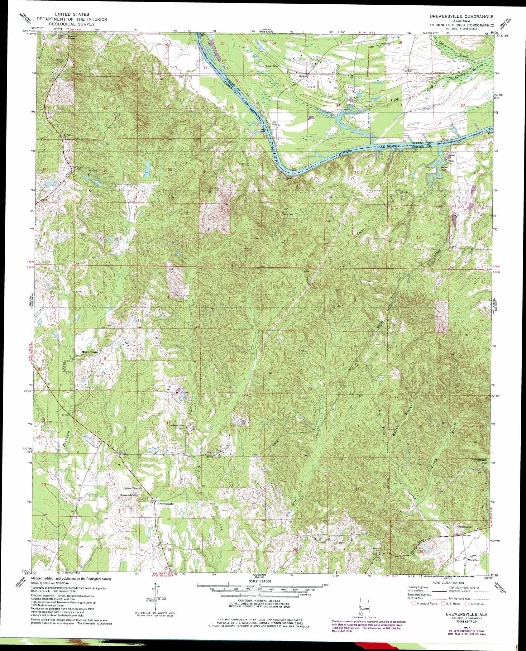
Brewersville Topo Map Alabama
To zoom in, hover over the map of Brewersville
USGS Topo Quad 32088e1 - 1:24,000 scale
| Topo Map Name: | Brewersville |
| USGS Topo Quad ID: | 32088e1 |
| Print Size: | ca. 21 1/4" wide x 27" high |
| Southeast Coordinates: | 32.5° N latitude / 88° W longitude |
| Map Center Coordinates: | 32.5625° N latitude / 88.0625° W longitude |
| U.S. State: | AL |
| Filename: | o32088e1.jpg |
| Download Map JPG Image: | Brewersville topo map 1:24,000 scale |
| Map Type: | Topographic |
| Topo Series: | 7.5´ |
| Map Scale: | 1:24,000 |
| Source of Map Images: | United States Geological Survey (USGS) |
| Alternate Map Versions: |
Brewersville AL 1974, updated 1978 Download PDF Buy paper map Brewersville AL 1974, updated 1986 Download PDF Buy paper map Brewersville AL 2011 Download PDF Buy paper map Brewersville AL 2014 Download PDF Buy paper map |
1:24,000 Topo Quads surrounding Brewersville
Geiger |
Gainesville |
Boligee |
Eutaw |
Warrior Dam |
Emelle |
Epes West |
Epes East |
Forkland |
Mason Bend |
Boyd |
Livingston |
Brewersville |
Mcdowell |
Demopolis |
York |
Bellamy |
Coatopa |
Jefferson |
Old Spring Hill |
Ward |
Gaston |
Whitfield |
Myrtlewood North |
Linden |
> Back to 32088e1 at 1:100,000 scale
> Back to 32088a1 at 1:250,000 scale
> Back to U.S. Topo Maps home
Brewersville topo map: Gazetteer
Brewersville: Bars
Bluff Port Bar elevation 22m 72′Cold Springs Bar elevation 24m 78′
Brewersville: Cliffs
Buzzard Roost Bluff elevation 60m 196′Brewersville: Crossings
Bluff Port Ferry (historical) elevation 24m 78′Brewersville: Dams
Katherine Allison Dam elevation 47m 154′Brewersville: Guts
Caney Slough elevation 22m 72′Brewersville: Populated Places
Bluffport elevation 87m 285′Brewersville elevation 55m 180′
Dug Hill elevation 73m 239′
Moore Town elevation 62m 203′
Old Bluffport elevation 60m 196′
Woodford elevation 29m 95′
Zion Hill elevation 67m 219′
Brewersville: Post Offices
Bluff Port Post Office elevation 32m 104′Brewersville: Reservoirs
Katherine Allison Lake elevation 47m 154′Brewersville: Streams
Benny Branch elevation 38m 124′Cobb Creek elevation 28m 91′
Cobbs Branch elevation 35m 114′
Dallas Branch elevation 27m 88′
High Run elevation 22m 72′
Horns Branch elevation 34m 111′
Sand Branch elevation 48m 157′
Taylor Branch elevation 29m 95′
Walton Branch elevation 53m 173′
Brewersville digital topo map on disk
Buy this Brewersville topo map showing relief, roads, GPS coordinates and other geographical features, as a high-resolution digital map file on DVD:
Gulf Coast (LA, MS, AL, FL) & Southwestern Georgia
Buy digital topo maps: Gulf Coast (LA, MS, AL, FL) & Southwestern Georgia
 & Southwestern Georgia map DVD")