Boligee Topo Map Alabama
To zoom in, hover over the map of Boligee
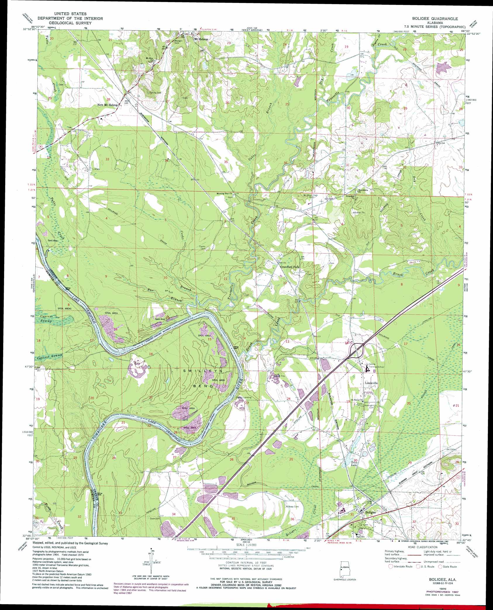
USGS Topo Quad 32088g1 - 1:24,000 scale
| Topo Map Name: | Boligee |
| USGS Topo Quad ID: | 32088g1 |
| Print Size: | ca. 21 1/4" wide x 27" high |
| Southeast Coordinates: | 32.75° N latitude / 88° W longitude |
| Map Center Coordinates: | 32.8125° N latitude / 88.0625° W longitude |
| U.S. State: | AL |
| Filename: | o32088g1.jpg |
| Download Map JPG Image: | Boligee topo map 1:24,000 scale |
| Map Type: | Topographic |
| Topo Series: | 7.5´ |
| Map Scale: | 1:24,000 |
| Source of Map Images: | United States Geological Survey (USGS) |
| Alternate Map Versions: |
Boligee AL 1970, updated 1972 Download PDF Buy paper map Boligee AL 1970, updated 1984 Download PDF Buy paper map Boligee AL 1970, updated 1987 Download PDF Buy paper map Boligee AL 2011 Download PDF Buy paper map Boligee AL 2014 Download PDF Buy paper map |
1:24,000 Topo Quads surrounding Boligee
Dancy |
Aliceville South |
Pleasant Ridge |
Mantua |
Ralph |
Panola |
Warsaw |
West Greene |
Union |
Knoxville |
Geiger |
Gainesville |
Boligee |
Eutaw |
Warrior Dam |
Emelle |
Epes West |
Epes East |
Forkland |
Mason Bend |
Boyd |
Livingston |
Brewersville |
Mcdowell |
Demopolis |
> Back to 32088e1 at 1:100,000 scale
> Back to 32088a1 at 1:250,000 scale
> Back to U.S. Topo Maps home
Boligee topo map: Gazetteer
Boligee: Bars
Blind Shoals elevation 22m 72′Brush Creek Bar elevation 30m 98′
Clays Bar elevation 22m 72′
Cubbs Creek Shoals elevation 22m 72′
Friends Bar elevation 22m 72′
Howards Bar elevation 22m 72′
Howards Lower Bar elevation 22m 72′
Jack Toms Shoals elevation 22m 72′
Toms Bar elevation 22m 72′
Trussel Shoals elevation 22m 72′
Boligee: Bends
Swilleys Bend elevation 31m 101′Boligee: Canals
Boligee Canal elevation 33m 108′Boligee: Cliffs
Clays Bluff elevation 26m 85′Boligee: Crossings
Exit 32 elevation 37m 121′Trussells Ferry (historical) elevation 29m 95′
Boligee: Lakes
Blue Lake elevation 30m 98′Horseshoe Lake (historical) elevation 31m 101′
King Lake elevation 41m 134′
Boligee: Populated Places
Boligee elevation 37m 121′Crawford Fork elevation 40m 131′
Lizzieville elevation 37m 121′
Mount Hebron elevation 81m 265′
New Mount Hebron elevation 40m 131′
Boligee: Post Offices
Boligee Post Office elevation 37m 121′Boligee: Reservoirs
Trice Lake elevation 35m 114′Boligee: Streams
Bar Branch elevation 24m 78′Brush Creek elevation 24m 78′
Cobbs Branch elevation 28m 91′
Cooks Branch elevation 24m 78′
Dry Creek elevation 33m 108′
Dry Creek elevation 33m 108′
Meeting House Branch elevation 22m 72′
Rogers Creek elevation 36m 118′
Trussells Creek elevation 22m 72′
Tubbs Creek elevation 22m 72′
Tubbs Creek elevation 24m 78′
Boligee: Summits
Solomon Hill elevation 64m 209′Boligee: Swamps
Boligee Creek Swamp elevation 34m 111′Boligee digital topo map on disk
Buy this Boligee topo map showing relief, roads, GPS coordinates and other geographical features, as a high-resolution digital map file on DVD:
Gulf Coast (LA, MS, AL, FL) & Southwestern Georgia
Buy digital topo maps: Gulf Coast (LA, MS, AL, FL) & Southwestern Georgia
 & Southwestern Georgia map DVD")