Clear Springs Topo Map Mississippi
To zoom in, hover over the map of Clear Springs
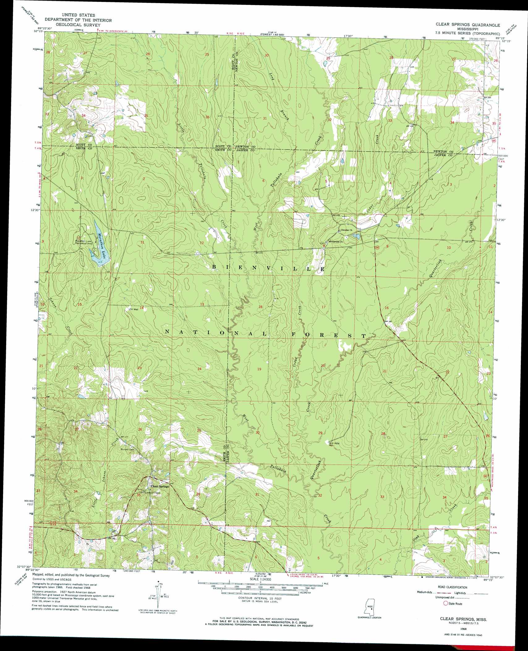
USGS Topo Quad 32089b3 - 1:24,000 scale
| Topo Map Name: | Clear Springs |
| USGS Topo Quad ID: | 32089b3 |
| Print Size: | ca. 21 1/4" wide x 27" high |
| Southeast Coordinates: | 32.125° N latitude / 89.25° W longitude |
| Map Center Coordinates: | 32.1875° N latitude / 89.3125° W longitude |
| U.S. State: | MS |
| Filename: | o32089b3.jpg |
| Download Map JPG Image: | Clear Springs topo map 1:24,000 scale |
| Map Type: | Topographic |
| Topo Series: | 7.5´ |
| Map Scale: | 1:24,000 |
| Source of Map Images: | United States Geological Survey (USGS) |
| Alternate Map Versions: |
Clear Springs MS 1968, updated 1970 Download PDF Buy paper map Clear Springs MS 2000, updated 2002 Download PDF Buy paper map Clear Springs MS 2012 Download PDF Buy paper map Clear Springs MS 2015 Download PDF Buy paper map |
| FStopo: | US Forest Service topo Clear Springs is available: Download FStopo PDF Download FStopo TIF |
1:24,000 Topo Quads surrounding Clear Springs
Hillsboro |
Harperville |
Conehatta |
Decatur Nw |
Decatur |
Pulaski |
Forest |
Lake |
Newton |
Hickory |
Homewood |
Pineville |
Clear Springs |
Montrose North |
Hero |
Raleigh |
Louin Sw |
Louin |
Montrose South |
Paulding |
Cohay |
Center Ridge |
Bay Springs |
Lake Como |
Waldrup |
> Back to 32089a1 at 1:100,000 scale
> Back to 32088a1 at 1:250,000 scale
> Back to U.S. Topo Maps home
Clear Springs topo map: Gazetteer
Clear Springs: Dams
Marathon Lake Dam elevation 126m 413′McCormick Lake Dam elevation 121m 396′
Clear Springs: Oilfields
Bienville Forest Oil Field elevation 124m 406′Clear Springs: Parks
Tallahala State Wildlife Management Area elevation 110m 360′Clear Springs: Populated Places
Clear Springs elevation 146m 479′Success (historical) elevation 119m 390′
Sun elevation 145m 475′
Clear Springs: Reservoirs
Marathon Lake elevation 125m 410′Clear Springs: Streams
Cedar Creek elevation 103m 337′Little Tallahala Creek elevation 107m 351′
Long Branch elevation 112m 367′
Quarterliah Creek elevation 103m 337′
Clear Springs digital topo map on disk
Buy this Clear Springs topo map showing relief, roads, GPS coordinates and other geographical features, as a high-resolution digital map file on DVD:
Gulf Coast (LA, MS, AL, FL) & Southwestern Georgia
Buy digital topo maps: Gulf Coast (LA, MS, AL, FL) & Southwestern Georgia
 & Southwestern Georgia map DVD")