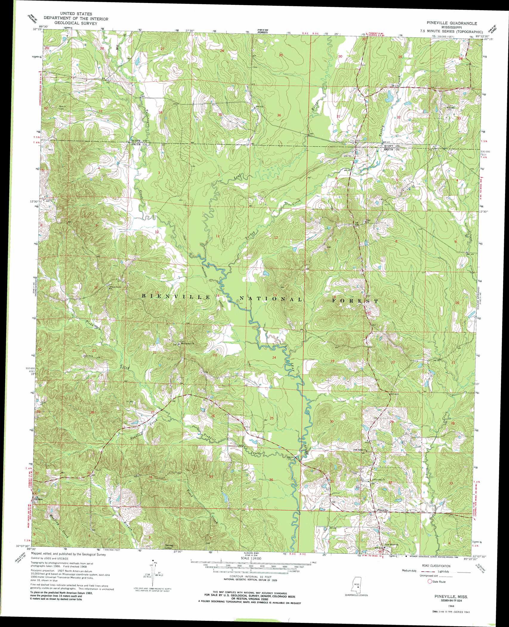
Pineville Topo Map Mississippi
To zoom in, hover over the map of Pineville
USGS Topo Quad 32089b4 - 1:24,000 scale
| Topo Map Name: | Pineville |
| USGS Topo Quad ID: | 32089b4 |
| Print Size: | ca. 21 1/4" wide x 27" high |
| Southeast Coordinates: | 32.125° N latitude / 89.375° W longitude |
| Map Center Coordinates: | 32.1875° N latitude / 89.4375° W longitude |
| U.S. State: | MS |
| Filename: | o32089b4.jpg |
| Download Map JPG Image: | Pineville topo map 1:24,000 scale |
| Map Type: | Topographic |
| Topo Series: | 7.5´ |
| Map Scale: | 1:24,000 |
| Source of Map Images: | United States Geological Survey (USGS) |
| Alternate Map Versions: |
Pineville MS 1968, updated 1970 Download PDF Buy paper map Pineville MS 1968, updated 1986 Download PDF Buy paper map Pineville MS 2000, updated 2002 Download PDF Buy paper map Pineville MS 2012 Download PDF Buy paper map Pineville MS 2015 Download PDF Buy paper map |
| FStopo: | US Forest Service topo Pineville is available: Download FStopo PDF Download FStopo TIF |
1:24,000 Topo Quads surrounding Pineville
Forkville |
Hillsboro |
Harperville |
Conehatta |
Decatur Nw |
Morton |
Pulaski |
Forest |
Lake |
Newton |
Polkville |
Homewood |
Pineville |
Clear Springs |
Montrose North |
White Oak |
Raleigh |
Louin Sw |
Louin |
Montrose South |
Magee North |
Cohay |
Center Ridge |
Bay Springs |
Lake Como |
> Back to 32089a1 at 1:100,000 scale
> Back to 32088a1 at 1:250,000 scale
> Back to U.S. Topo Maps home
Pineville topo map: Gazetteer
Pineville: Dams
O T Gilbert Pond Dam elevation 123m 403′Pineville: Populated Places
Klein elevation 129m 423′Otho elevation 130m 426′
Pineville elevation 124m 406′
Pineville: Streams
Mill Branch elevation 114m 374′Redhead Creek elevation 109m 357′
Tallabogue elevation 106m 347′
Tishkill Creek elevation 100m 328′
Turkey Creek elevation 106m 347′
Pineville digital topo map on disk
Buy this Pineville topo map showing relief, roads, GPS coordinates and other geographical features, as a high-resolution digital map file on DVD:
Gulf Coast (LA, MS, AL, FL) & Southwestern Georgia
Buy digital topo maps: Gulf Coast (LA, MS, AL, FL) & Southwestern Georgia
 & Southwestern Georgia map DVD")