Lake Topo Map Mississippi
To zoom in, hover over the map of Lake
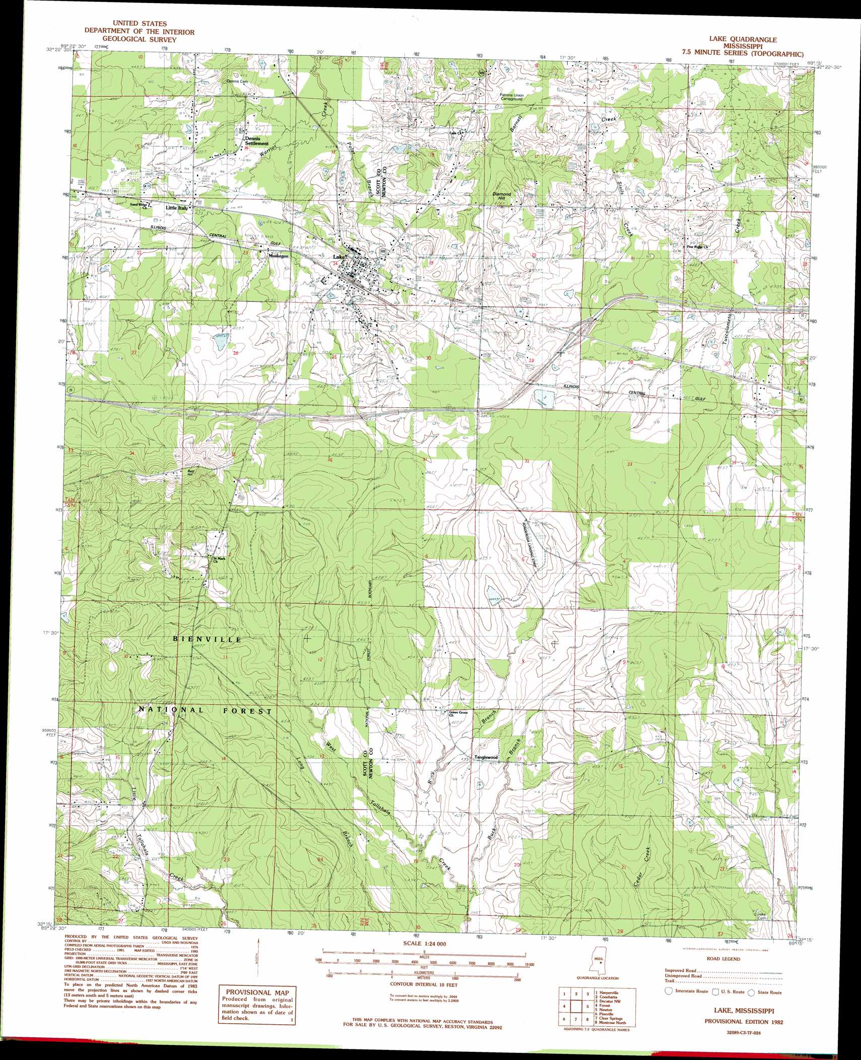
USGS Topo Quad 32089c3 - 1:24,000 scale
| Topo Map Name: | Lake |
| USGS Topo Quad ID: | 32089c3 |
| Print Size: | ca. 21 1/4" wide x 27" high |
| Southeast Coordinates: | 32.25° N latitude / 89.25° W longitude |
| Map Center Coordinates: | 32.3125° N latitude / 89.3125° W longitude |
| U.S. State: | MS |
| Filename: | o32089c3.jpg |
| Download Map JPG Image: | Lake topo map 1:24,000 scale |
| Map Type: | Topographic |
| Topo Series: | 7.5´ |
| Map Scale: | 1:24,000 |
| Source of Map Images: | United States Geological Survey (USGS) |
| Alternate Map Versions: |
Lake MS 1982, updated 1983 Download PDF Buy paper map Lake MS 2000, updated 2002 Download PDF Buy paper map Lake MS 2012 Download PDF Buy paper map Lake MS 2015 Download PDF Buy paper map |
| FStopo: | US Forest Service topo Lake is available: Download FStopo PDF Download FStopo TIF |
1:24,000 Topo Quads surrounding Lake
Lena |
Walnut Grove |
Sebastopol |
Union West |
Union East |
Hillsboro |
Harperville |
Conehatta |
Decatur Nw |
Decatur |
Pulaski |
Forest |
Lake |
Newton |
Hickory |
Homewood |
Pineville |
Clear Springs |
Montrose North |
Hero |
Raleigh |
Louin Sw |
Louin |
Montrose South |
Paulding |
> Back to 32089a1 at 1:100,000 scale
> Back to 32088a1 at 1:250,000 scale
> Back to U.S. Topo Maps home
Lake topo map: Gazetteer
Lake: Crossings
Interchange 100 elevation 140m 459′Interchange 96 elevation 142m 465′
Lake: Dams
Earl Davis Pond Dam elevation 138m 452′Stovall Lake Dam elevation 131m 429′
Lake: Populated Places
Ball Hill elevation 180m 590′Bartlett elevation 131m 429′
Buckleytown elevation 147m 482′
Dennis Settlement elevation 132m 433′
Lake elevation 134m 439′
Little Italy elevation 128m 419′
Muskegon elevation 130m 426′
Patrons Union (historical) elevation 135m 442′
Tanglewood elevation 130m 426′
Lake: Streams
Barnett Creek elevation 127m 416′Buck Branch elevation 118m 387′
Polar Branch elevation 123m 403′
Riley Branch elevation 119m 390′
Sivils Creek elevation 127m 416′
Lake: Summits
Bald Hill elevation 181m 593′Diamond Hill elevation 139m 456′
Lake digital topo map on disk
Buy this Lake topo map showing relief, roads, GPS coordinates and other geographical features, as a high-resolution digital map file on DVD:
Gulf Coast (LA, MS, AL, FL) & Southwestern Georgia
Buy digital topo maps: Gulf Coast (LA, MS, AL, FL) & Southwestern Georgia
 & Southwestern Georgia map DVD")