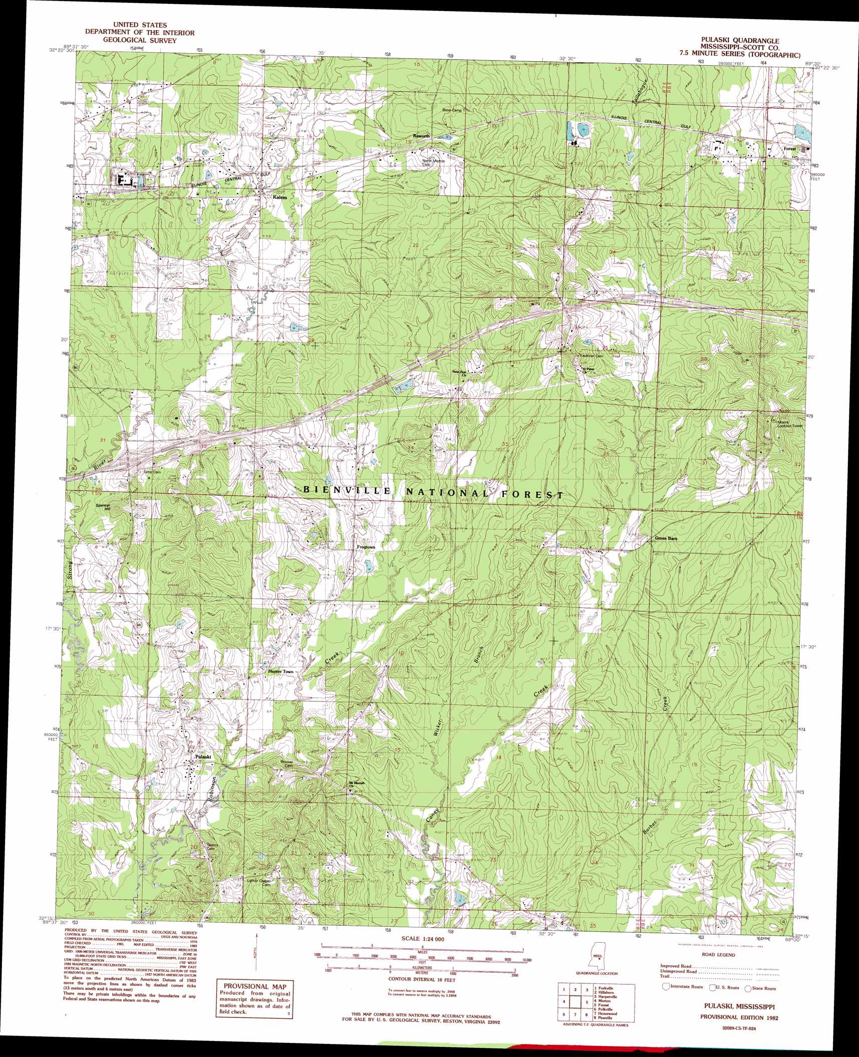
Pulaski Topo Map Mississippi
To zoom in, hover over the map of Pulaski
USGS Topo Quad 32089c5 - 1:24,000 scale
| Topo Map Name: | Pulaski |
| USGS Topo Quad ID: | 32089c5 |
| Print Size: | ca. 21 1/4" wide x 27" high |
| Southeast Coordinates: | 32.25° N latitude / 89.5° W longitude |
| Map Center Coordinates: | 32.3125° N latitude / 89.5625° W longitude |
| U.S. State: | MS |
| Filename: | o32089c5.jpg |
| Download Map JPG Image: | Pulaski topo map 1:24,000 scale |
| Map Type: | Topographic |
| Topo Series: | 7.5´ |
| Map Scale: | 1:24,000 |
| Source of Map Images: | United States Geological Survey (USGS) |
| Alternate Map Versions: |
Pulaski MS 1982, updated 1983 Download PDF Buy paper map Pulaski MS 2000, updated 2002 Download PDF Buy paper map Pulaski MS 2012 Download PDF Buy paper map Pulaski MS 2015 Download PDF Buy paper map |
| FStopo: | US Forest Service topo Pulaski is available: Download FStopo PDF Download FStopo TIF |
1:24,000 Topo Quads surrounding Pulaski
Sharon Se |
Ludlow |
Lena |
Walnut Grove |
Sebastopol |
Leesburg |
Forkville |
Hillsboro |
Harperville |
Conehatta |
Pelahatchie |
Morton |
Pulaski |
Forest |
Lake |
Johns |
Polkville |
Homewood |
Pineville |
Clear Springs |
Puckett |
White Oak |
Raleigh |
Louin Sw |
Louin |
> Back to 32089a1 at 1:100,000 scale
> Back to 32088a1 at 1:250,000 scale
> Back to U.S. Topo Maps home
Pulaski topo map: Gazetteer
Pulaski: Crossings
Interchange 80 elevation 133m 436′Pulaski: Dams
Buster Lackey Pond Dam elevation 137m 449′Central By-Products Sewage Lagoon Dam elevation 145m 475′
Central By-Products Sewage Lagoon Dam elevation 146m 479′
Pulaski: Forests
Bienville National Forest elevation 140m 459′Pulaski: Populated Places
Frogtown elevation 137m 449′Hunter Town elevation 129m 423′
Kalem elevation 137m 449′
Pulaski elevation 127m 416′
Raworth elevation 152m 498′
Pulaski: Streams
Morehead Creek elevation 117m 383′Wicker Branch elevation 122m 400′
Pulaski: Summits
Spencer Hill elevation 150m 492′Pulaski digital topo map on disk
Buy this Pulaski topo map showing relief, roads, GPS coordinates and other geographical features, as a high-resolution digital map file on DVD:
Gulf Coast (LA, MS, AL, FL) & Southwestern Georgia
Buy digital topo maps: Gulf Coast (LA, MS, AL, FL) & Southwestern Georgia
 & Southwestern Georgia map DVD")