Goshen Springs Topo Map Mississippi
To zoom in, hover over the map of Goshen Springs
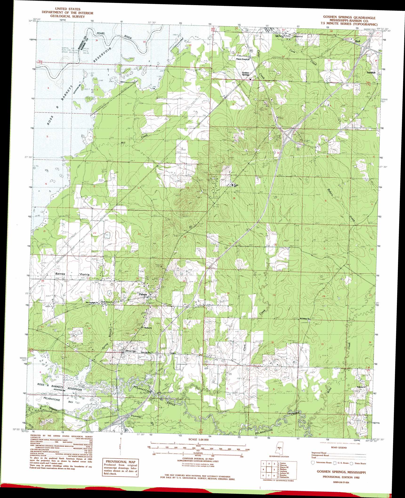
USGS Topo Quad 32089d8 - 1:24,000 scale
| Topo Map Name: | Goshen Springs |
| USGS Topo Quad ID: | 32089d8 |
| Print Size: | ca. 21 1/4" wide x 27" high |
| Southeast Coordinates: | 32.375° N latitude / 89.875° W longitude |
| Map Center Coordinates: | 32.4375° N latitude / 89.9375° W longitude |
| U.S. State: | MS |
| Filename: | o32089d8.jpg |
| Download Map JPG Image: | Goshen Springs topo map 1:24,000 scale |
| Map Type: | Topographic |
| Topo Series: | 7.5´ |
| Map Scale: | 1:24,000 |
| Source of Map Images: | United States Geological Survey (USGS) |
| Alternate Map Versions: |
Goshen Springs MS 1982, updated 1983 Download PDF Buy paper map Goshen Springs MS 2012 Download PDF Buy paper map Goshen Springs MS 2015 Download PDF Buy paper map |
1:24,000 Topo Quads surrounding Goshen Springs
Berryville |
Way |
Sharon |
Farmhaven |
Ofahoma |
Charlton |
Canton |
Shoccoe |
Sharon Se |
Ludlow |
Ridgeland |
Madison |
Goshen Springs |
Leesburg |
Forkville |
Jackson |
Jackson Se |
Brandon |
Pelahatchie |
Morton |
Florence |
Whitfield |
Puckett Nw |
Johns |
Polkville |
> Back to 32089a1 at 1:100,000 scale
> Back to 32088a1 at 1:250,000 scale
> Back to U.S. Topo Maps home
Goshen Springs topo map: Gazetteer
Goshen Springs: Dams
McWrights Lake Dam elevation 97m 318′Sherrils Lake Dam elevation 108m 354′
Goshen Springs: Flats
Barnes Prairie elevation 101m 331′Hills Prairie elevation 104m 341′
Goshen Springs: Lakes
Cypress Lake elevation 89m 291′Goshen Springs: Populated Places
Fannin elevation 117m 383′Goshen Springs elevation 128m 419′
Koch elevation 104m 341′
New Fannin elevation 100m 328′
Sand Hill elevation 107m 351′
Sunrise Point elevation 92m 301′
Waterwood elevation 91m 298′
Goshen Springs: Springs
Samuel Spring elevation 103m 337′Goshen Springs: Streams
Bakers Creek elevation 100m 328′Clark Creek elevation 92m 301′
Mill Creek elevation 89m 291′
Plummer Slu elevation 89m 291′
Riley Creek elevation 91m 298′
Saddlebag Creek elevation 89m 291′
Spring Branch elevation 89m 291′
Goshen Springs digital topo map on disk
Buy this Goshen Springs topo map showing relief, roads, GPS coordinates and other geographical features, as a high-resolution digital map file on DVD:
Gulf Coast (LA, MS, AL, FL) & Southwestern Georgia
Buy digital topo maps: Gulf Coast (LA, MS, AL, FL) & Southwestern Georgia
 & Southwestern Georgia map DVD")