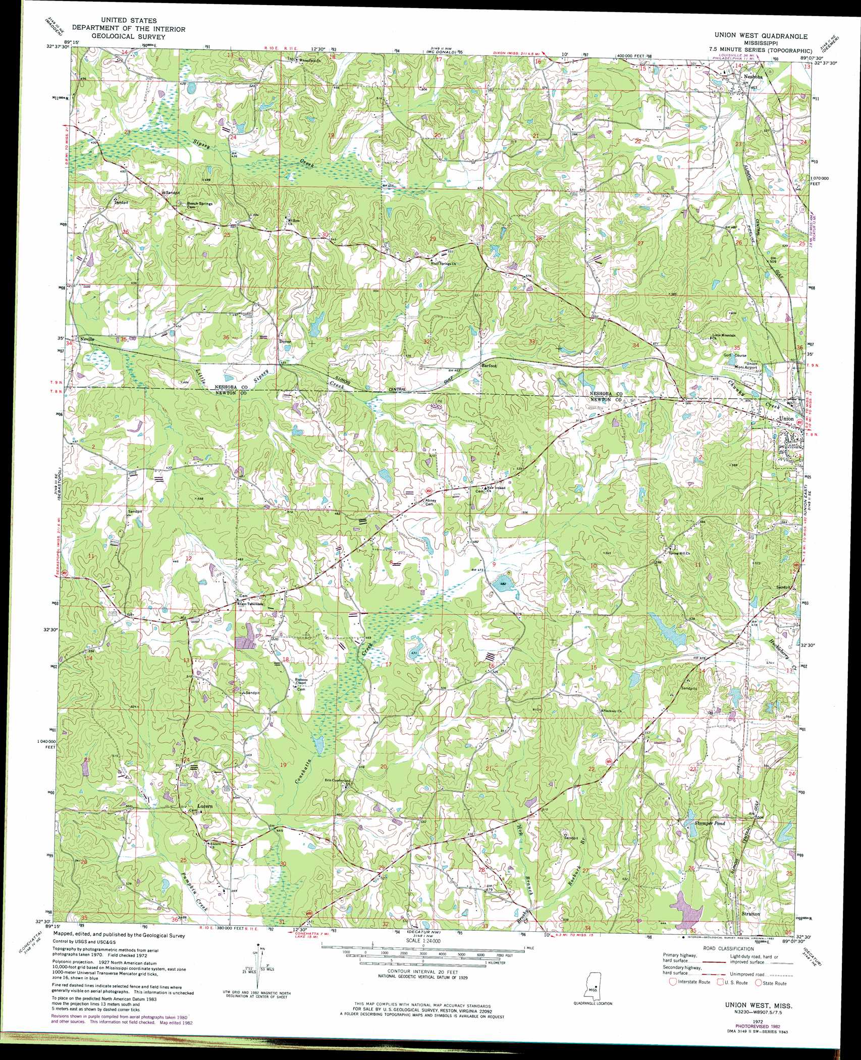
Union West Topo Map Mississippi
To zoom in, hover over the map of Union West
USGS Topo Quad 32089e2 - 1:24,000 scale
| Topo Map Name: | Union West |
| USGS Topo Quad ID: | 32089e2 |
| Print Size: | ca. 21 1/4" wide x 27" high |
| Southeast Coordinates: | 32.5° N latitude / 89.125° W longitude |
| Map Center Coordinates: | 32.5625° N latitude / 89.1875° W longitude |
| U.S. State: | MS |
| Filename: | o32089e2.jpg |
| Download Map JPG Image: | Union West topo map 1:24,000 scale |
| Map Type: | Topographic |
| Topo Series: | 7.5´ |
| Map Scale: | 1:24,000 |
| Source of Map Images: | United States Geological Survey (USGS) |
| Alternate Map Versions: |
Union West MS 1972, updated 1973 Download PDF Buy paper map Union West MS 1972, updated 1982 Download PDF Buy paper map Union West MS 2012 Download PDF Buy paper map Union West MS 2015 Download PDF Buy paper map |
1:24,000 Topo Quads surrounding Union West
Renfroe |
Edinburg |
Pearl River |
Philadelphia |
Owl Creek |
Mcafee |
Madden |
Mcdonald |
Deemer |
House |
Walnut Grove |
Sebastopol |
Union West |
Union East |
Post |
Harperville |
Conehatta |
Decatur Nw |
Decatur |
Duffee |
Forest |
Lake |
Newton |
Hickory |
Chunky |
> Back to 32089e1 at 1:100,000 scale
> Back to 32088a1 at 1:250,000 scale
> Back to U.S. Topo Maps home
Union West topo map: Gazetteer
Union West: Airports
Union Municipal Airport elevation 156m 511′Union West: Dams
Chunky River Watershed 47 Dam elevation 132m 433′Doctor Laird Lake Dam elevation 146m 479′
Dooley Lake Dam elevation 138m 452′
Earl Laird Lake Dam elevation 147m 482′
Henry Lake Dam elevation 153m 501′
Mississippi No Name 228 Dam elevation 138m 452′
P Measells Lake Dam elevation 145m 475′
T Herd Lake Dam elevation 140m 459′
Union West: Lakes
Stamper Pond elevation 141m 462′Union West: Populated Places
Barfoot elevation 146m 479′Dover elevation 145m 475′
Lucern elevation 153m 501′
Neshoba elevation 152m 498′
Neville elevation 128m 419′
New Ireland elevation 159m 521′
Oka Kapassa (historical) elevation 171m 561′
Stamper (historical) elevation 140m 459′
Union West: Springs
Gum Spring elevation 151m 495′Union West: Streams
Fulton Creek elevation 135m 442′Hog Branch elevation 140m 459′
Roebuck Branch elevation 140m 459′
Union West digital topo map on disk
Buy this Union West topo map showing relief, roads, GPS coordinates and other geographical features, as a high-resolution digital map file on DVD:
Gulf Coast (LA, MS, AL, FL) & Southwestern Georgia
Buy digital topo maps: Gulf Coast (LA, MS, AL, FL) & Southwestern Georgia
 & Southwestern Georgia map DVD")