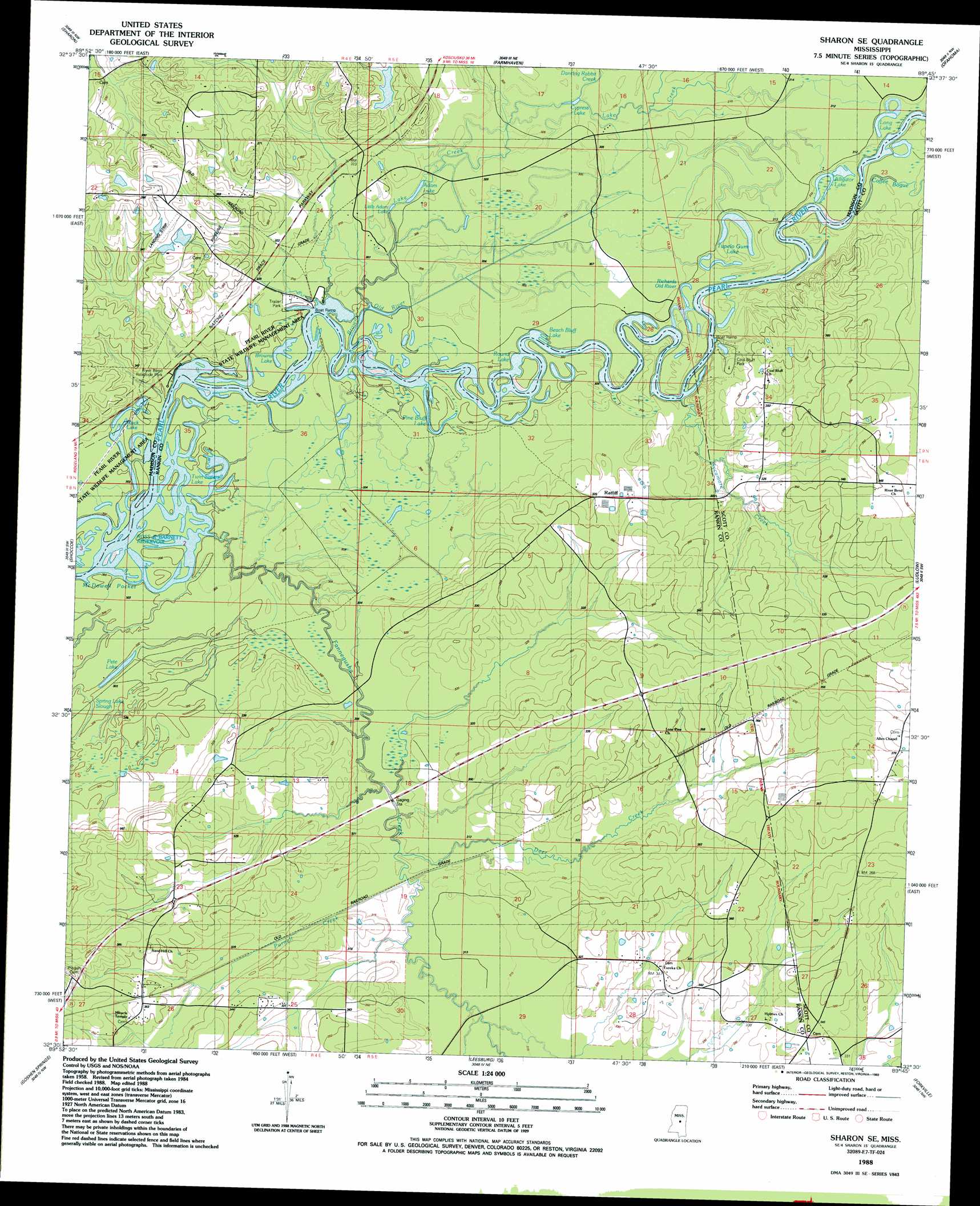
Sharon Se Topo Map Mississippi
To zoom in, hover over the map of Sharon Se
USGS Topo Quad 32089e7 - 1:24,000 scale
| Topo Map Name: | Sharon Se |
| USGS Topo Quad ID: | 32089e7 |
| Print Size: | ca. 21 1/4" wide x 27" high |
| Southeast Coordinates: | 32.5° N latitude / 89.75° W longitude |
| Map Center Coordinates: | 32.5625° N latitude / 89.8125° W longitude |
| U.S. State: | MS |
| Filename: | o32089e7.jpg |
| Download Map JPG Image: | Sharon Se topo map 1:24,000 scale |
| Map Type: | Topographic |
| Topo Series: | 7.5´ |
| Map Scale: | 1:24,000 |
| Source of Map Images: | United States Geological Survey (USGS) |
| Alternate Map Versions: |
Sharon SE MS 1988, updated 1989 Download PDF Buy paper map Sharon SE MS 2012 Download PDF Buy paper map Sharon SE MS 2015 Download PDF Buy paper map |
1:24,000 Topo Quads surrounding Sharon Se
Vaughan |
Cameron |
Camden |
Thomastown |
Conway |
Way |
Sharon |
Farmhaven |
Ofahoma |
Carthage |
Canton |
Shoccoe |
Sharon Se |
Ludlow |
Lena |
Madison |
Goshen Springs |
Leesburg |
Forkville |
Hillsboro |
Jackson Se |
Brandon |
Pelahatchie |
Morton |
Pulaski |
> Back to 32089e1 at 1:100,000 scale
> Back to 32088a1 at 1:250,000 scale
> Back to U.S. Topo Maps home
Sharon Se topo map: Gazetteer
Sharon Se: Crossings
Ratliffs Ferry (historical) elevation 91m 298′Sharon Se: Lakes
Adam Lake elevation 91m 298′Alligator Lake elevation 91m 298′
Beach Bluff Lake elevation 91m 298′
Black Lake elevation 91m 298′
Browns Lake elevation 91m 298′
Cypress Lake elevation 91m 298′
Little Adam Lake elevation 93m 305′
Long Lake elevation 93m 305′
Pete Lake elevation 91m 298′
Pine Bluff Lake elevation 91m 298′
Richards Old River elevation 91m 298′
Round Lake elevation 91m 298′
Twin Sisters Lake elevation 91m 298′
Sharon Se: Parks
Coal Bluff Park elevation 101m 331′Sharon Se: Populated Places
Eureka elevation 104m 341′Forty (historical) elevation 110m 360′
Ophelia (historical) elevation 103m 337′
Ratliff elevation 100m 328′
Sharon Se: Streams
Browns Old River elevation 91m 298′Coffee Bogue elevation 91m 298′
Dancing Rabbit Creek elevation 93m 305′
Deer Creek elevation 95m 311′
Fannegusha Creek elevation 89m 291′
Lake Creek elevation 91m 298′
Purnell Creek elevation 93m 305′
Rollison Creek elevation 94m 308′
Sycamore Creek elevation 91m 298′
Sharon Se: Swamps
Tupelo Gum Lake elevation 94m 308′Sharon Se digital topo map on disk
Buy this Sharon Se topo map showing relief, roads, GPS coordinates and other geographical features, as a high-resolution digital map file on DVD:
Gulf Coast (LA, MS, AL, FL) & Southwestern Georgia
Buy digital topo maps: Gulf Coast (LA, MS, AL, FL) & Southwestern Georgia
 & Southwestern Georgia map DVD")