Philadelphia Topo Map Mississippi
To zoom in, hover over the map of Philadelphia
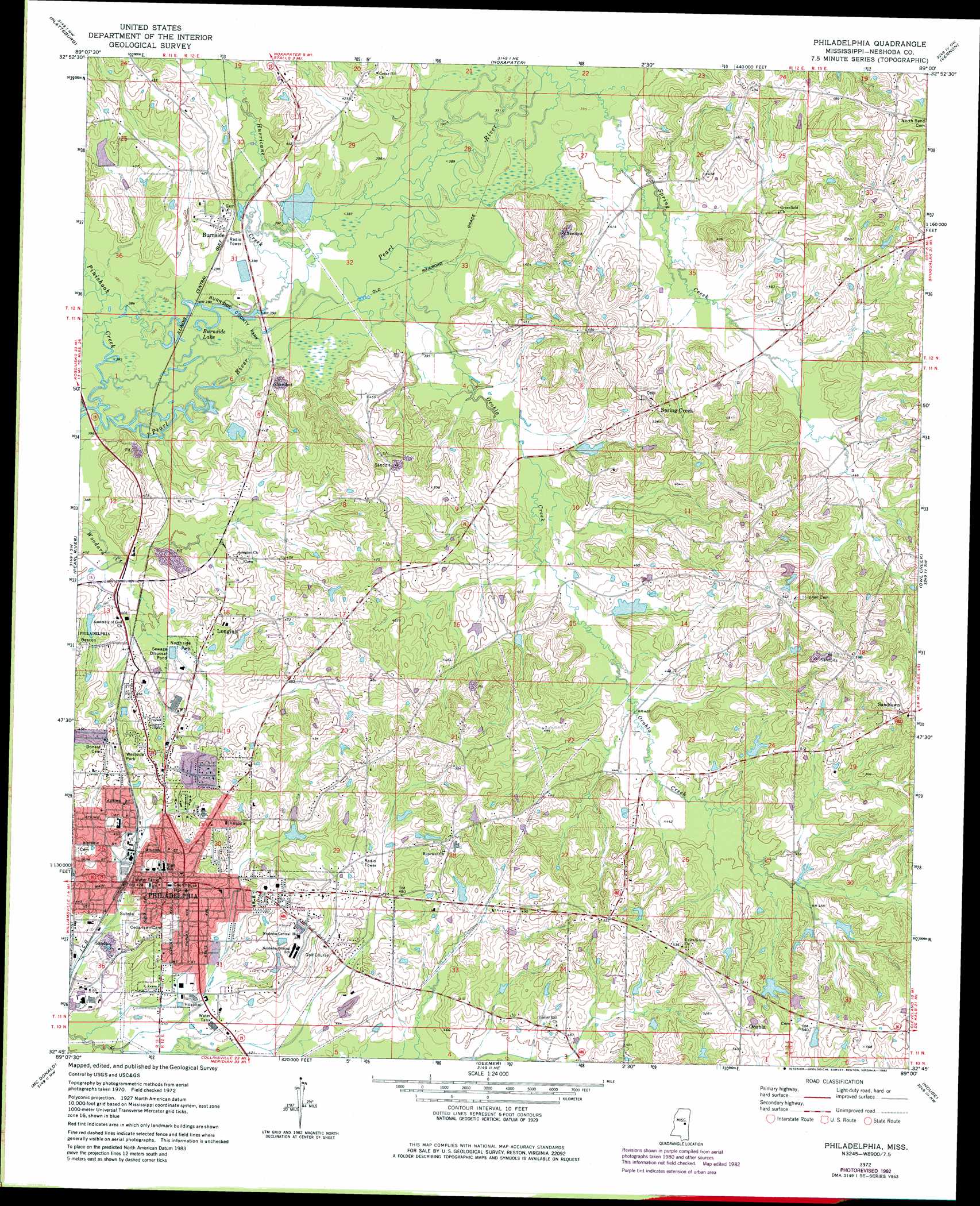
USGS Topo Quad 32089g1 - 1:24,000 scale
| Topo Map Name: | Philadelphia |
| USGS Topo Quad ID: | 32089g1 |
| Print Size: | ca. 21 1/4" wide x 27" high |
| Southeast Coordinates: | 32.75° N latitude / 89° W longitude |
| Map Center Coordinates: | 32.8125° N latitude / 89.0625° W longitude |
| U.S. State: | MS |
| Filename: | o32089g1.jpg |
| Download Map JPG Image: | Philadelphia topo map 1:24,000 scale |
| Map Type: | Topographic |
| Topo Series: | 7.5´ |
| Map Scale: | 1:24,000 |
| Source of Map Images: | United States Geological Survey (USGS) |
| Alternate Map Versions: |
Philadelphia MS 1972, updated 1973 Download PDF Buy paper map Philadelphia MS 1972, updated 1982 Download PDF Buy paper map Philadelphia MS 2012 Download PDF Buy paper map Philadelphia MS 2015 Download PDF Buy paper map |
1:24,000 Topo Quads surrounding Philadelphia
Ethel Se |
Louisville Sw |
Louisville South |
Boon |
Fearns Springs |
Four Corners |
Plattsburg |
Noxapater |
Vernon |
Preston |
Edinburg |
Pearl River |
Philadelphia |
Owl Creek |
Lynville |
Madden |
Mcdonald |
Deemer |
House |
Moscow |
Sebastopol |
Union West |
Union East |
Post |
Center Hill |
> Back to 32089e1 at 1:100,000 scale
> Back to 32088a1 at 1:250,000 scale
> Back to U.S. Topo Maps home
Philadelphia topo map: Gazetteer
Philadelphia: Crossings
Ross Ferry (historical) elevation 116m 380′Philadelphia: Dams
Colonel Eubanks Lake Dam elevation 128m 419′Country Club Lake Dam elevation 138m 452′
Jack Weatherford Lake Dam elevation 128m 419′
John Morrow Lake Dam elevation 143m 469′
Marshall Lake Dam elevation 150m 492′
Mrs Jesse Cox Lake Dam elevation 134m 439′
Pearl Harrison Lake Dam elevation 151m 495′
Q Copeland Lake Dam elevation 149m 488′
T Cook Pond Dam elevation 145m 475′
Weatherford Lake Dam elevation 143m 469′
Yates Lake Dam elevation 117m 383′
Philadelphia: Lakes
Big Lake (historical) elevation 119m 390′Burnside Lake elevation 117m 383′
Philadelphia: Parks
Burnside County Park elevation 119m 390′Dewitt-Deweese Memorial Park elevation 140m 459′
Northside Park elevation 124m 406′
Westside Park elevation 143m 469′
Philadelphia: Populated Places
Burnside elevation 122m 400′Longino elevation 138m 452′
Ocobla elevation 163m 534′
Philadelphia elevation 128m 419′
Sandtown elevation 180m 590′
Spring Creek elevation 152m 498′
Philadelphia: Post Offices
Philadelphia Post Office elevation 153m 501′Philadelphia: Streams
Hurricane Creek elevation 117m 383′Ocobla Creek elevation 117m 383′
Pinishook Creek elevation 115m 377′
Spring Creek elevation 119m 390′
Philadelphia digital topo map on disk
Buy this Philadelphia topo map showing relief, roads, GPS coordinates and other geographical features, as a high-resolution digital map file on DVD:
Gulf Coast (LA, MS, AL, FL) & Southwestern Georgia
Buy digital topo maps: Gulf Coast (LA, MS, AL, FL) & Southwestern Georgia
 & Southwestern Georgia map DVD")