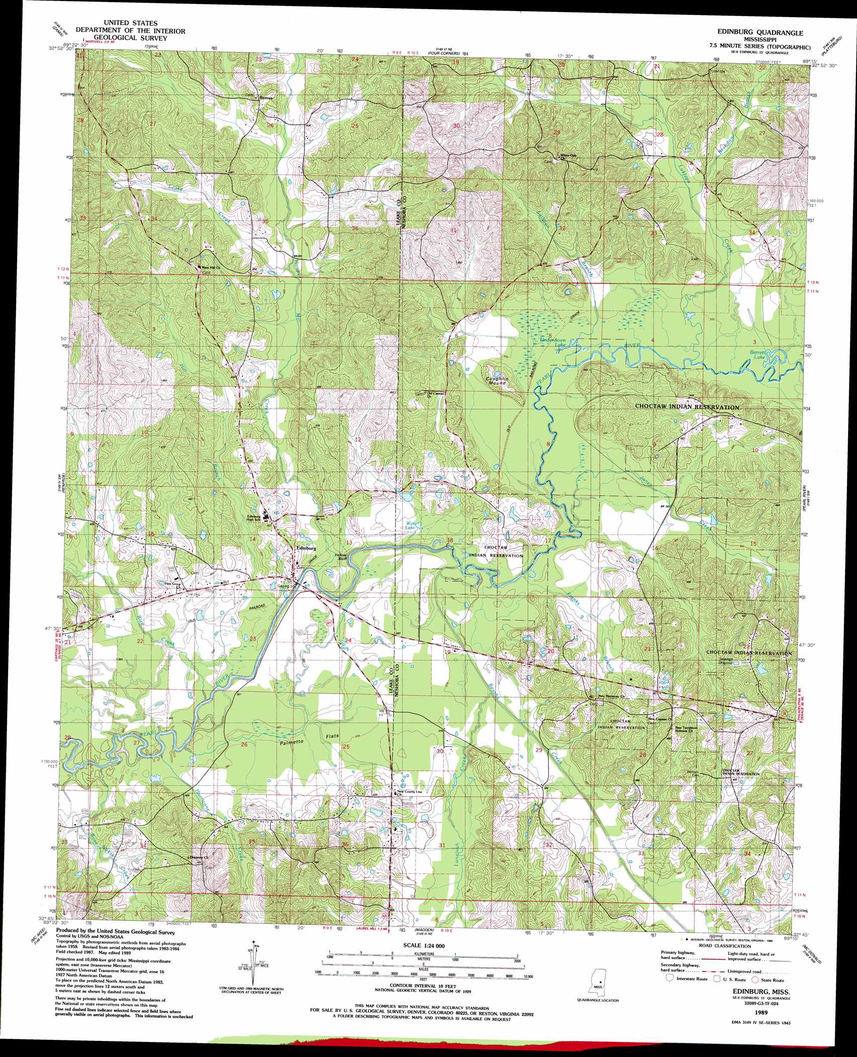
Edinburg Topo Map Mississippi
To zoom in, hover over the map of Edinburg
USGS Topo Quad 32089g3 - 1:24,000 scale
| Topo Map Name: | Edinburg |
| USGS Topo Quad ID: | 32089g3 |
| Print Size: | ca. 21 1/4" wide x 27" high |
| Southeast Coordinates: | 32.75° N latitude / 89.25° W longitude |
| Map Center Coordinates: | 32.8125° N latitude / 89.3125° W longitude |
| U.S. State: | MS |
| Filename: | o32089g3.jpg |
| Download Map JPG Image: | Edinburg topo map 1:24,000 scale |
| Map Type: | Topographic |
| Topo Series: | 7.5´ |
| Map Scale: | 1:24,000 |
| Source of Map Images: | United States Geological Survey (USGS) |
| Alternate Map Versions: |
Edinburg MS 1989, updated 1989 Download PDF Buy paper map Edinburg MS 2012 Download PDF Buy paper map Edinburg MS 2015 Download PDF Buy paper map |
1:24,000 Topo Quads surrounding Edinburg
Kosciusko |
Ethel South |
Ethel Se |
Louisville Sw |
Louisville South |
Singleton |
Zama |
Four Corners |
Plattsburg |
Noxapater |
Conway |
Renfroe |
Edinburg |
Pearl River |
Philadelphia |
Carthage |
Mcafee |
Madden |
Mcdonald |
Deemer |
Lena |
Walnut Grove |
Sebastopol |
Union West |
Union East |
> Back to 32089e1 at 1:100,000 scale
> Back to 32088a1 at 1:250,000 scale
> Back to U.S. Topo Maps home
Edinburg topo map: Gazetteer
Edinburg: Cliffs
Yellow Bluff elevation 106m 347′Edinburg: Dams
Indian Reservation Lake Dam elevation 128m 419′Norman Johnson Lake Dam elevation 140m 459′
Thompson Lake Dam elevation 149m 488′
Edinburg: Flats
Palmetto Flats elevation 112m 367′Edinburg: Lakes
Barrett Lake elevation 110m 360′Underdown Lake elevation 111m 364′
Wye Lake elevation 111m 364′
Edinburg: Populated Places
Ebenezer elevation 152m 498′Edinburg elevation 115m 377′
Remus elevation 142m 465′
Edinburg: Streams
Beasha Creek elevation 107m 351′Bose Nukse Creek elevation 105m 344′
Brandon Branch elevation 116m 380′
Franks Branch elevation 110m 360′
Hill Branch elevation 112m 367′
Hooper Mill Creek elevation 106m 347′
Hurricane Creek elevation 103m 337′
Jones Creek elevation 109m 357′
Leake Creek elevation 118m 387′
Lukfapa Creek elevation 110m 360′
Luneluah Creek elevation 113m 370′
Rice Creek elevation 106m 347′
Sullivan Branch elevation 110m 360′
Edinburg: Summits
Coughlin Mound elevation 125m 410′Edinburg digital topo map on disk
Buy this Edinburg topo map showing relief, roads, GPS coordinates and other geographical features, as a high-resolution digital map file on DVD:
Gulf Coast (LA, MS, AL, FL) & Southwestern Georgia
Buy digital topo maps: Gulf Coast (LA, MS, AL, FL) & Southwestern Georgia
 & Southwestern Georgia map DVD")