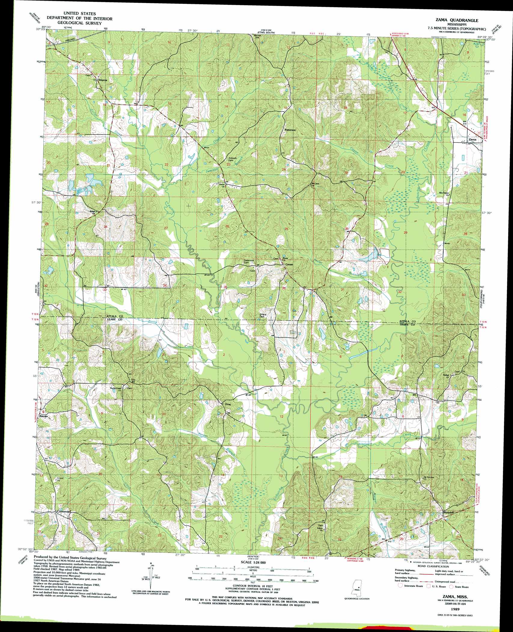
Zama Topo Map Mississippi
To zoom in, hover over the map of Zama
USGS Topo Quad 32089h4 - 1:24,000 scale
| Topo Map Name: | Zama |
| USGS Topo Quad ID: | 32089h4 |
| Print Size: | ca. 21 1/4" wide x 27" high |
| Southeast Coordinates: | 32.875° N latitude / 89.375° W longitude |
| Map Center Coordinates: | 32.9375° N latitude / 89.4375° W longitude |
| U.S. State: | MS |
| Filename: | o32089h4.jpg |
| Download Map JPG Image: | Zama topo map 1:24,000 scale |
| Map Type: | Topographic |
| Topo Series: | 7.5´ |
| Map Scale: | 1:24,000 |
| Source of Map Images: | United States Geological Survey (USGS) |
| Alternate Map Versions: |
Zama MS 1989, updated 1989 Download PDF Buy paper map Zama MS 2012 Download PDF Buy paper map Zama MS 2015 Download PDF Buy paper map |
1:24,000 Topo Quads surrounding Zama
Hesterville |
Kosciusko Ne |
Ethel North |
Mccool |
Highpoint |
Mcadams |
Kosciusko |
Ethel South |
Ethel Se |
Louisville Sw |
Joseph |
Singleton |
Zama |
Four Corners |
Plattsburg |
Thomastown |
Conway |
Renfroe |
Edinburg |
Pearl River |
Ofahoma |
Carthage |
Mcafee |
Madden |
Mcdonald |
> Back to 32089e1 at 1:100,000 scale
> Back to 32088a1 at 1:250,000 scale
> Back to U.S. Topo Maps home
Zama topo map: Gazetteer
Zama: Dams
Gregory Lake Dam elevation 121m 396′Jim Hudgins Pond Dam elevation 116m 380′
Sandridge Lake Dam elevation 137m 449′
Zama: Populated Places
Beulah (historical) elevation 162m 531′Center elevation 149m 488′
Crossroad elevation 158m 518′
Gray elevation 144m 472′
Marydell elevation 148m 485′
Patterson elevation 156m 511′
Smyrna elevation 155m 508′
Zama elevation 127m 416′
Zama: Streams
Archie Creek elevation 122m 400′Bibalucta Creek elevation 114m 374′
Canna Creek elevation 119m 390′
Chestnut Creek elevation 124m 406′
Fuller Creek elevation 127m 416′
Harper Branch elevation 119m 390′
Jamison Branch elevation 127m 416′
Kenty Creek elevation 116m 380′
Pailey Creek elevation 116m 380′
Parker Branch elevation 115m 377′
Peeler Branch elevation 119m 390′
Zama digital topo map on disk
Buy this Zama topo map showing relief, roads, GPS coordinates and other geographical features, as a high-resolution digital map file on DVD:
Gulf Coast (LA, MS, AL, FL) & Southwestern Georgia
Buy digital topo maps: Gulf Coast (LA, MS, AL, FL) & Southwestern Georgia
 & Southwestern Georgia map DVD")