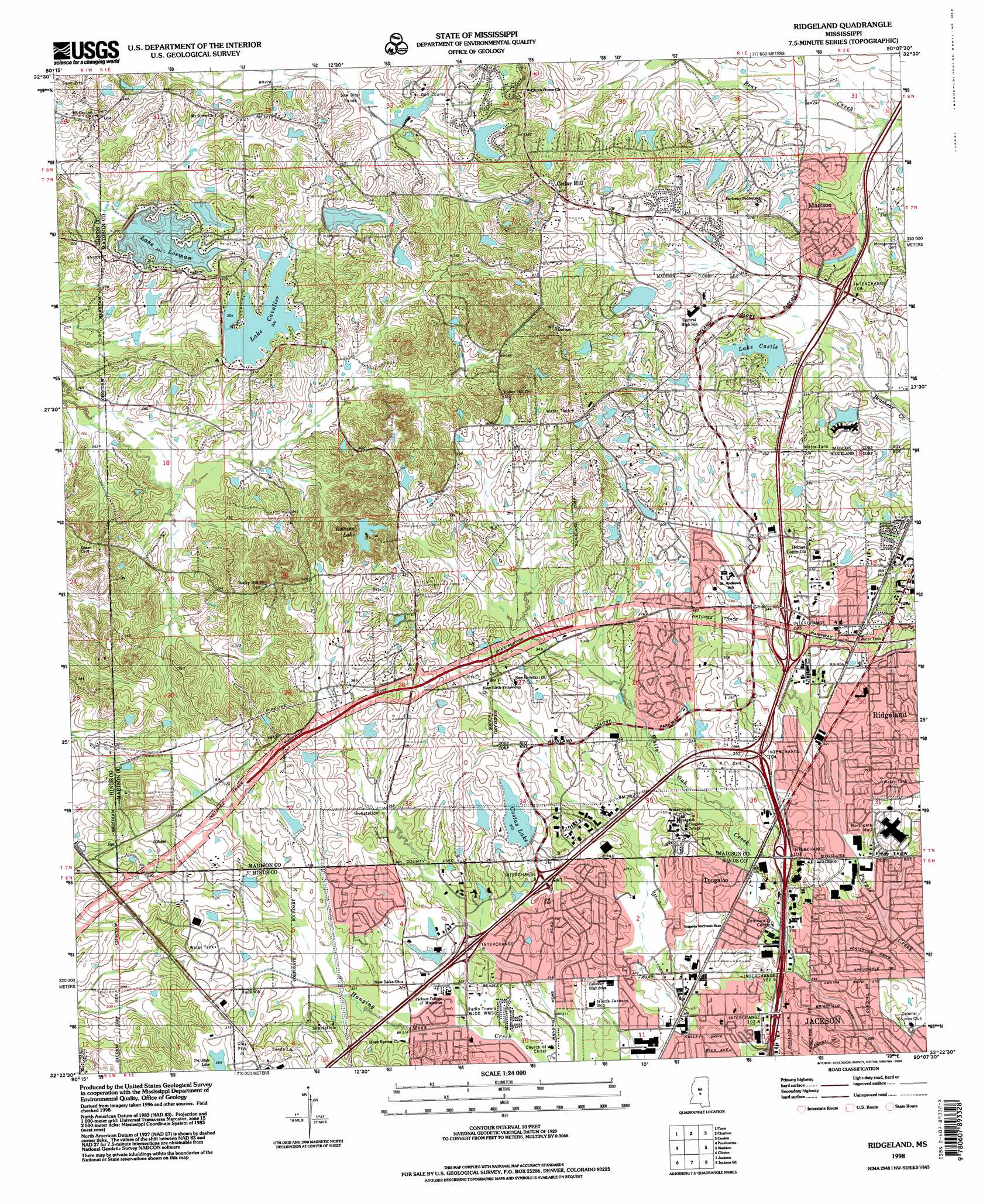
Ridgeland Topo Map Mississippi
To zoom in, hover over the map of Ridgeland
USGS Topo Quad 32090d2 - 1:24,000 scale
| Topo Map Name: | Ridgeland |
| USGS Topo Quad ID: | 32090d2 |
| Print Size: | ca. 21 1/4" wide x 27" high |
| Southeast Coordinates: | 32.375° N latitude / 90.125° W longitude |
| Map Center Coordinates: | 32.4375° N latitude / 90.1875° W longitude |
| U.S. State: | MS |
| Filename: | o32090d2.jpg |
| Download Map JPG Image: | Ridgeland topo map 1:24,000 scale |
| Map Type: | Topographic |
| Topo Series: | 7.5´ |
| Map Scale: | 1:24,000 |
| Source of Map Images: | United States Geological Survey (USGS) |
| Alternate Map Versions: |
Ridgeland MS 1963, updated 1964 Download PDF Buy paper map Ridgeland MS 1963, updated 1971 Download PDF Buy paper map Ridgeland MS 1963, updated 1972 Download PDF Buy paper map Ridgeland MS 1980, updated 1980 Download PDF Buy paper map Ridgeland MS 1980, updated 1986 Download PDF Buy paper map Ridgeland MS 1980, updated 1986 Download PDF Buy paper map Ridgeland MS 1998, updated 1998 Download PDF Buy paper map Ridgeland MS 2012 Download PDF Buy paper map Ridgeland MS 2015 Download PDF Buy paper map |
1:24,000 Topo Quads surrounding Ridgeland
Tinsley |
Bentonia |
Berryville |
Way |
Sharon |
Coxs Ferry |
Flora |
Charlton |
Canton |
Shoccoe |
Brownsville |
Pocahontas |
Ridgeland |
Madison |
Goshen Springs |
Raymond |
Clinton |
Jackson |
Jackson Se |
Brandon |
Terry Nw |
New Byram |
Florence |
Whitfield |
Puckett Nw |
> Back to 32090a1 at 1:100,000 scale
> Back to 32090a1 at 1:250,000 scale
> Back to U.S. Topo Maps home
Ridgeland topo map: Gazetteer
Ridgeland: Crossings
Interchange 102 elevation 97m 318′Interchange 103 elevation 99m 324′
Interchange 104 elevation 106m 347′
Interchange 105A elevation 106m 347′
Interchange 105B elevation 110m 360′
Interchange 108 elevation 107m 351′
Interchange 8 elevation 104m 341′
Interchange 9 elevation 106m 347′
Ridgeland: Dams
Costas Lake Dam elevation 106m 347′J A Greco Lake Dam elevation 98m 321′
J T Canizaro Dam elevation 109m 357′
L C Gallett Lake Dam elevation 111m 364′
Lake Castle Dam elevation 107m 351′
Lake Cavalier Dam elevation 89m 291′
Lake LaRue Dam elevation 95m 311′
Lake Lorman Dam elevation 88m 288′
Little Costas Lake Dam elevation 110m 360′
Madison City Lake Dam elevation 98m 321′
R E Cheatham Lake Dam elevation 108m 354′
Ridgeland City Lake Dam elevation 104m 341′
Salomon Green Lake Dam elevation 110m 360′
W E Morse Lake Dam elevation 106m 347′
Wallace Harrison Lake Dam elevation 84m 275′
Ridgeland: Populated Places
Cedar Hill elevation 122m 400′Cynthia elevation 100m 328′
Greenbrook elevation 100m 328′
Hope Springs elevation 98m 321′
Lakeover elevation 106m 347′
New Hope Grove elevation 119m 390′
North Colony elevation 100m 328′
Norwood elevation 92m 301′
Ridgeland elevation 109m 357′
Robinson Springs elevation 99m 324′
Squirrel Hill elevation 111m 364′
Summertree elevation 109m 357′
Tougaloo elevation 108m 354′
Twelve Oaks elevation 114m 374′
Woodhaven elevation 105m 344′
Ridgeland: Post Offices
Ridgeland Post Office elevation 103m 337′Ridgeland: Reservoirs
Costas Lake elevation 112m 367′Lake Castle elevation 107m 351′
Lake Cavalier elevation 90m 295′
Lake LaRue elevation 98m 321′
Lake Lorman elevation 93m 305′
Roanna Lake elevation 104m 341′
Ridgeland digital topo map on disk
Buy this Ridgeland topo map showing relief, roads, GPS coordinates and other geographical features, as a high-resolution digital map file on DVD: