Redwood Topo Map Mississippi
To zoom in, hover over the map of Redwood
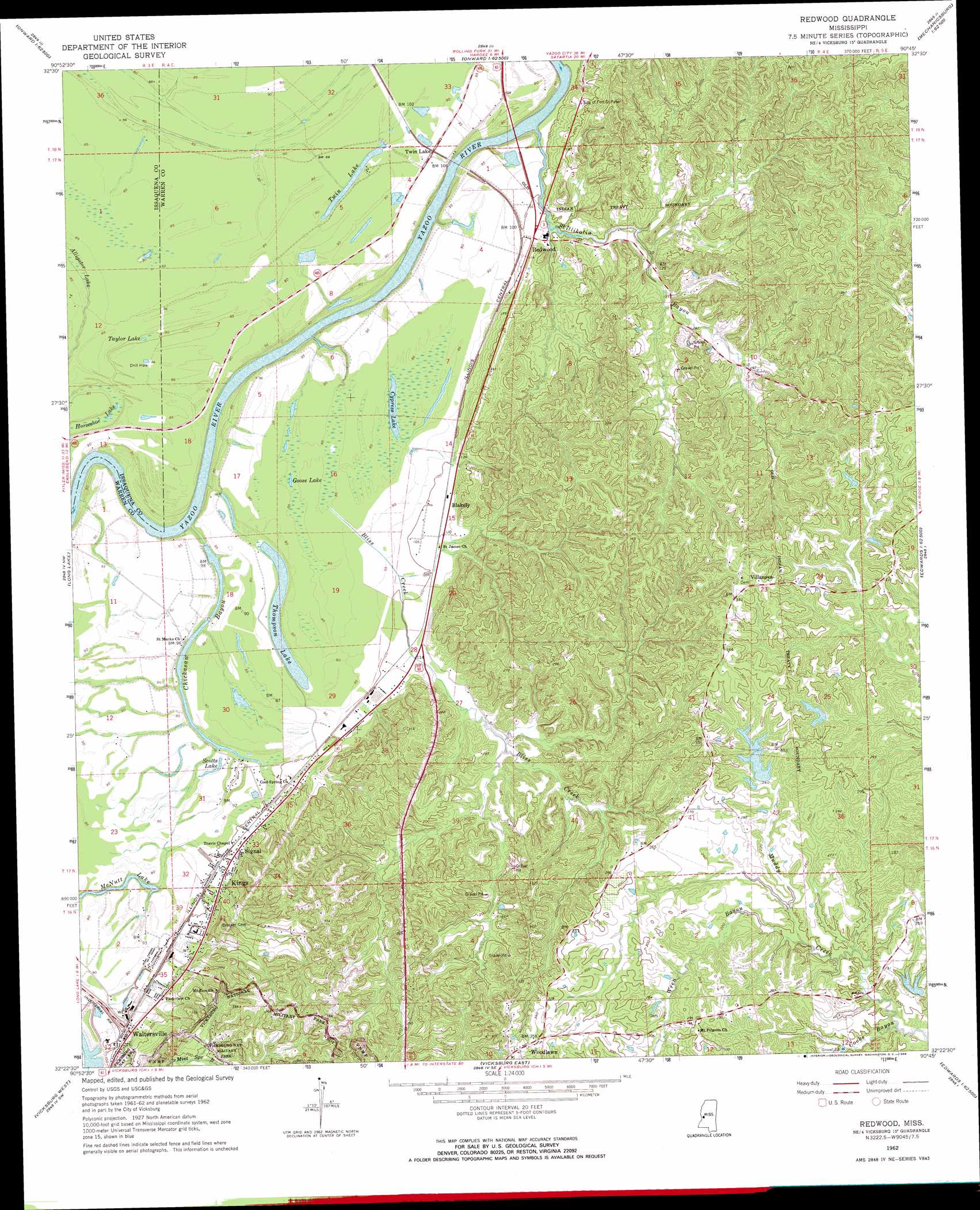
USGS Topo Quad 32090d7 - 1:24,000 scale
| Topo Map Name: | Redwood |
| USGS Topo Quad ID: | 32090d7 |
| Print Size: | ca. 21 1/4" wide x 27" high |
| Southeast Coordinates: | 32.375° N latitude / 90.75° W longitude |
| Map Center Coordinates: | 32.4375° N latitude / 90.8125° W longitude |
| U.S. State: | MS |
| Filename: | o32090d7.jpg |
| Download Map JPG Image: | Redwood topo map 1:24,000 scale |
| Map Type: | Topographic |
| Topo Series: | 7.5´ |
| Map Scale: | 1:24,000 |
| Source of Map Images: | United States Geological Survey (USGS) |
| Alternate Map Versions: |
Redwood MS 1962, updated 1963 Download PDF Buy paper map Redwood MS 1962, updated 1968 Download PDF Buy paper map Redwood MS 1962, updated 1968 Download PDF Buy paper map Redwood MS 2012 Download PDF Buy paper map Redwood MS 2015 Download PDF Buy paper map |
1:24,000 Topo Quads surrounding Redwood
Fitler |
Onward |
Valley Park |
Lucre |
Satartia |
Eagle Bend |
Cane Bayou |
Floweree |
Eldorado |
Phoenix |
Ashly |
Long Lake |
Redwood |
Oak Ridge |
Queens Hill Lake |
Mound |
Vicksburg West |
Vicksburg East |
Bovina |
Edwards |
Bedford |
Yokena |
Big Black |
Cayuga |
Learned |
> Back to 32090a1 at 1:100,000 scale
> Back to 32090a1 at 1:250,000 scale
> Back to U.S. Topo Maps home
Redwood topo map: Gazetteer
Redwood: Cliffs
Snyders Bluff elevation 47m 154′Redwood: Crossings
Redwood Ferry (historical) elevation 59m 193′Redwood: Dams
Chickasaw Bayou Dam elevation 28m 91′Choctaw Lake Dam elevation 83m 272′
Lake Forest Dam elevation 87m 285′
Openwood Plantation Lake Dam elevation 74m 242′
Openwood Plantation Lake Dam elevation 66m 216′
Southall Lake Dam elevation 87m 285′
Southall Lake Dam elevation 88m 288′
Southall Lake Dam elevation 86m 282′
Southall Lake Dam elevation 64m 209′
Thompson Lake Dam elevation 26m 85′
Redwood: Lakes
Goose Lake elevation 26m 85′Horseshoe Lake elevation 22m 72′
McNutt Lake elevation 24m 78′
Scotts Lake elevation 27m 88′
Taylor Lake elevation 24m 78′
Thompson Lake elevation 27m 88′
Twin Lake elevation 24m 78′
Redwood: Parks
Warren County Recreational Complex elevation 58m 190′Redwood: Populated Places
Blakely elevation 31m 101′Great Lake Estates elevation 92m 301′
Kings elevation 30m 98′
Lake Forest elevation 97m 318′
Openwood Plantation elevation 92m 301′
Redwood elevation 31m 101′
Signal elevation 31m 101′
Southall elevation 91m 298′
Twin Lake elevation 30m 98′
Valley Mills elevation 38m 124′
Villanova elevation 104m 341′
Waltersville elevation 38m 124′
Woodlawn elevation 110m 360′
Redwood: Ranges
Walnut Hills elevation 71m 232′Redwood: Springs
Cowans Spring elevation 59m 193′Redwood: Streams
Bliss Creek elevation 19m 62′Chickasaw Bayou elevation 18m 59′
Cooks Bayou elevation 49m 160′
Skillikalia Bayou elevation 22m 72′
Wren Bayou elevation 57m 187′
Redwood: Swamps
Alligator Lake elevation 23m 75′Redwood digital topo map on disk
Buy this Redwood topo map showing relief, roads, GPS coordinates and other geographical features, as a high-resolution digital map file on DVD: