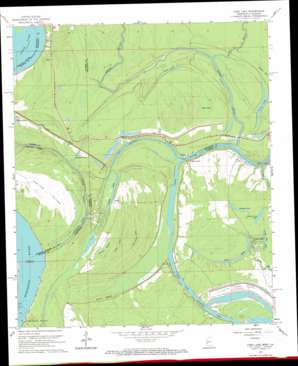
Long Lake Topo Map Mississippi
To zoom in, hover over the map of Long Lake
USGS Topo Quad 32090d8 - 1:24,000 scale
| Topo Map Name: | Long Lake |
| USGS Topo Quad ID: | 32090d8 |
| Print Size: | ca. 21 1/4" wide x 27" high |
| Southeast Coordinates: | 32.375° N latitude / 90.875° W longitude |
| Map Center Coordinates: | 32.4375° N latitude / 90.9375° W longitude |
| U.S. States: | MS, LA |
| Filename: | o32090d8.jpg |
| Download Map JPG Image: | Long Lake topo map 1:24,000 scale |
| Map Type: | Topographic |
| Topo Series: | 7.5´ |
| Map Scale: | 1:24,000 |
| Source of Map Images: | United States Geological Survey (USGS) |
| Alternate Map Versions: |
Long Lake MS 1962, updated 1963 Download PDF Buy paper map Long Lake MS 1962, updated 1969 Download PDF Buy paper map Long Lake MS 1962, updated 1969 Download PDF Buy paper map Long Lake MS 2012 Download PDF Buy paper map Long Lake MS 2015 Download PDF Buy paper map |
1:24,000 Topo Quads surrounding Long Lake
> Back to 32090a1 at 1:100,000 scale
> Back to 32090a1 at 1:250,000 scale
> Back to U.S. Topo Maps home
Long Lake topo map: Gazetteer
Long Lake: Canals
Yazoo River Diversion Canal elevation 15m 49′Long Lake: Channels
Old Channel elevation 18m 59′Long Lake: Crossings
Eagle Lake Ferry elevation 18m 59′Kings Ferry elevation 15m 49′
Sweets Ferry (historical) elevation 18m 59′
Long Lake: Guts
Boat Slough elevation 26m 85′Paw Paw Chute elevation 20m 65′
Willow Bayou elevation 25m 82′
Long Lake: Islands
Paw Paw Island elevation 30m 98′Long Lake: Lakes
Alligator Lake elevation 25m 82′Brecount Lake elevation 25m 82′
Duck Lake elevation 21m 68′
Eagle Lake elevation 23m 75′
Goose Lake elevation 18m 59′
Horseshoe Lake elevation 21m 68′
Indian Camp Lake elevation 24m 78′
Little Flat Lake elevation 24m 78′
Long Lake elevation 23m 75′
Moon Lake elevation 26m 85′
Taylor Lake elevation 19m 62′
Wallace Lake (historical) elevation 26m 85′
Long Lake: Populated Places
Long Lake elevation 27m 88′Long Lake: Streams
Cypress Bayou elevation 19m 62′False River (historical) elevation 17m 55′
Paw Paw Chute elevation 18m 59′
Steele Bayou elevation 18m 59′
Long Lake: Swamps
Fish Lake elevation 26m 85′Whteman Lake elevation 25m 82′
Willow Bayou elevation 26m 85′
Wilton Bayou elevation 24m 78′
Long Lake digital topo map on disk
Buy this Long Lake topo map showing relief, roads, GPS coordinates and other geographical features, as a high-resolution digital map file on DVD:


