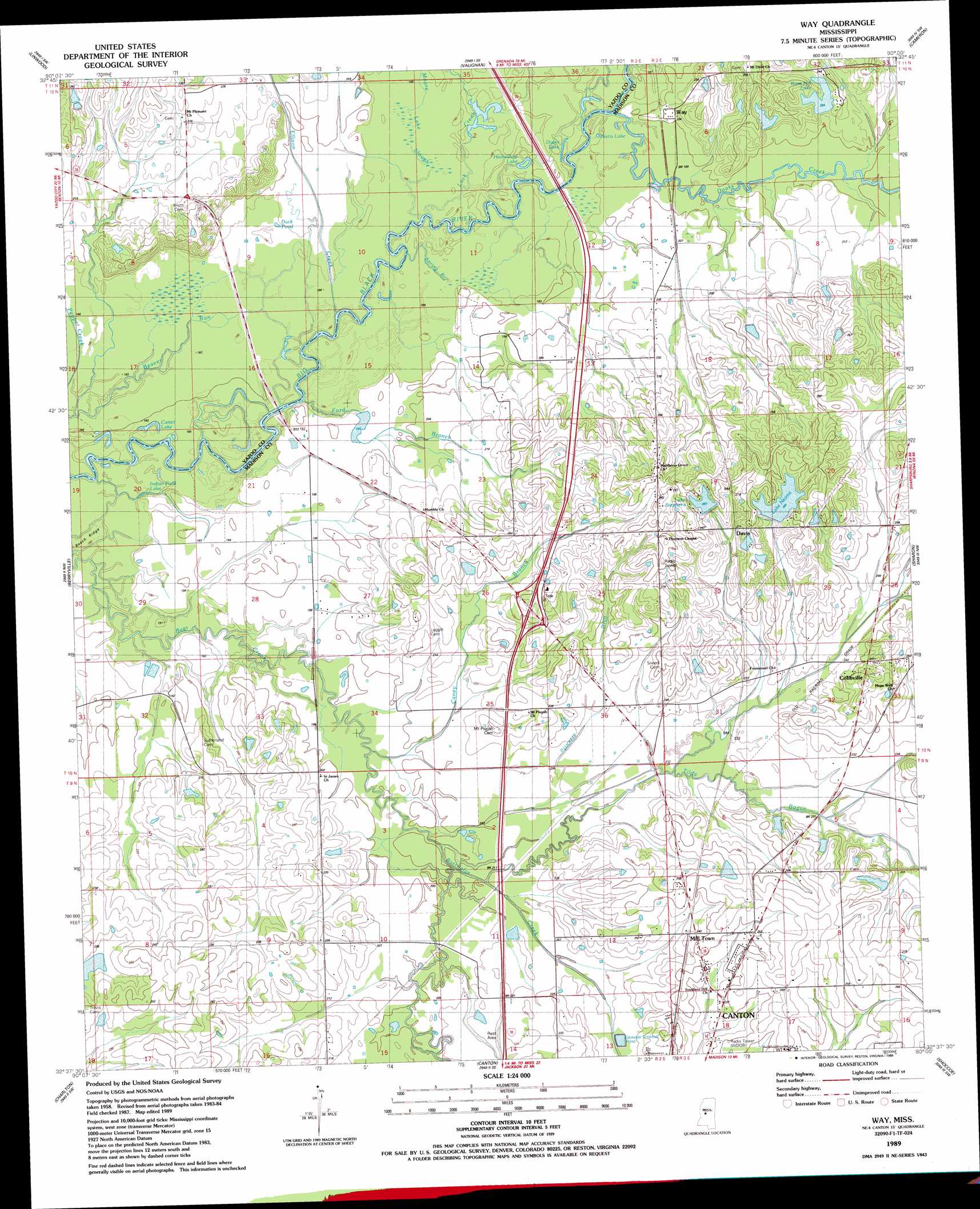
Way Topo Map Mississippi
To zoom in, hover over the map of Way
USGS Topo Quad 32090f1 - 1:24,000 scale
| Topo Map Name: | Way |
| USGS Topo Quad ID: | 32090f1 |
| Print Size: | ca. 21 1/4" wide x 27" high |
| Southeast Coordinates: | 32.625° N latitude / 90° W longitude |
| Map Center Coordinates: | 32.6875° N latitude / 90.0625° W longitude |
| U.S. State: | MS |
| Filename: | o32090f1.jpg |
| Download Map JPG Image: | Way topo map 1:24,000 scale |
| Map Type: | Topographic |
| Topo Series: | 7.5´ |
| Map Scale: | 1:24,000 |
| Source of Map Images: | United States Geological Survey (USGS) |
| Alternate Map Versions: |
Way MS 1989, updated 1989 Download PDF Buy paper map Way MS 2012 Download PDF Buy paper map Way MS 2015 Download PDF Buy paper map |
1:24,000 Topo Quads surrounding Way
Eden |
Zeiglerville |
Ebenezer |
Goodman |
Newport |
Benton |
Linwood |
Vaughan |
Cameron |
Camden |
Bentonia |
Berryville |
Way |
Sharon |
Farmhaven |
Flora |
Charlton |
Canton |
Shoccoe |
Sharon Se |
Pocahontas |
Ridgeland |
Madison |
Goshen Springs |
Leesburg |
> Back to 32090e1 at 1:100,000 scale
> Back to 32090a1 at 1:250,000 scale
> Back to U.S. Topo Maps home
Way topo map: Gazetteer
Way: Canals
Luckett Ditch elevation 67m 219′Way: Crossings
Interchange 124 elevation 79m 259′Way: Dams
A N Holiday Lake Dam elevation 67m 219′B H Cooper Lake Dam elevation 87m 285′
Bob Ray Lake Dam elevation 72m 236′
Charvers Lake Dam elevation 58m 190′
Clyde Edwards Lake Dam elevation 79m 259′
D C Suther Lake Dam elevation 65m 213′
D P Murphy Lake Dam elevation 55m 180′
Henry Brown Lake Dam elevation 72m 236′
Lake Neoma Dam elevation 85m 278′
Mason Catfish Ponds Dam elevation 64m 209′
W J Sumrall Lake Dam elevation 70m 229′
Way: Lakes
Carter Lake elevation 55m 180′Dixon Lake elevation 57m 187′
Duck Pond elevation 58m 190′
Goose Pond elevation 57m 187′
Horseshoe Lake elevation 56m 183′
Indian Field Lake elevation 55m 180′
Long Lake elevation 57m 187′
Walker Lake elevation 55m 180′
Watts Lake elevation 58m 190′
Way: Populated Places
Cobbville elevation 89m 291′Davis elevation 90m 295′
Mill Town elevation 75m 246′
Milltown elevation 77m 252′
Way elevation 64m 209′
Way: Reservoirs
Lake Neoma elevation 87m 285′Lake Stephens elevation 87m 285′
Rose Hill Lake elevation 67m 219′
Way: Ridges
Beech Ridge elevation 57m 187′Way: Streams
Batchelor Creek elevation 58m 190′Beaver Run elevation 55m 180′
Caney Branch elevation 58m 190′
Doaks Creek elevation 57m 187′
Ellison Creek elevation 55m 180′
Ford Branch elevation 55m 180′
Lock Creek elevation 57m 187′
Moore Lake Slough elevation 57m 187′
Spring Branch elevation 57m 187′
Tilda Bogue elevation 62m 203′
Way digital topo map on disk
Buy this Way topo map showing relief, roads, GPS coordinates and other geographical features, as a high-resolution digital map file on DVD: