Linwood Topo Map Mississippi
To zoom in, hover over the map of Linwood
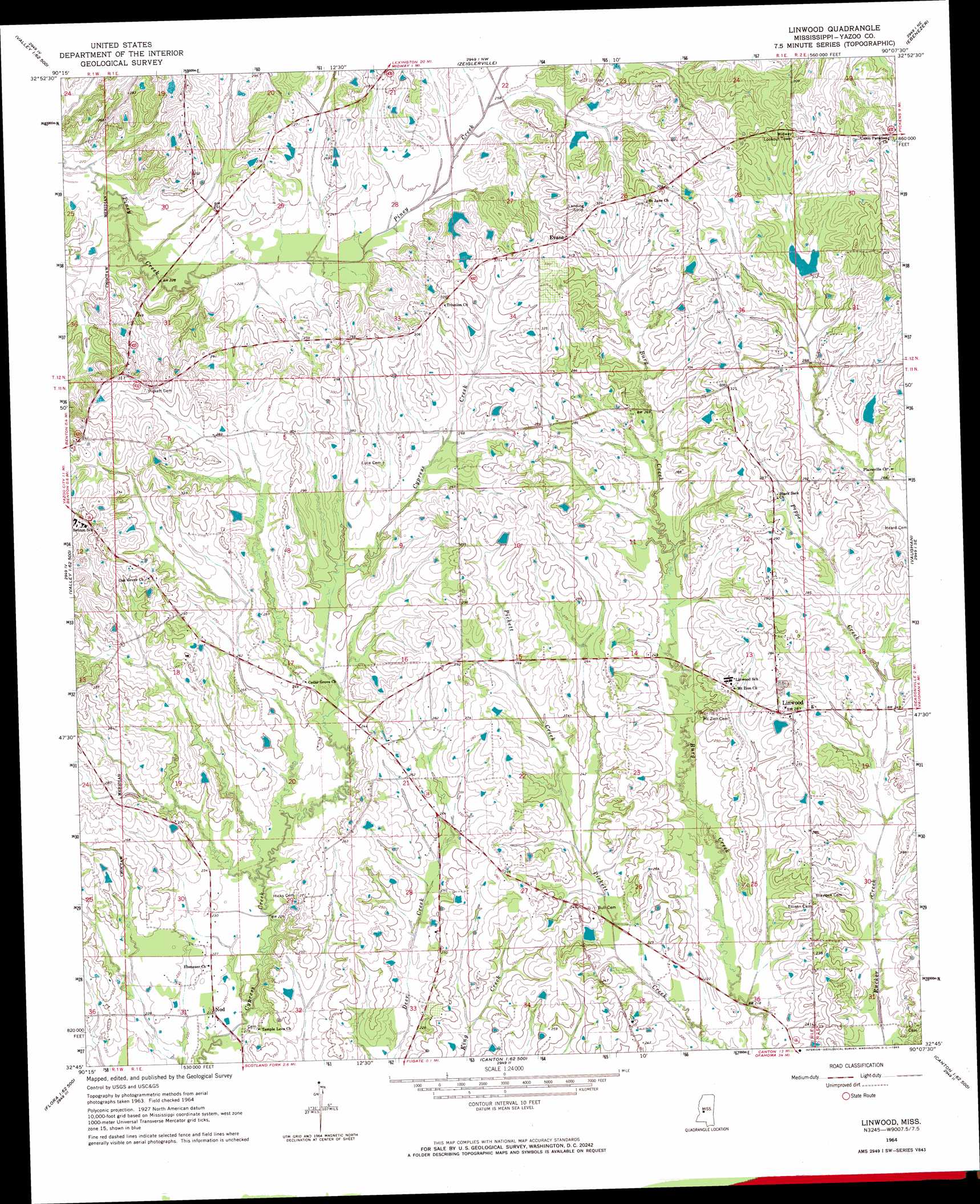
USGS Topo Quad 32090g2 - 1:24,000 scale
| Topo Map Name: | Linwood |
| USGS Topo Quad ID: | 32090g2 |
| Print Size: | ca. 21 1/4" wide x 27" high |
| Southeast Coordinates: | 32.75° N latitude / 90.125° W longitude |
| Map Center Coordinates: | 32.8125° N latitude / 90.1875° W longitude |
| U.S. State: | MS |
| Filename: | o32090g2.jpg |
| Download Map JPG Image: | Linwood topo map 1:24,000 scale |
| Map Type: | Topographic |
| Topo Series: | 7.5´ |
| Map Scale: | 1:24,000 |
| Source of Map Images: | United States Geological Survey (USGS) |
| Alternate Map Versions: |
Linwood MS 1964, updated 1965 Download PDF Buy paper map Linwood MS 1964, updated 1982 Download PDF Buy paper map Linwood MS 2012 Download PDF Buy paper map Linwood MS 2015 Download PDF Buy paper map |
1:24,000 Topo Quads surrounding Linwood
Silver City |
Thornton |
Howard |
Lexington South |
Owens Wells |
Carter |
Eden |
Zeiglerville |
Ebenezer |
Goodman |
Yazoo City |
Benton |
Linwood |
Vaughan |
Cameron |
Tinsley |
Bentonia |
Berryville |
Way |
Sharon |
Coxs Ferry |
Flora |
Charlton |
Canton |
Shoccoe |
> Back to 32090e1 at 1:100,000 scale
> Back to 32090a1 at 1:250,000 scale
> Back to U.S. Topo Maps home
Linwood topo map: Gazetteer
Linwood: Airports
Linwood Airport elevation 83m 272′Linwood: Dams
Campbell Lake Dam elevation 94m 308′Ellison Creek Watershed 1 Dam elevation 86m 282′
Ellison Creek Watershed Structure 4 Dam elevation 82m 269′
Hearst Lake Dam elevation 82m 269′
Hearst Lake Dam elevation 94m 308′
Swayze Lake Dam elevation 98m 321′
Williams Estate Pond Dam elevation 80m 262′
Linwood: Populated Places
Evans elevation 98m 321′Linwood elevation 85m 278′
Nod elevation 67m 219′
Linwood: Streams
Pepper Creek elevation 69m 226′Linwood digital topo map on disk
Buy this Linwood topo map showing relief, roads, GPS coordinates and other geographical features, as a high-resolution digital map file on DVD: