Grand Gulf Topo Map Mississippi
To zoom in, hover over the map of Grand Gulf
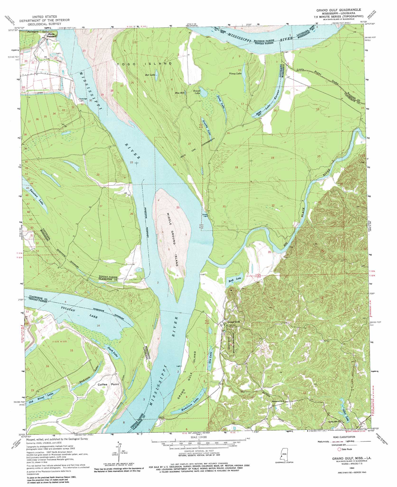
USGS Topo Quad 32091a1 - 1:24,000 scale
| Topo Map Name: | Grand Gulf |
| USGS Topo Quad ID: | 32091a1 |
| Print Size: | ca. 21 1/4" wide x 27" high |
| Southeast Coordinates: | 32° N latitude / 91° W longitude |
| Map Center Coordinates: | 32.0625° N latitude / 91.0625° W longitude |
| U.S. States: | MS, LA |
| Filename: | o32091a1.jpg |
| Download Map JPG Image: | Grand Gulf topo map 1:24,000 scale |
| Map Type: | Topographic |
| Topo Series: | 7.5´ |
| Map Scale: | 1:24,000 |
| Source of Map Images: | United States Geological Survey (USGS) |
| Alternate Map Versions: |
Grand Gulf MS 1963, updated 1964 Download PDF Buy paper map Grand Gulf MS 1963, updated 1973 Download PDF Buy paper map Grand Gulf MS 1963, updated 1984 Download PDF Buy paper map Grand Gulf MS 2012 Download PDF Buy paper map Grand Gulf MS 2015 Download PDF Buy paper map |
1:24,000 Topo Quads surrounding Grand Gulf
Waverly Se |
Fortune Fork |
Mound |
Vicksburg West |
Vicksburg East |
Westwood |
Somerset |
Bedford |
Yokena |
Big Black |
Saranac |
Newellton |
Grand Gulf |
Willows |
Carlisle |
Lake Bruin |
Saint Joseph |
Widows Creek |
Port Gibson |
Hermanville |
Chamblee |
Rodney |
Lorman |
Red Lick |
Mcbride |
> Back to 32091a1 at 1:100,000 scale
> Back to 32090a1 at 1:250,000 scale
> Back to U.S. Topo Maps home
Grand Gulf topo map: Gazetteer
Grand Gulf: Areas
Grand Gulf Island elevation 22m 72′Grand Gulf: Bends
Grand Gulf Bend elevation 10m 32′Newtown Bend elevation 12m 39′
Grand Gulf: Canals
Yucatan Ditch elevation 14m 45′Grand Gulf: Capes
Coffee Point elevation 25m 82′Coffeys Point elevation 34m 111′
Point Pleasant elevation 25m 82′
Grand Gulf: Channels
Yucatan Cutoff elevation 12m 39′Grand Gulf: Cliffs
Thompsons Bluff elevation 30m 98′Grand Gulf: Crossings
McKay Ferry (historical) elevation 16m 52′Grand Gulf: Dams
Allen Lake Dam elevation 38m 124′Grand Gulf: Islands
Middle Ground Island elevation 19m 62′Togo Island elevation 24m 78′
Grand Gulf: Lakes
Bar Lake elevation 19m 62′Blue Hole elevation 24m 78′
Brushy Lake elevation 19m 62′
Dishroon Lake elevation 20m 65′
Duck Lake elevation 14m 45′
Gin Lake elevation 16m 52′
Hamilton Lake elevation 16m 52′
Lake Karnac elevation 18m 59′
Lake Karnac elevation 18m 59′
Long Lake elevation 18m 59′
Rock Lake elevation 15m 49′
Round Lake elevation 18m 59′
Viney Lake elevation 19m 62′
Grand Gulf: Levees
Lake Karnac Revetment elevation 18m 59′Grand Gulf: Parks
Grand Gulf Military Monument elevation 64m 209′Grand Gulf: Populated Places
Allen elevation 52m 170′Grand Gulf elevation 29m 95′
Grand Gulf: Reservoirs
Allen Lake elevation 37m 121′Grand Gulf: Streams
Big Black River elevation 13m 42′Grand Gulf digital topo map on disk
Buy this Grand Gulf topo map showing relief, roads, GPS coordinates and other geographical features, as a high-resolution digital map file on DVD: