Sondheimer Topo Map Louisiana
To zoom in, hover over the map of Sondheimer
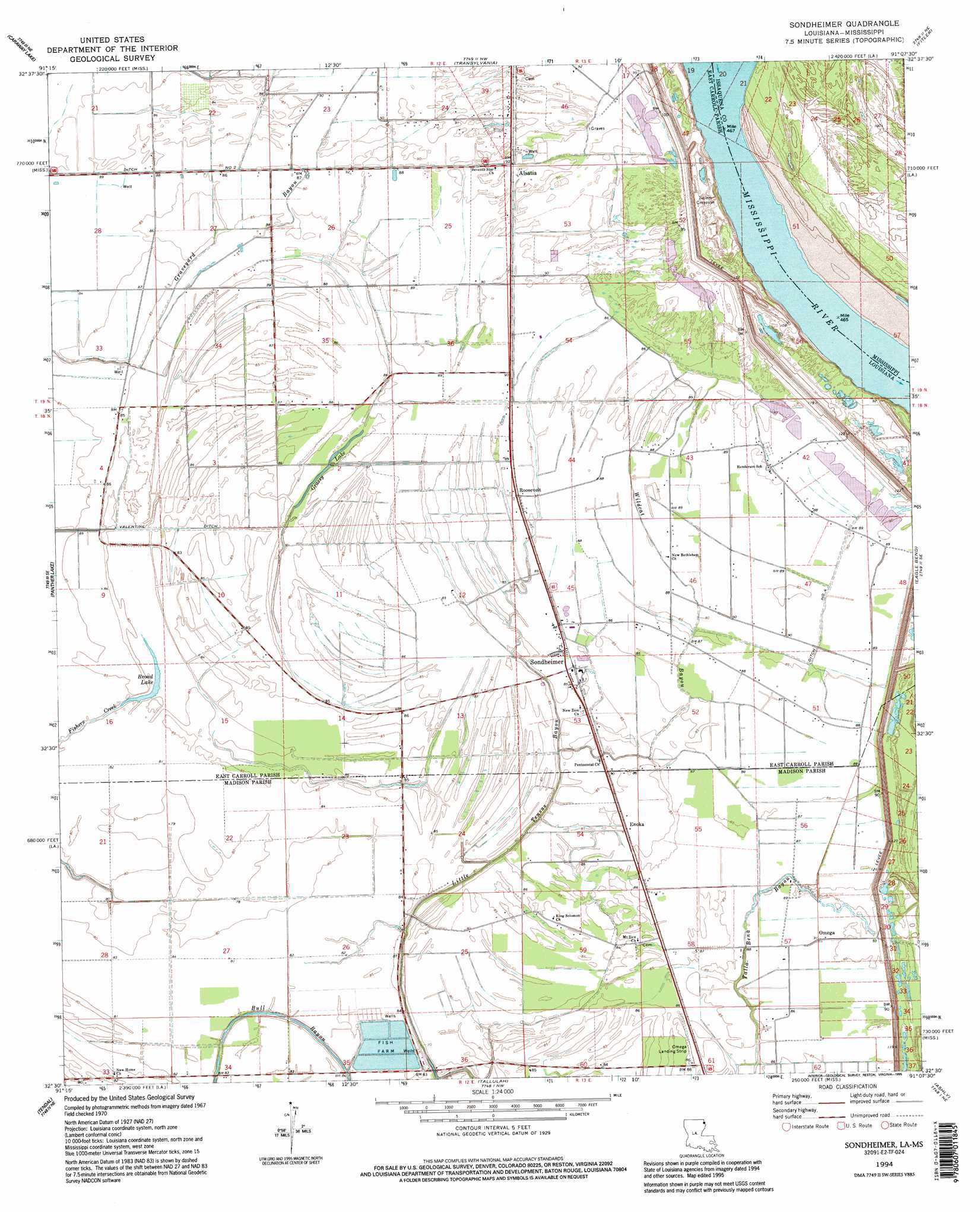
USGS Topo Quad 32091e2 - 1:24,000 scale
| Topo Map Name: | Sondheimer |
| USGS Topo Quad ID: | 32091e2 |
| Print Size: | ca. 21 1/4" wide x 27" high |
| Southeast Coordinates: | 32.5° N latitude / 91.125° W longitude |
| Map Center Coordinates: | 32.5625° N latitude / 91.1875° W longitude |
| U.S. States: | LA, MS |
| Filename: | o32091e2.jpg |
| Download Map JPG Image: | Sondheimer topo map 1:24,000 scale |
| Map Type: | Topographic |
| Topo Series: | 7.5´ |
| Map Scale: | 1:24,000 |
| Source of Map Images: | United States Geological Survey (USGS) |
| Alternate Map Versions: |
Sondheimer LA 1970, updated 1972 Download PDF Buy paper map Sondheimer LA 1994, updated 1995 Download PDF Buy paper map Sondheimer LA 2012 Download PDF Buy paper map Sondheimer LA 2015 Download PDF Buy paper map |
1:24,000 Topo Quads surrounding Sondheimer
Oak Grove |
Baxter Bayou |
Lake Providence |
Whiting Bayou |
Cary |
Pioneer |
Caraway Lake |
Transylvania |
Fitler |
Onward |
Epps |
Panther Lake |
Sondheimer |
Eagle Bend |
Cane Bayou |
Africa Lake |
Tendal |
Tallulah |
Ashly |
Long Lake |
Indian Lake |
Waverly Se |
Fortune Fork |
Mound |
Vicksburg West |
> Back to 32091e1 at 1:100,000 scale
> Back to 32090a1 at 1:250,000 scale
> Back to U.S. Topo Maps home
Sondheimer topo map: Gazetteer
Sondheimer: Airports
Omega Landing Strip elevation 26m 85′Sondheimer: Basins
Salem Crevasse elevation 26m 85′Sondheimer: Canals
Ditch Number Two elevation 25m 82′Sondheimer: Guts
Fishers Creek elevation 24m 78′Wildcat Bayou elevation 26m 85′
Sondheimer: Lakes
Broad Lake elevation 23m 75′Grassy Lake elevation 24m 78′
Sondheimer: Levees
Goodrich Revetment elevation 27m 88′Sondheimer: Populated Places
Alsatia elevation 26m 85′Bomer elevation 27m 88′
Enoka elevation 24m 78′
Omega elevation 27m 88′
Roosevelt elevation 27m 88′
Sondheimer elevation 26m 85′
Stamboul (historical) elevation 28m 91′
Sondheimer: Post Offices
Sondheimer Post Office (historical) elevation 26m 85′Sondheimer: Streams
Bull Bayou elevation 22m 72′Little Tensas Bayou elevation 26m 85′
Sondheimer digital topo map on disk
Buy this Sondheimer topo map showing relief, roads, GPS coordinates and other geographical features, as a high-resolution digital map file on DVD: