Danville Topo Map Louisiana
To zoom in, hover over the map of Danville
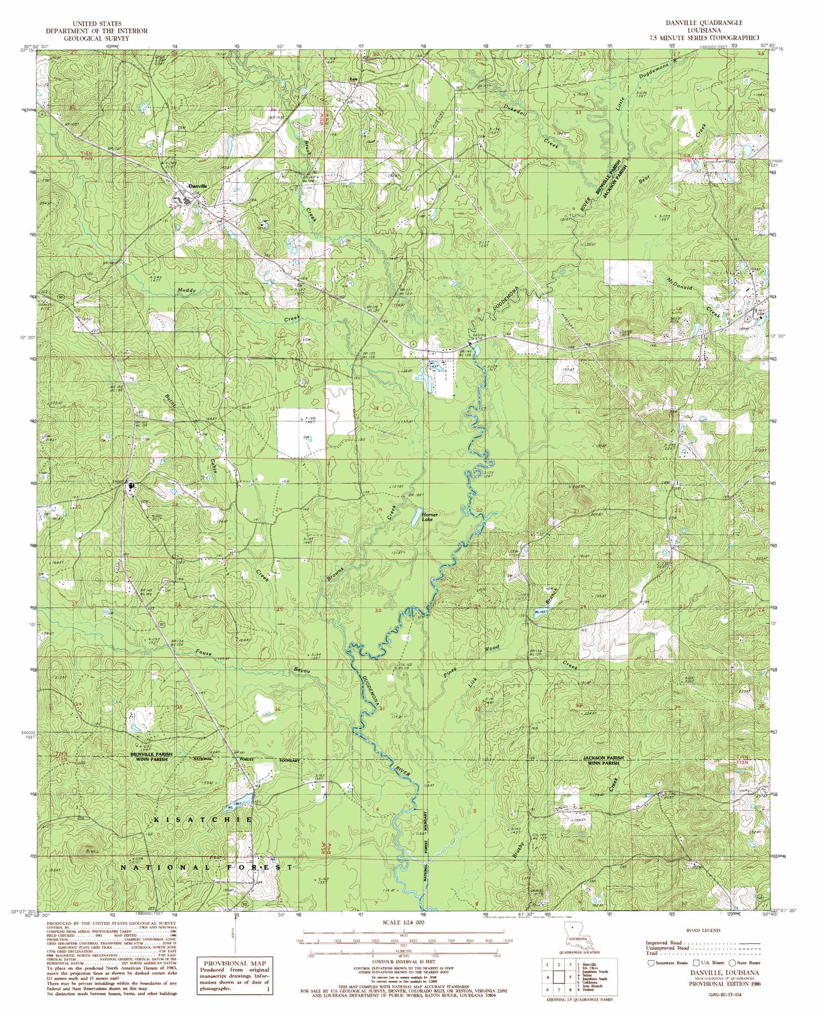
USGS Topo Quad 32092b7 - 1:24,000 scale
| Topo Map Name: | Danville |
| USGS Topo Quad ID: | 32092b7 |
| Print Size: | ca. 21 1/4" wide x 27" high |
| Southeast Coordinates: | 32.125° N latitude / 92.75° W longitude |
| Map Center Coordinates: | 32.1875° N latitude / 92.8125° W longitude |
| U.S. State: | LA |
| Filename: | o32092b7.jpg |
| Download Map JPG Image: | Danville topo map 1:24,000 scale |
| Map Type: | Topographic |
| Topo Series: | 7.5´ |
| Map Scale: | 1:24,000 |
| Source of Map Images: | United States Geological Survey (USGS) |
| Alternate Map Versions: |
Danville LA 1986, updated 1986 Download PDF Buy paper map Danville LA 2003, updated 2005 Download PDF Buy paper map Danville LA 2012 Download PDF Buy paper map Danville LA 2015 Download PDF Buy paper map |
| FStopo: | US Forest Service topo Danville is available: Download FStopo PDF Download FStopo TIF |
1:24,000 Topo Quads surrounding Danville
Sailes |
Bryceland |
Wilson Creek |
Clay |
Vernon |
Sparta |
Bienville |
Mount Olive |
Jonesboro North |
Curr Creek |
Ashland |
Saline |
Danville |
Jonesboro South |
Weston |
Chestnut |
Goldonna |
Iron Branch |
Dodson |
Hudson |
Campti |
Coup Point |
Calvin |
Winnfield West |
Winnfield East |
> Back to 32092a1 at 1:100,000 scale
> Back to 32092a1 at 1:250,000 scale
> Back to U.S. Topo Maps home
Danville topo map: Gazetteer
Danville: Lakes
Horner Lake elevation 36m 118′Danville: Oilfields
Danville Gas Field elevation 62m 203′Danville: Populated Places
Danville elevation 61m 200′Evergreen elevation 65m 213′
Loe elevation 65m 213′
Shady elevation 64m 209′
Danville: Post Offices
Danville Post Office (historical) elevation 51m 167′Danville: Streams
Bear Creek elevation 40m 131′Boggy Creek elevation 36m 118′
Browns Creek elevation 37m 121′
Brush Creek elevation 38m 124′
Brushy Creek elevation 35m 114′
Burnt Cabin Creek elevation 36m 118′
Dukedall Creek elevation 40m 131′
Fouse Bayou elevation 35m 114′
Little Dugdemona River elevation 40m 131′
McDonald Creek elevation 39m 127′
Muddy Creek elevation 38m 124′
Piney Wood Branch elevation 36m 118′
Danville digital topo map on disk
Buy this Danville topo map showing relief, roads, GPS coordinates and other geographical features, as a high-resolution digital map file on DVD: