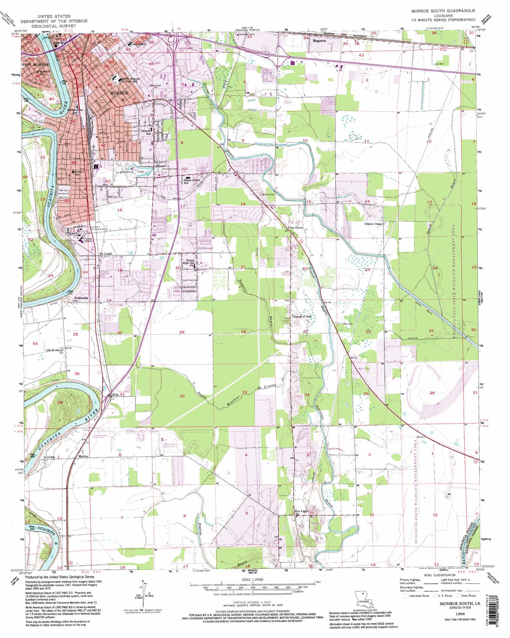
Monroe South Topo Map Louisiana
To zoom in, hover over the map of Monroe South
USGS Topo Quad 32092d1 - 1:24,000 scale
| Topo Map Name: | Monroe South |
| USGS Topo Quad ID: | 32092d1 |
| Print Size: | ca. 21 1/4" wide x 27" high |
| Southeast Coordinates: | 32.375° N latitude / 92° W longitude |
| Map Center Coordinates: | 32.4375° N latitude / 92.0625° W longitude |
| U.S. State: | LA |
| Filename: | o32092d1.jpg |
| Download Map JPG Image: | Monroe South topo map 1:24,000 scale |
| Map Type: | Topographic |
| Topo Series: | 7.5´ |
| Map Scale: | 1:24,000 |
| Source of Map Images: | United States Geological Survey (USGS) |
| Alternate Map Versions: |
Monroe South LA 1957, updated 1958 Download PDF Buy paper map Monroe South LA 1957, updated 1967 Download PDF Buy paper map Monroe South LA 1957, updated 1969 Download PDF Buy paper map Monroe South LA 1957, updated 1975 Download PDF Buy paper map Monroe South LA 1957, updated 1986 Download PDF Buy paper map Monroe South LA 1994, updated 1995 Download PDF Buy paper map Monroe South LA 1999, updated 2000 Download PDF Buy paper map Monroe South LA 2012 Download PDF Buy paper map Monroe South LA 2015 Download PDF Buy paper map |
1:24,000 Topo Quads surrounding Monroe South
Point |
Rocky Branch |
Sterlington |
Collinston West |
Collinston East |
Calhoun |
West Monroe North |
Monroe North |
Swartz |
Irwin Lake |
Cadeville |
West Monroe South |
Monroe South |
Crew Lake |
Rayville |
Chatham Se |
Luna |
Bosco |
Gilleyville |
Mangham |
Vixen |
Blankston |
Riverton |
Hebert |
Liddieville |
> Back to 32092a1 at 1:100,000 scale
> Back to 32092a1 at 1:250,000 scale
> Back to U.S. Topo Maps home
Monroe South topo map: Gazetteer
Monroe South: Airports
E A Conway Hospital Heliport elevation 24m 78′Willow Wind Landing Strip elevation 20m 65′
Monroe South: Areas
Prairie Du Bois elevation 21m 68′Monroe South: Canals
Pine Bayou Canal elevation 19m 62′Monroe South: Crossings
Interchange 116B elevation 23m 75′Interchange 118 elevation 20m 65′
Interchange 120 elevation 22m 72′
Monroe South: Dams
Lock and Dam Number Four (historical) elevation 17m 55′Monroe South: Oilfields
Petticoat Bayou Gas Field elevation 18m 59′Monroe South: Parks
Benoit Recreation Area elevation 20m 65′Bernstein Park elevation 21m 68′
Downtown Monroe Historic District elevation 24m 78′
Lazarres Recreation Area elevation 20m 65′
Louisiana Purchase Gardens elevation 21m 68′
Robinson Place Park elevation 21m 68′
Monroe South: Populated Places
Charmingdale elevation 20m 65′Cobb elevation 22m 72′
De Loach elevation 23m 75′
East Parkview elevation 20m 65′
Erco elevation 21m 68′
Forest Oaks elevation 20m 65′
Garden Park elevation 21m 68′
Green Terrace elevation 21m 68′
Huntington Park elevation 20m 65′
Kings Oaks elevation 21m 68′
Lincoln Park elevation 22m 72′
Magenta elevation 22m 72′
Maidco elevation 21m 68′
Pine Grove elevation 21m 68′
Pino Bayou Village elevation 21m 68′
Richwood elevation 22m 72′
Rilla elevation 21m 68′
Robinson Place elevation 22m 72′
Southwinds elevation 20m 65′
Tanglewood elevation 20m 65′
Monroe South: Streams
Bayou Mouchoir De L'Ourse elevation 17m 55′Gourd Bayou elevation 18m 59′
Raccoon Bayou elevation 17m 55′
Youngs Bayou elevation 18m 59′
Monroe South digital topo map on disk
Buy this Monroe South topo map showing relief, roads, GPS coordinates and other geographical features, as a high-resolution digital map file on DVD: