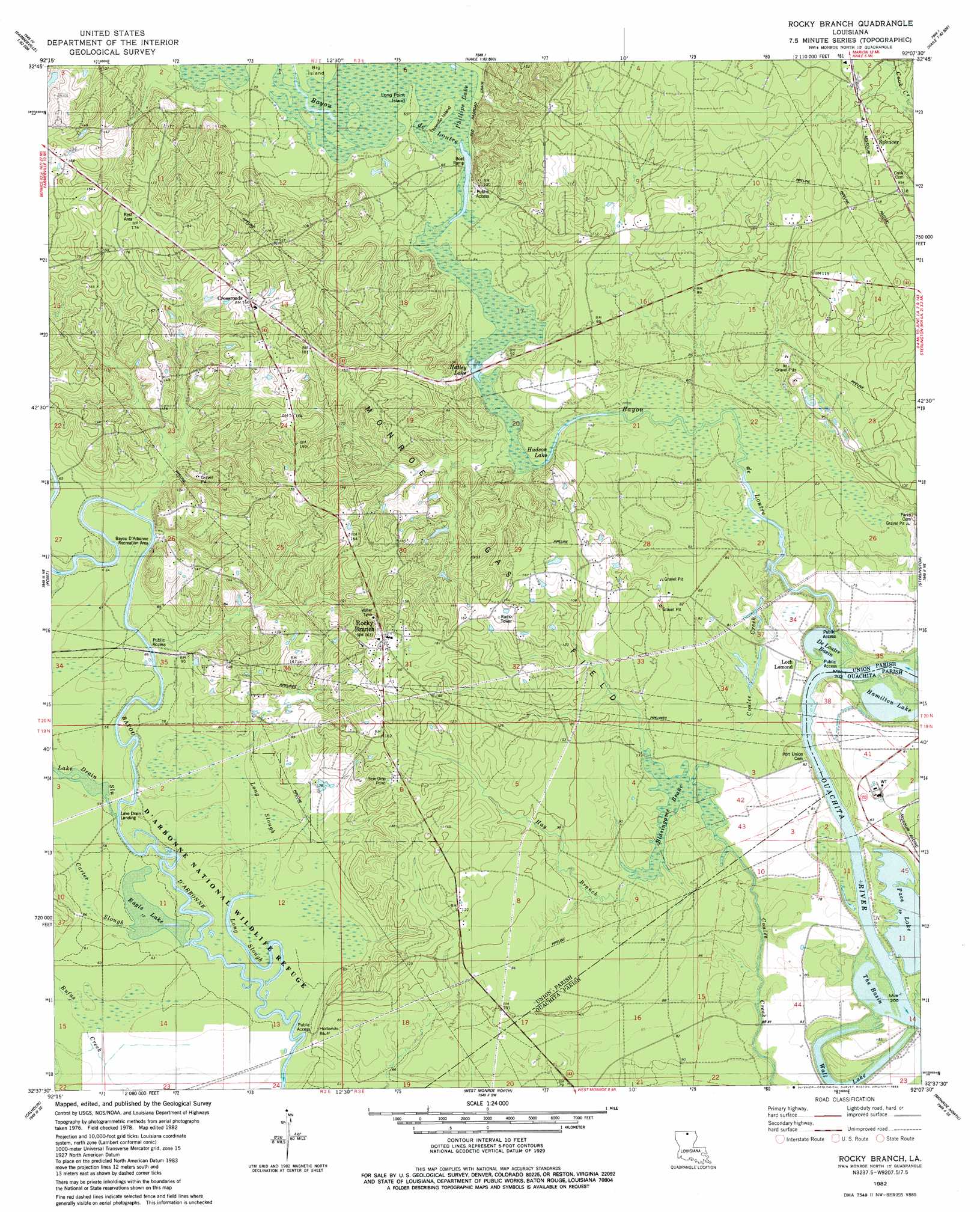
Rocky Branch Topo Map Louisiana
To zoom in, hover over the map of Rocky Branch
USGS Topo Quad 32092f2 - 1:24,000 scale
| Topo Map Name: | Rocky Branch |
| USGS Topo Quad ID: | 32092f2 |
| Print Size: | ca. 21 1/4" wide x 27" high |
| Southeast Coordinates: | 32.625° N latitude / 92.125° W longitude |
| Map Center Coordinates: | 32.6875° N latitude / 92.1875° W longitude |
| U.S. State: | LA |
| Filename: | o32092f2.jpg |
| Download Map JPG Image: | Rocky Branch topo map 1:24,000 scale |
| Map Type: | Topographic |
| Topo Series: | 7.5´ |
| Map Scale: | 1:24,000 |
| Source of Map Images: | United States Geological Survey (USGS) |
| Alternate Map Versions: |
Rocky Branch LA 1982, updated 1983 Download PDF Buy paper map Rocky Branch LA 2012 Download PDF Buy paper map Rocky Branch LA 2015 Download PDF Buy paper map |
1:24,000 Topo Quads surrounding Rocky Branch
Truxno |
Marion West |
Marion East |
Fish Lake |
Beckman |
Farmerville |
De Loutre |
Haille |
Harrell Lake |
Bastrop |
Downsville North |
Point |
Rocky Branch |
Sterlington |
Collinston West |
Downsville South |
Calhoun |
West Monroe North |
Monroe North |
Swartz |
Eros |
Cadeville |
West Monroe South |
Monroe South |
Crew Lake |
> Back to 32092e1 at 1:100,000 scale
> Back to 32092a1 at 1:250,000 scale
> Back to U.S. Topo Maps home
Rocky Branch topo map: Gazetteer
Rocky Branch: Basins
De Loutre Basin elevation 18m 59′The Basin elevation 18m 59′
Rocky Branch: Cliffs
Hollands Bluff elevation 26m 85′Rocky Branch: Crossings
Phillips Ferry elevation 20m 65′Rocky Branch: Guts
Long Slough elevation 18m 59′Rocky Branch: Islands
Big Island elevation 20m 65′Long Point Island elevation 20m 65′
Tenmile Island elevation 19m 62′
Rocky Branch: Lakes
Eagle Lake elevation 18m 59′Hamilton Lake elevation 18m 59′
Hatley Lake elevation 19m 62′
Henderson Lake elevation 18m 59′
Pace Lake elevation 18m 59′
Phillips Lake elevation 19m 62′
Wall Lake elevation 18m 59′
Rocky Branch: Parks
Bayou D'Arbonne Recreation Area elevation 21m 68′Rocky Branch: Populated Places
Colsons (historical) elevation 46m 150′Crossroads elevation 52m 170′
Loch Lomond elevation 25m 82′
Port Union (historical) elevation 24m 78′
Rocky Branch elevation 48m 157′
Spencer elevation 37m 121′
Wall Lake elevation 25m 82′
Rocky Branch: Post Offices
Spencer Post Office elevation 37m 121′Rocky Branch: Streams
Bayou de Loutre elevation 18m 59′Carter Slough elevation 18m 59′
Coulee Creek elevation 18m 59′
Coulee Creek elevation 20m 65′
Hay Branch elevation 22m 72′
Lake Drain Slough elevation 18m 59′
Rufus Creek elevation 18m 59′
Rocky Branch: Swamps
Blasingame Brake elevation 21m 68′Rocky Branch digital topo map on disk
Buy this Rocky Branch topo map showing relief, roads, GPS coordinates and other geographical features, as a high-resolution digital map file on DVD: