Fish Lake Topo Map Louisiana
To zoom in, hover over the map of Fish Lake
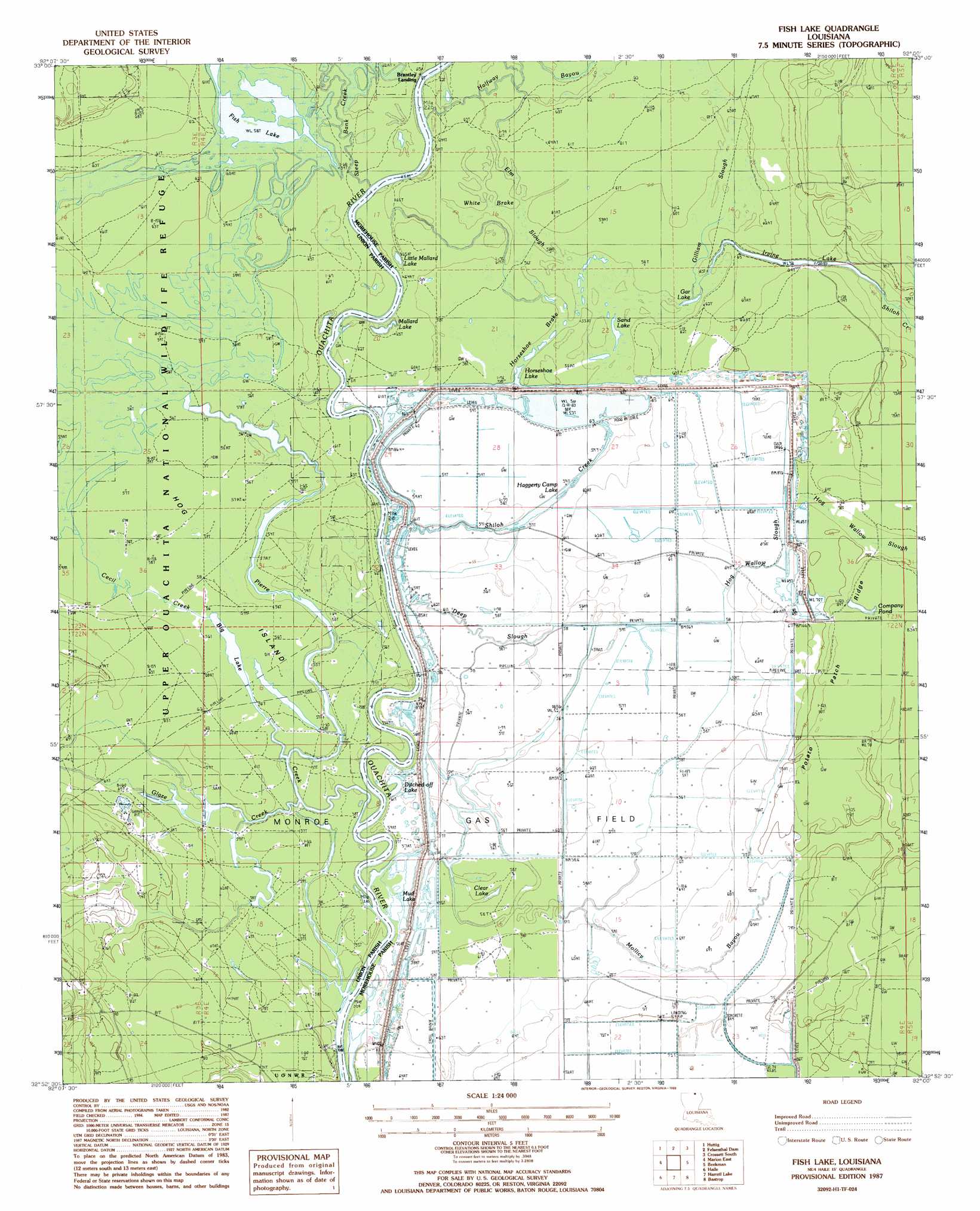
USGS Topo Quad 32092h1 - 1:24,000 scale
| Topo Map Name: | Fish Lake |
| USGS Topo Quad ID: | 32092h1 |
| Print Size: | ca. 21 1/4" wide x 27" high |
| Southeast Coordinates: | 32.875° N latitude / 92° W longitude |
| Map Center Coordinates: | 32.9375° N latitude / 92.0625° W longitude |
| U.S. State: | LA |
| Filename: | o32092h1.jpg |
| Download Map JPG Image: | Fish Lake topo map 1:24,000 scale |
| Map Type: | Topographic |
| Topo Series: | 7.5´ |
| Map Scale: | 1:24,000 |
| Source of Map Images: | United States Geological Survey (USGS) |
| Alternate Map Versions: |
Fish Lake LA 1987, updated 1988 Download PDF Buy paper map Fish Lake LA 2012 Download PDF Buy paper map Fish Lake LA 2015 Download PDF Buy paper map |
1:24,000 Topo Quads surrounding Fish Lake
New London |
New Union |
Marais Saline |
Crossett North |
Hamburg |
Strong |
Huttig |
Felsenthal Dam |
Crossett South |
Berlin |
Marion West |
Marion East |
Fish Lake |
Beckman |
Twin Oaks |
De Loutre |
Haille |
Harrell Lake |
Bastrop |
Mer Rouge |
Point |
Rocky Branch |
Sterlington |
Collinston West |
Collinston East |
> Back to 32092e1 at 1:100,000 scale
> Back to 32092a1 at 1:250,000 scale
> Back to U.S. Topo Maps home
Fish Lake topo map: Gazetteer
Fish Lake: Channels
Irwin Reach elevation 16m 52′Fish Lake: Guts
Elm Slough elevation 18m 59′Fish Lake: Islands
Hog Island elevation 17m 55′Fish Lake: Lakes
Big Lake elevation 17m 55′Clear Lake elevation 17m 55′
Ditched-off Lake elevation 17m 55′
Fish Lake elevation 17m 55′
Gar Lake elevation 17m 55′
Haggerty Camp Lake elevation 17m 55′
Horseshoe Lake elevation 17m 55′
Irvine Lake elevation 18m 59′
Little Mallard Lake elevation 18m 59′
Mallard Lake elevation 17m 55′
Mud Lake elevation 16m 52′
Sand Lake elevation 17m 55′
Fish Lake: Populated Places
Brantley Landing elevation 19m 62′Shiloh Landing (historical) elevation 18m 59′
Thirteen Points Landing elevation 17m 55′
Fish Lake: Reservoirs
Company Pond elevation 24m 78′Fish Lake: Ridges
Potato Patch Ridge elevation 23m 75′Fish Lake: Streams
Cecil Creek elevation 17m 55′Deep Slough elevation 16m 52′
Frank Lapere Creek elevation 17m 55′
Gilliam Slough elevation 17m 55′
Glaze Creek elevation 17m 55′
Halfway Bayou elevation 16m 52′
Hog Wallow Slough elevation 19m 62′
Mollicy Bayou elevation 19m 62′
Shiloh Creek elevation 16m 52′
Steep Bank Creek elevation 17m 55′
Fish Lake: Swamps
Bear Brake (historical) elevation 19m 62′Halley Brake (historical) elevation 19m 62′
Horseshoe Brake elevation 17m 55′
Long Brake (historical) elevation 17m 55′
Pistol Brake (historical) elevation 19m 62′
Round Brake (historical) elevation 18m 59′
White Brake elevation 18m 59′
Fish Lake digital topo map on disk
Buy this Fish Lake topo map showing relief, roads, GPS coordinates and other geographical features, as a high-resolution digital map file on DVD: