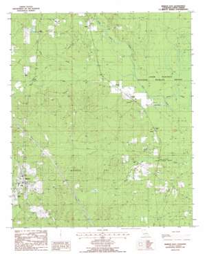
Marion East Topo Map Louisiana
To zoom in, hover over the map of Marion East
USGS Topo Quad 32092h2 - 1:24,000 scale
| Topo Map Name: | Marion East |
| USGS Topo Quad ID: | 32092h2 |
| Print Size: | ca. 21 1/4" wide x 27" high |
| Southeast Coordinates: | 32.875° N latitude / 92.125° W longitude |
| Map Center Coordinates: | 32.9375° N latitude / 92.1875° W longitude |
| U.S. State: | LA |
| Filename: | o32092h2.jpg |
| Download Map JPG Image: | Marion East topo map 1:24,000 scale |
| Map Type: | Topographic |
| Topo Series: | 7.5´ |
| Map Scale: | 1:24,000 |
| Source of Map Images: | United States Geological Survey (USGS) |
| Alternate Map Versions: |
Marion East LA 1988, updated 1988 Download PDF Buy paper map Marion East LA 2012 Download PDF Buy paper map Marion East LA 2015 Download PDF Buy paper map |
1:24,000 Topo Quads surrounding Marion East
> Back to 32092e1 at 1:100,000 scale
> Back to 32092a1 at 1:250,000 scale
> Back to U.S. Topo Maps home
Marion East topo map: Gazetteer
Marion East: Oilfields
Marion Gas Field elevation 46m 150′Marion East: Parks
Upper Ouachita National Wildlife Refuge elevation 18m 59′Marion East: Populated Places
Bemis elevation 30m 98′Cecil elevation 33m 108′
Dean elevation 32m 104′
Gravel elevation 32m 104′
Litroe elevation 31m 101′
Loco elevation 30m 98′
Marion elevation 54m 177′
Sadie elevation 48m 157′
Marion East: Post Offices
Marion Post Office elevation 49m 160′Marion East: Streams
Frank Lapere Creek elevation 21m 68′Marion East digital topo map on disk
Buy this Marion East topo map showing relief, roads, GPS coordinates and other geographical features, as a high-resolution digital map file on DVD:


