Eastwood Topo Map Louisiana
To zoom in, hover over the map of Eastwood
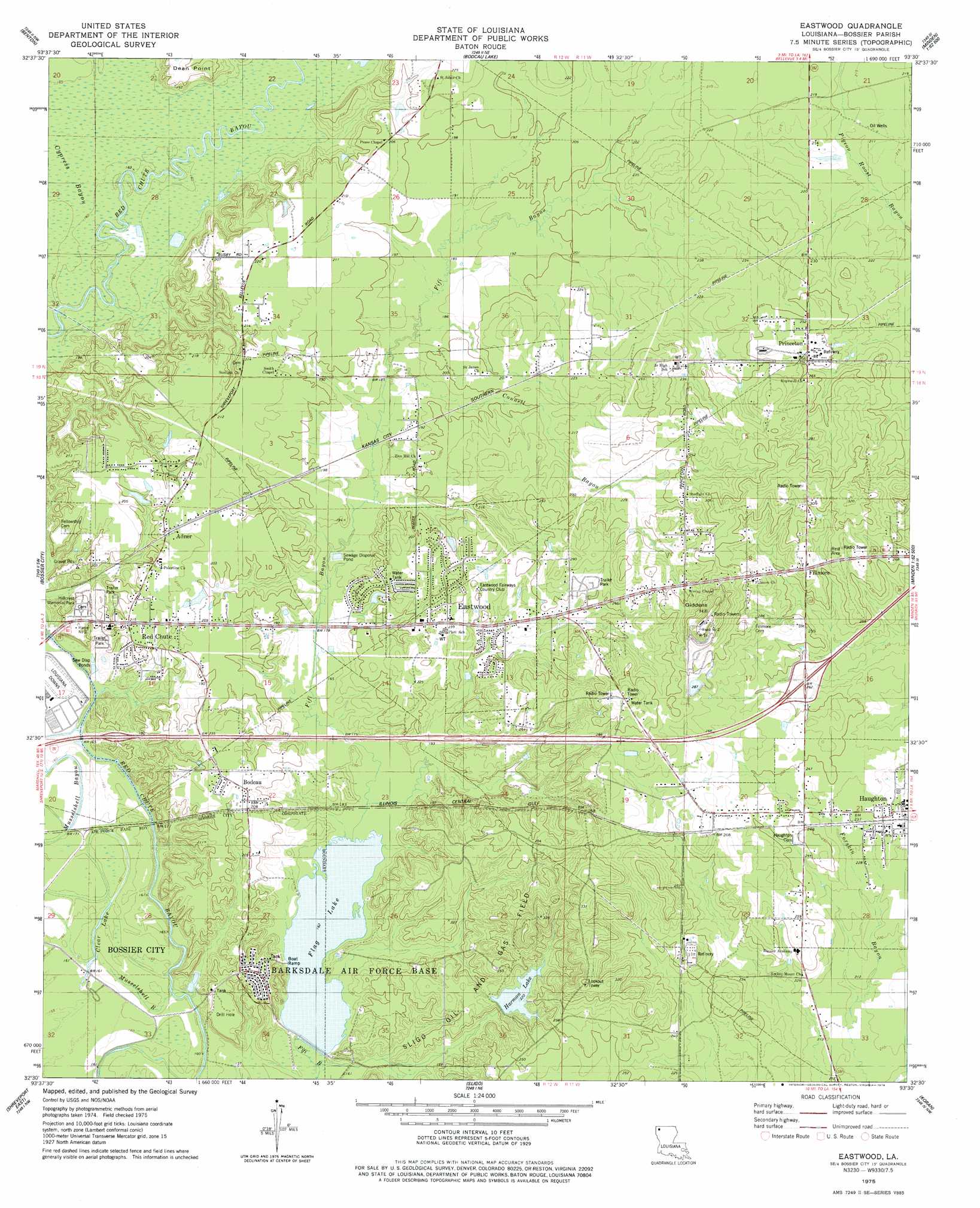
USGS Topo Quad 32093e5 - 1:24,000 scale
| Topo Map Name: | Eastwood |
| USGS Topo Quad ID: | 32093e5 |
| Print Size: | ca. 21 1/4" wide x 27" high |
| Southeast Coordinates: | 32.5° N latitude / 93.5° W longitude |
| Map Center Coordinates: | 32.5625° N latitude / 93.5625° W longitude |
| U.S. State: | LA |
| Filename: | o32093e5.jpg |
| Download Map JPG Image: | Eastwood topo map 1:24,000 scale |
| Map Type: | Topographic |
| Topo Series: | 7.5´ |
| Map Scale: | 1:24,000 |
| Source of Map Images: | United States Geological Survey (USGS) |
| Alternate Map Versions: |
Eastwood LA 1975, updated 1978 Download PDF Buy paper map Eastwood LA 1999, updated 2000 Download PDF Buy paper map Eastwood LA 2012 Download PDF Buy paper map Eastwood LA 2015 Download PDF Buy paper map |
1:24,000 Topo Quads surrounding Eastwood
Gilliam |
Hughes |
Ivan |
Cotton Valley |
Leton |
Dixie |
Benton |
Bodcau Lake |
Hortman |
Minden North |
North Highlands |
Bossier City |
Eastwood |
Doyline |
Minden South |
Shreveport West |
Shreveport East |
Sligo |
Koran |
Heflin |
Stonewall |
Wallace Lake |
Elm Grove |
Bossier Point |
Ringgold |
> Back to 32093e1 at 1:100,000 scale
> Back to 32092a1 at 1:250,000 scale
> Back to U.S. Topo Maps home
Eastwood topo map: Gazetteer
Eastwood: Airports
Touchstone Ridge Ultralight Airport elevation 58m 190′Eastwood: Capes
Dean Point elevation 65m 213′Eastwood: Crossings
Interchange 33 elevation 73m 239′Eastwood: Dams
Flag Lake Dam elevation 48m 157′Harmon Lake Dam elevation 83m 272′
Eastwood: Guts
Musselshell Bayou elevation 48m 157′Eastwood: Lakes
Clear Lake elevation 49m 160′Eastwood: Oilfields
Sligo Oil and Gas Field elevation 55m 180′Eastwood: Populated Places
Adner elevation 64m 209′Bodcau elevation 63m 206′
Bodcau Park elevation 64m 209′
Country Place elevation 64m 209′
Crestwood Heights elevation 66m 216′
Dogwood Acres elevation 63m 206′
Dogwood Estates elevation 65m 213′
Dogwood Forest elevation 62m 203′
Dogwood Hills elevation 66m 216′
Dogwood Park elevation 64m 209′
Eastwood elevation 73m 239′
Espanita Forest elevation 59m 193′
Espanita Village elevation 55m 180′
Fillmore elevation 85m 278′
Happy Meadows elevation 58m 190′
Haughton elevation 73m 239′
Holly Ridge elevation 64m 209′
Merrywoods elevation 76m 249′
Mimosa Gardens elevation 67m 219′
Morris elevation 63m 206′
Oak Thicket Acres elevation 65m 213′
Princeton elevation 80m 262′
Red Chute elevation 65m 213′
Shady Park elevation 60m 196′
South Merrywoods elevation 64m 209′
Tall Timbers elevation 61m 200′
Wafer Forest elevation 66m 216′
Eastwood: Post Offices
Haughton Post Office elevation 73m 239′Princeton Post Office elevation 87m 285′
Eastwood: Reservoirs
Flag Lake elevation 49m 160′Harmon Lake elevation 63m 206′
Eastwood: Streams
Connell Bayou elevation 55m 180′Cypress Bayou elevation 48m 157′
Eastwood: Summits
Giddens Hill elevation 124m 406′Eastwood digital topo map on disk
Buy this Eastwood topo map showing relief, roads, GPS coordinates and other geographical features, as a high-resolution digital map file on DVD: